Skip to content
Juniper Campground permit area in Mount Diablo State Park - backcountry hiking destination
One date at a time

Juniper Campground Permit

Mount Diablo State Park · California

Reservable campground on North Gate corridor.

Get an alert when Juniper opens on your dates.

Get alerts for your Juniper dates

One Juniper reservation is one date. Tell us every date you'd take and we'll ping you the second one of them opens up.

Leave the second date blank if only one day works. A wider window catches more openings.

Party

When it opens

6 months
First come, first served from six months before your start dateYou book on the agency's site.

Source: parks.ca.gov

70% of the openings our scanner caught on Juniper were gone within 10 minutes.

Juniper reservation dates

route distance, out and back
2mi

How to get a Juniper permit

As of September 2026, Juniper in Mount Diablo State Park, California requires a permit issued via reservation. Juniper is a high-demand permit, rating 7/10 on PermitSnag's demand index. Cancelled Juniper permits are re-released on the booking system, and PermitSnag alerts you the moment one opens. The Juniper route covers 2 miles, rated moderate.

Type
Overnight
Location
Diablo Range, CA
  1. Step 1: Create an account before permits drop

    Find this permit on the managing agency's booking system and set up an account with your payment info ready.

  2. Step 2: Know the release schedule

    Permits release on a rolling basis. Check the release time for your dates.

  3. Step 3: Be ready when permits drop

    Log in a few minutes early. Have your dates, group size, and payment ready to go.

  4. Step 4: Monitor for cancellations

    If your dates are sold out, people cancel all the time. Set up PermitSnag alerts to catch openings instantly.

More on Juniper: Live availability activityWhen Juniper permits open up

The Juniper hike

Distance
2 miles
Route Type
Out & Back
Duration
1-7 nights
Difficulty
Moderate
Elevation Range
3,000 - 3,849 ft

Juniper landmarks

  1. 1Diablo Valley Overlook

    Near Juniper Campground. From here you can see the Golden Gate Bridge.

  2. 2Mount Diablo summit

    About two miles above the campground on Summit Road, with the stone Summit Visitor Center.

  3. 3Mitchell Canyon

    Access point for trails on the mountain's north side, noted for its wildflower displays in spring.

  4. 4Rock City

    Sandstone formations near the South Gate, including the Wind Caves and Sentinel Rock.

Thirty-six sites at 3,000 feet, two miles below the summit, where the agency says you can see the Golden Gate Bridge from a nearby overlook.

About this permit

Juniper Campground sits about two miles below the summit on Summit Road at 3,000 feet, with 36 sites and the views the campground is known for. Three campsites meet ADA accessibility standards: sites 9, 10 and 19. All campsites are provided with picnic tables, fire pits or stoves, water, and restrooms, and showers are available at Live Oak and Juniper campgrounds at no additional cost.

Reservations for Live Oak and Juniper go through ReserveCalifornia, six months in advance from the current date. The rate is $30 a night in all seasons.

The altitude is the reason to choose it. The park warns of extreme heat in summer, and camping about 1,550 feet above Live Oak is the practical answer to that. The trade is wind exposure and a longer, steeper drive.

As at Live Oak, campers are locked in the park overnight from sunset to 8:00 am, and during fire season, generally May to October, the park is subject to closure due to extreme fire danger. Call the park one day prior to arrival to confirm.

The route

Juniper Campground is located about 2 miles below the summit on Summit Road, and is known for its fantastic views. The Mount Diablo Interpretive Association lists 36 sites at 3,000 feet, and three campsites meet Americans with Disabilities Act accessibility standards. State Parks names sites 9, 10 and 19, with accessible parking and level table and tent areas, and a restroom/shower building with accessible parking.

From the Diablo Valley Overlook near Juniper Campground, 2,900 feet above sea level, you can see the Golden Gate Bridge. The summit at 3,849 feet holds a Visitor Center in a historic stone building constructed in the late 1930s of fossiliferous sandstone blocks quarried in the park; it is open 7 days a week from 10:00 am to 4:00 pm, though the elevator is out of service until further notice.

All campsites are provided with picnic tables, fire pits or stoves, water, and restrooms, and showers are available at Live Oak and Juniper campgrounds at no additional cost.

Why it matters

Juniper is the high camp on Mount Diablo, about 1,550 feet above Live Oak, which makes it the summer option on a mountain the park warns can have extreme heat. It is also the closest camp to a summit with a viewshed the agency puts at over 8,539 square miles and parts of 40 of California's 58 counties.
The feeling

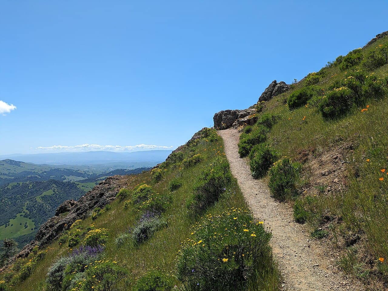
Thin, dry chaparral on an exposed shoulder with the whole Bay Area below. Wind is real up here, and the temperature swing between afternoon and night is large.

Juniper hike highlights

  1. 36 sites at 3,000 feet, about two miles below the summit
  2. Three accessible campsites: sites 9, 10 and 19
  3. Picnic tables, fire pits or stoves, water and restrooms; showers at no extra cost
  4. Being locked into the park from sunset to 8:00 am
  5. Real wind exposure on a high shoulder
  6. $30 a night in all seasons

How hard the Juniper hike is

  • Physical DemandFitness and endurance required1/5
  • Technical SkillClimbing, scrambling, or specialized skills1/5
  • Exposure RiskSteep dropoffs and fall potential3/5
  • NavigationRoute finding and trail clarity1/5
  • CommitmentDifficulty of bailing out mid-route2/5

Best for: Campers who want height and views over shelter, and anyone camping on Diablo in warm months: 1,550 feet above Live Oak is the difference between pleasant and punishing.

Recommended experience: None. Pitch for wind and carry extra water.

Not recommended for: Anyone with a rig over 20 feet, anyone bothered by wind, and anyone who needs to leave after dark. Dogs cannot go on any trail or fire road.

Trailhead information

Juniper Campground, Summit Road

Primary

3,000 ft elevation

The high campground about two miles below the summit, with three accessible campsites (9, 10 and 19) and an accessible restroom/shower building.

  • Restrooms
  • Water on site

Parking

Additional vehicle $10.00 per night, limit 1. Maximum trailer and maximum camper/motorhome length both 20 feet.

Getting There

All camping registration is at the South Gate kiosk. Gates open 8:00 am and close at sunset. The roads are shared with cyclists: the park has 67 bike turnouts along South Gate, North Gate and Summit Roads.

Nearest Services

Walnut Creek or Danville.

Trailhead information

North Gate Road Entrance

Alternate

The northern entrance at 1300 North Gate Road, Walnut Creek.

  • No restrooms
  • No water

Parking

Vehicle entrance fee $10.00. Cash or check anytime, credit and debit when the kiosk is staffed.

Getting There

Take Highway 680 to Walnut Creek. Registration for camping still happens at South Gate.

Nearest Services

Walnut Creek.

When to hike Juniper

Best time to visit

Spring and autumn are best overall, and Juniper is the better of the two campgrounds in summer purely because of its altitude. The day after a winter storm gives the clearest views the mountain offers; summer days are sometimes hazy.

Weather Forecast

Trailhead (5,000 ft)

Today

☀️

80°

62°

Wed

☀️

83°

67°

Thu

☁️

83°

59°

Fri

☁️

85°

56°

Sat

☁️

90°

58°

Sun

☀️

90°

58°

Mon

☀️

90°

59°

View full NWS forecast →Mountain weather changes rapidly. This forecast is a guide—always be prepared for worse conditions.

Juniper photography guide

Golden Hour

Sunset from the summit road above camp, looking west past the Golden Gate to the Farallon Islands on a clear evening.

Best Light

The day after a winter storm, which the agency names as the best viewing. Summer days are sometimes hazy.

Beat the Crowds

Day traffic goes to the summit and leaves before the gates close at sunset. Campers are locked in overnight and have the high mountain to themselves.

Classic Shots

  1. The Golden Gate Bridge from the Diablo Valley Overlook
  2. The stone Summit Visitor Center tower
  3. Layered ridges of the Diablo Range at dawn
  4. Spring wildflowers at Mitchell Canyon
  5. A high camp above an inversion with the valleys filled

Juniper rules, gear and safety

Gear checklist

Required
  • Extra water: the campground water source depends on spring production and drought has affected availability
  • Camp stove, since fires can be restricted or prohibited when fire danger is high
  • Wind-worthy tent and extra stakes for an exposed 3,000-foot shoulder
  • Warm layers; the park warns of extreme heat, wind, cold, rain and snow
  • Firewood bought off the mountain

Recommended gear

  • A call to 925-837-2525 or 925-837-0904 the day before arrival in fire season
  • Binoculars: the agency says you can see almost 200 miles on the best days
  • Long sleeves and long pants for ticks and poison oak
  • A quart of water for every two hours of hiking
  • Headlamp, since driving out after sunset is not allowed

Rules & regulations

  1. 01Check-in time is 2:00 pm. Check-out time is 12:00 noon. The entrance and exit gates are closed from sunset to 8:00 am.
  2. 02Maximum length of stay 15 consecutive days, 30 days in a calendar year.
  3. 03Maximum trailer, camper and motorhome length 20 feet.
  4. 04Quiet hours are from 10:00 pm to 6:00 am. No electric generators from 8:00 pm to 10:00 am.
  5. 05Collection of firewood is prohibited in the park, and weather conditions may restrict smoking or prohibit fires entirely.
  6. 06Consumption of alcoholic beverages is prohibited in the park.
  7. 07Dogs are NOT permitted on trails, fire roads, or in park buildings; only in developed areas, on leash by day and enclosed at night.
  8. 08Campers are not allowed to drive in the park at night unless there is an emergency or a scheduled Public Astronomy Program at the Summit.
  9. 09During fire season, generally May to October, call the park one day prior to arrival to confirm park status.

Hazards & considerations

  • Mount Diablo State Park can have extreme heat, wind, cold, rain, snow.
  • The park's potable water depends on spring production; several years of drought has affected water availability on the mountain.
  • Ticks are found on Mt. Diablo; check yourself and your children frequently.
  • Rattlesnakes are common in warmer months; keep at least 6 feet away.
  • Poison oak: learn the shiny three-leaf pattern and stay on trail.
  • Limited cell service on many trails, which can be very remote; airlifting injured individuals can cost over $50,000.
  • It is over 7 miles one way and 3,000 feet of elevation to hike to the summit; the park warns not to attempt it unless you are certain you can double those numbers to get back.

Safety & planning

Emergency Info

Emergency contacts, ranger station locations, and satellite communicator tips for Juniper.

Food Storage

Bear canister requirements, approved container lists, and rental locations for this permit.

Gear Checklist: Required and recommended gear for Juniper · Shuttle Services: Trailhead transportation options · Guide Services: Experienced wilderness guides

Some links may be affiliate links. Purchases support PermitSnag at no extra cost to you.

Juniper FAQ

How do I get a Juniper permit?

PermitSnag alerts you the moment a Juniper cancellation opens, so you can book it before anyone else. Juniper permits use a reservation system.

When is the best time to visit Juniper?

Season dates are on the agency's page. Weekdays have better availability than weekends.

How competitive is the Juniper permit?

This permit has a demand score of 7/10, making it highly competitive. We recommend having backup dates and using PermitSnag's cancellation alerts.

What if I can't get a Juniper permit?

Cancellations happen daily. Set up alerts with PermitSnag to get notified the moment a spot opens up. Pro and $19 single-permit alerts are checked about every minute, 24/7; free accounts are checked hourly.

Juniper trail conditions and trip reports

Trail Conditions

No active conditions reported

Sign in to report trail conditions.

Questions

No questions yet

Be the first to ask about Juniper.

Trip Reports

Write Report

No trip reports yet

Be the first to share your experience at Juniper.

Write the First Report

Alternatives to a Juniper permit

  • Same AreaPermit required

    Live Oak Campground

    Twenty-two sites at 1,450 feet, one mile above the South Gate entrance and near Rock City.

    Tradeoffs

    Lower, warmer and more sheltered, with Rock City's formations nearby. Noticeably hotter in summer and without the summit views.

  • Similar ExperiencePermit required

    Henry W. Coe Backpacking Zone Permit

    First-come backcountry permits across 87,000 acres of the Diablo Range. You register at the park entrance rather than reserving.

    Tradeoffs

    The same range at a far wilder scale with no reservation needed, but summer heat is serious and water sources need checking before you choose a route.

  • Similar ExperiencePermit required

    Mount San Jacinto Wilderness Camping Permit

    A per-person wilderness camping permit for primitive campgrounds in the San Jacinto high country.

    Tradeoffs

    Genuine high-mountain terrain and far cooler summers, but a very long drive south.

Plan the full trip, not just the permit

Build your full itinerary start to finish

Add your dates and get a day-by-day plan: what needs a permit, what gear to bring, and one link to share with your whole group to coordinate every step.

Plan a trip here

No permit needed to start

One tick helps us more than you’d think

Google lets you pick the sites it highlights for you. Add PermitSnag and our permit pages get marked as one of yours in AI Overviews and AI Mode.

Add PermitSnag in Google

Takes less than a minute.