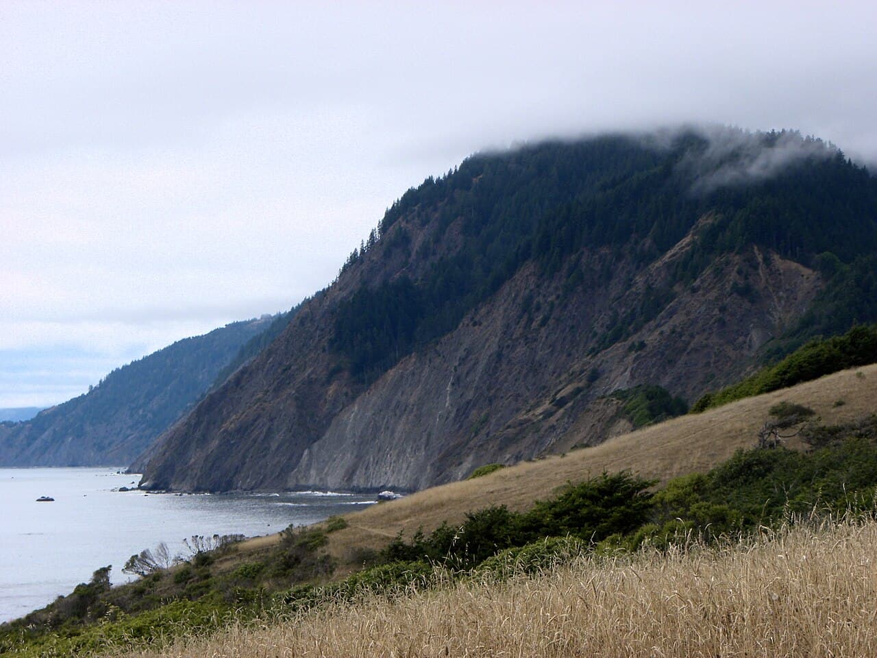
Hike-in environmental camp on the Lost Coast Trail. Pay on site, no reservations.
“An environmental camp on the largest and most protected cove in Sinkyone Wilderness, at the site of a former logging settlement.”
Plan your Sinkyone Wilderness State Park trip here, then get your permit from the agency.
Walk-up permit
How to get Bear Harbor
Bear Harbor is issued by the agency rather than through a booking calendar. Their page has the current process and any dates.
Official permit pagePlanning another trip? See the permits we alert on.
How to get a Bear Harbor permit
No reservation. You get the permit when you arrive.
Arrive at Needle Rock Visitor Center (Briceland Road)
Fill in the permit and pay
See the fees below.
Head out
Sinkyone trailheads and fees
- Needle Rock Visitor Center (Briceland Road)
Sinkyone trailhead in full
Primary
Needle Rock Visitor Center (Briceland Road)The northern access and registration point. Briceland Road continues south from here toward Orchard Camp and Bear Harbor.
- Restrooms
- No water
Parking
Day-use parking $8 per vehicle per day for Needle Rock and Jones Beach. Environmental camps cost $5 per person per night, payable at Jones Beach gate or Needle Rock, or by mail. Several parking places are available at the Needle Rock Visitor Center.
Getting there
North end of wilderness: 36 miles southwest of Garberville or Redway on Briceland Road, which becomes Mendocino County Road 435. The last 3.5 miles are unpaved, steep and narrow, and the road is closed in winter. Roads may be impassable in wet weather; RVs and trailers are not recommended.
Nearest services
Garberville or Redway, 36 miles away.
- Type
- Overnight
- Location
- Lost Coast, CA
How this permit is issued
Get this permit in person at the trailhead or ranger station, or by phone.
Official permit page →Step 1: Check the agency page for the process
This permit is not sold online. Confirm where and when it is issued (and any fee) at California State Parks before your trip.
Step 2: Arrive early
Walk-up permits are issued first-come, first-served. Where the agency sets a daily quota, popular trailheads can run out on weekends and holidays.
Step 3: Have backup plans
Popular trailheads fill fast. Know alternate routes or dates.
More on Bear Harbor: Live availability activity
How much a Bear Harbor permit costs
Bear Harbor permit fee: $5 per person per night (pay at Jones Beach gate or Needle Rock).
The Bear Harbor hike
- Route Type
- Out & Back
- Difficulty
- Moderate
Bear Harbor landmarks
- 1Bear Harbor
The largest and most protected cove in the park, three to four acres of beach at the site of a former logging settlement.
- 2Needle Rock Visitor Center
The park's staffed center, a 1920s dairy settlement house with year-round camp hosts, and a fee payment point.
- 3Lost Coast Trail
22 miles within Sinkyone. A foot trail from Usal Beach to Bear Harbor, then following Briceland Road to Needle Rock.
- 4Orchard Camp
A Briceland Road environmental camp, 2.7 miles south of Needle Rock by road.
An environmental camp on the largest and most protected cove in Sinkyone Wilderness, at the site of a former logging settlement.
About this permit
Bear Harbor Camp is an environmental camp on the largest and most protected cove in Sinkyone Wilderness State Park, at the site of a former logging settlement. The beach is three to four acres and the camp is accessible by Briceland Road, County Road 435, except during the rainy season.
Sinkyone offers eight environmental camps, two horse camps, and two primitive camps. Primitive camps offer drive-in access, while environmental camps do not. Environmental camps and horse camps cost $5 per person per night and are payable at Jones Beach gate or Needle Rock, or by mail via check to the California Department of Parks and Recreation at 1600 US 101, Box No. 8, Garberville, CA 95542. There is no ReserveCalifornia booking for these camps. The park's own reservation field reads that there are no upcoming camping or lodging reservations.
The park's conditions define the trip. There is no potable water, and you have to haul out your own trash. When wet, the park's twisting dirt roads are impassable for passenger cars. Vault toilets are available throughout the park in all developed use areas.
The park's June 2006 Preliminary General Plan and Draft EIR lists four sites at Bear Harbor.
The route
Bear Harbor, the site of a former logging settlement, is the largest and most protected cove in the park. It is a large beach of three to four acres and accessible by Briceland Road, County Road 435, except during the rainy season.
On the Lost Coast Trail it is the hinge point: the trail begins at the south end of the park at Usal Beach Campground and remains a foot trail until it reaches Bear Harbor; from Bear Harbor to Needle Rock the trail follows Briceland Road and then resumes as a hiking trail north of Needle Rock. Environmental campsites easily reachable from the southern end of Briceland Road are located at Orchard Camp, Railroad Camp, and Bear Harbor Camp.
The park's 2006 Preliminary General Plan and Draft EIR records four campsites at Bear Harbor. Environmental camps do not offer drive-in access; primitive camps do.
Why it matters
Bear Harbor is the pivot of the Lost Coast Trail inside the park: the point where the trail stops being a foot path and starts following Briceland Road north toward Needle Rock. It is also the most sheltered landing on a coastline with almost none.
The feeling
A protected cove three to four acres across, backed by Douglas fir and coastal prairie where Roosevelt elk graze. Fog most mornings, and no sound but surf.
Bear Harbor hike highlights
- An environmental camp: no drive-in access, unlike the park's two primitive camps
- $5 per person per night, paid at Jones Beach gate, Needle Rock, or by mail
- No potable water anywhere in the park
- Vault toilets in developed use areas
- A sheltered cove, unusual on this coastline
- Briceland Road closed in winter and impassable when wet
How hard the Bear Harbor hike is
- Physical DemandFitness and endurance required3/5
- Technical SkillClimbing, scrambling, or specialized skills2/5
- Exposure RiskSteep dropoffs and fall potential4/5
- NavigationRoute finding and trail clarity3/5
- CommitmentDifficulty of bailing out mid-route4/5
Best for: Lost Coast Trail hikers and campers who want the most sheltered cove on this coastline, and who are prepared to be far from help.
Recommended experience: Backcountry self-sufficiency, bear canister discipline, and a realistic view of a road that closes in winter and can strand you for a day or two.
Not recommended for: Beginner backpackers: the park says the trail is rugged, strenuous and not recommended for them. Anyone in a low-clearance vehicle in wet weather, and anyone who needs a trash service or drinking water.
When to hike Bear Harbor
Best time to visit
Summer and early autumn, when Briceland Road is open and dry. The road is closed in winter and impassable when wet. The park notes that the remote distance from populated areas limits visitors to weekends or the summer season.
Weather Forecast
Trailhead (5,000 ft)
Today
85°
62°
Wed
82°
67°
Thu
78°
65°
Fri
80°
64°
Sat
80°
66°
Sun
80°
67°
Mon
79°
65°
Bear Harbor photography guide
Golden Hour
Sunset over the protected cove, which holds light longer than the exposed beaches either side.
Best Light
Late summer and early autumn.
Beat the Crowds
The road handles it. Briceland Road's last 3.5 miles are unpaved, steep and narrow, and it is closed in winter.
Classic Shots
- The cove at Bear Harbor with its sheltering headlands
- Roosevelt elk on the coastal prairies
- Fog moving through Douglas fir above the cove
- The Lost Coast Trail where it meets the road
Bear Harbor rules, gear and safety
Gear checklist
Required- All your drinking water: there is no potable water in the park
- A bear canister for food and scented items
- Full trash carry-out capacity
- Warm, waterproof layers for a fog-bound coast
- Extra food and supplies in case you are stranded
Recommended gear
- Cash or a check for the $5 per person fee
- A paper map and an itinerary left with someone at home
- A tide table before walking any beach section
- High-clearance vehicle for Briceland Road
- A satellite messenger, since cellphone connectivity is limited
Rules & regulations
- 01Environmental camps and horse camps cost $5 per person per night, payable at Jones Beach gate or Needle Rock, or by mail.
- 02Except for service animals, dogs are not allowed on trails.
- 03Store food and any scented items in a bear canister when camping; items may also be stored in a locked car.
- 04Haul out your own trash. There is no trash service in the park.
- 05Due to rough driving conditions, large trailers and RVs are not recommended.
- 06Day use areas open sunrise to sunset. Day-use parking is $8 per vehicle per day for Needle Rock and Jones Beach.
- 07No trails in this park are Americans with Disabilities Act-accessible.
Hazards & considerations
- Sinkyone Wilderness SP is one of the most remote parks in California. In an emergency situation, help may not arrive for hours.
- Hiking on the shoreline can be dangerous, and cellphone connectivity is limited.
- The cold waters off the rugged North Coast are unpredictable and can be deadly, not only for beginners but even for experts.
- There is no potable water in the park.
- When wet, the park's twisting dirt roads are impassable for passenger cars, and mudslides or fallen trees can close your route home.
- Briceland Thorn Road is closed in winter.
- Black bears: food and scented items must go in a bear canister or a locked car.
Safety & planning
Emergency Info
Emergency contacts, ranger station locations, and satellite communicator tips for Bear Harbor.
Food Storage
Bear canister requirements, approved container lists, and rental locations for this permit.
Gear Checklist: Required and recommended gear for Bear Harbor · Shuttle Services: Trailhead transportation options · Guide Services: Experienced wilderness guides
Some links may be affiliate links. Purchases support PermitSnag at no extra cost to you.
Bear Harbor FAQ
How do I get a Bear Harbor permit?
Bear Harbor is issued directly by the agency. It is issued in person or by phone, so there is no reservation to book and no cancellation to catch. Bring backup dates and check their page for the current process.
When is the best time to visit Bear Harbor?
Season dates are on the agency's page. Weekdays have better availability than weekends.
How competitive is the Bear Harbor permit?
This permit has a demand score of 6/10, making it moderately competitive.
What if I can't get a Bear Harbor permit?
The agency awards this permit directly. Bring backup dates and check the official page for the current process and any closures.
Bear Harbor trail conditions and trip reports
Trail Conditions
No active conditions reported
Sign in to report trail conditions.
Questions
No questions yet
Be the first to ask about Bear Harbor.
Trip Reports
Write ReportAlternatives to a Bear Harbor permit
- Same AreaNo permit needed
Orchard Camp
An environmental camp on Briceland Road 2.7 miles south of Needle Rock, with about five parking places nearby.
Tradeoffs
The nearest neighbor on the same road, easier to reach when the summer road section is open. No cove, though.
- Same AreaNo permit needed
Wheeler Camp
A hike-in environmental camp on the Lost Coast Trail between Usal Beach and Bear Harbor.
Tradeoffs
Trail-only, with no road anywhere near it: the wilder choice for the same money.
- Easier AlternativeNo permit needed
Usal Beach Camp
Thirty free drive-in campsites on a black sand beach at the park's southern end.
Tradeoffs
Drive-in and free, which makes it far easier. But it sees the most use in the park and the access road is a six-mile unpaved climb.
Where to stay near Bear Harbor
- Richardson Grove Sp Madrone Campground (sites 37-76)Richardson Grove SP
- Richardson Grove Sp Madrone Cabin Area campgroundRichardson Grove SP
- Richardson Grove Sp Huckleberry Campground (sites 1-36)Richardson Grove SP
- All California campgrounds
Plan the full trip, not just the permit
Build your full itinerary start to finish
Add your dates and get a day-by-day plan: what needs a permit, what gear to bring, and one link to share with your whole group to coordinate every step.
No permit needed to start
One tick helps us more than you’d think
Google lets you pick the sites it highlights for you. Add PermitSnag and our permit pages get marked as one of yours in AI Overviews and AI Mode.
Takes less than a minute.