White Rim Road — Airport C Campsite Permit
Canyonlands National Park · Utah
Campsite permit for Airport C on the White Rim Road in Canyonlands.
Get an alert when a night opens on your Airport C dates.
70% of the openings our scanner caught on Airport C were gone within 10 minutes.
Airport C reservation dates
- Season
- Year-round
- route distance, loop
- 100mi
- max group size
- 15people
How to get an Airport C permit
As of September 2026, Airport C in Canyonlands National Park, Utah requires a permit issued via reservation. Airport C is a high-demand permit, rating 8/10 on PermitSnag's demand index. Cancelled Airport C permits are re-released on the booking system, and PermitSnag alerts you the moment one opens. The permit season for Airport C runs year-round. The Airport C route covers 100 miles, rated moderate.
- Type
- Overnight
- Location
- Colorado Plateau, UT
Step 1: Create a Recreation.gov account
Sign up at Recreation.gov if you don't have an account. Have your payment info ready.
Step 2: Know the release schedule
Permits release on a rolling basis. Check the release time for your dates.
Step 3: Be ready when permits drop
Log in a few minutes early. Have your dates, group size, and payment ready to go.
Step 4: Monitor for cancellations
If your dates are sold out, people cancel all the time. Set up PermitSnag alerts to catch openings instantly.
Airport C pro tips
- Set an alarm for 8 a.m. Mountain time on the release date four months before your season opens. That first minute is when spring and fall dates go.
- Airport C is one of only 20 campsites on a 100-mile road, so a cancellation alert is doing real work here. There is no overflow.
- Carry every drop of water you plan to drink. There is none on the road and no way to buy any.
- Budget 1.5 hours from the visitor center just to reach camp, before you factor in stops.
- If you are riding it, bring a four-wheel-drive support vehicle for water and gear. NPS recommends it directly.
- Check current road conditions before you commit. High water on the Green River can close the west side and turn the loop into an out-and-back.
- Cancel early if your plans change. The $5 per person per night fee is refunded for trips cancelled at least 3 days out, and someone else gets the night.
More on Airport C: Live availability activityWhen Airport C permits open up
How much an Airport C permit costs
Airport C permit fee: $36 non-refundable reservation fee per permit (includes the $6 Recreation.gov fee) plus $5 per person, per night. Park entrance fee is separate.
The Airport C hike
- Distance
- 100 miles
- Route Type
- Loop
- Duration
- 2-4 days
- Difficulty
- Moderate
Airport C landmarks
- 1Shafer Trail switchbacks
The descent you take to get here, one of the five steep exposed sections NPS names on the loop
- 2Airport camping area
Four campsites (A-D) and two toilets, 1.5 hours from the Island in the Sky Visitor Center
- 3Gooseberry camping area
The next camps clockwise, 3 hours from the visitor center
One of four sites in the Airport area at mile 19, an hour and a half in, the standard first night for a clockwise White Rim trip.
About this permit
Airport C is one of four campsites in the Airport camping area, at mile 19 of the White Rim Road and about 1.5 hours of driving clockwise from the Island in the Sky Visitor Center. Two toilets serve the area. It is the largest camping area on a road that has 20 individual campsites arranged in 10 areas, which is why it is the usual first night on a clockwise circuit.
The 100-mile loop runs around and below the Island in the Sky mesa top. NPS puts four-wheel-drive trips at two to three days and mountain bike trips at three to four, and asks for a minimum of 10 to 12 hours of driving or cycling. When there is more than one campsite at a location, NPS says they are generally positioned to be out of earshot and, as much as possible, out of sight of each other.
High-clearance four-wheel drive with low range is required, campfires are not permitted, pets are not allowed even inside vehicles, and there is no potable water along the road.
Canyonlands releases White Rim permits four months before each season starts, at 8 a.m. Mountain time on Recreation.gov, and NPS says outright that demand for overnight permits frequently exceeds the number available in spring and fall. The fee is a $36 non-refundable reservation charge plus $5 per person per night. Anything still unreserved becomes a walk-up, marked "W" on Recreation.gov and issued in person at a visitor center until 2:30 p.m. Mountain time.
The route
Airport sits at mile 19 clockwise from the Island in the Sky Visitor Center, which NPS estimates at 1.5 hours of driving. The area holds four campsites (A through D) and two toilets, the biggest concentration on the loop. Airport C is booked on Recreation.gov as its own named site, so you are reserving this exact spot rather than an area. Coming from the visitor center you will have already dropped the Shafer Trail, the first of the five steep and exposed sections NPS names on the road.
Why it matters
The Airport area is the largest cluster on the road: four of the twenty White Rim campsites sit here, served by two toilets. That density is why it is the default first night on a clockwise circuit. A party that cannot get one Airport site can often get another, and groups splitting across two permits can stay near each other. NPS positions the sites in each area to be out of earshot and, as far as possible, out of sight of one another, so four sites does not mean a campground.
The feeling
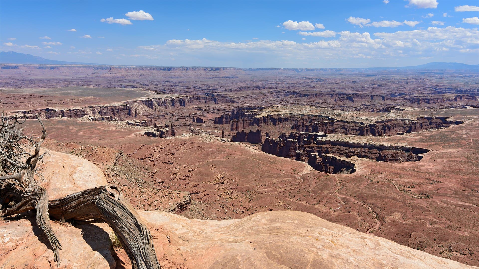
Mile 19 is far enough that the mesa rim above you reads as a wall rather than a road you just came down. The bench opens out and the light does the work: red rock, and a horizon of nothing but more canyon. Four parties can be scattered across the Airport area on a given night and you will likely see none of them.
Airport C hike highlights
- Four campsites (A through D) in the Airport area, served by two toilets
- 19 miles and about 1.5 hours of driving from the Island in the Sky Visitor Center, clockwise
- Sites positioned to be out of earshot and, as much as possible, out of sight of each other
- No potable water, no shade, no campfires and no generators
- A hard cap of 15 people and 3 vehicles on the site
- A named-site reservation on Recreation.gov, not an area permit
How hard the Airport C hike is
- Physical DemandFitness and endurance required3/5
- Technical SkillClimbing, scrambling, or specialized skills3/5
- Exposure RiskSteep dropoffs and fall potential3/5
- NavigationRoute finding and trail clarity1/5
- CommitmentDifficulty of bailing out mid-route2/5
Best for: Drivers with a true low-range four-wheel-drive vehicle, and cyclists who have a support vehicle carrying water. NPS highly recommends a four-wheel-drive support vehicle for mountain bike trips.
Recommended experience: Comfort on steep, exposed, unpaved switchbacks and enough self-recovery skill to deal with a stuck vehicle 40 miles from pavement.
Not recommended for: Anyone in an all-wheel-drive crossover, anyone bringing a dog, anyone over 8 feet wide or 9.5 feet tall, and anyone hoping to buy water along the way.
When to hike Airport C
Best time to visit
Spring and fall, which is exactly when NPS says demand for overnight permits frequently exceeds supply. Four sites in one area gives a cancellation alert more to work with here than anywhere else on the road. Summer is hot and unshaded but bookable.
- Peak
- March through May and September through October
- Shoulder
- November through February
Spring
The busiest season on the road and the reason permits sell out. Warm days, cold nights, and the highest chance of a full loop being drivable.
Crowd level · extreme
- Advantage: Comfortable daytime temperatures for riding or driving
- Advantage: Long enough days for the big mileage between camps
- Advantage: Every camp in the loop is usually reachable
- Challenge: NPS says demand for overnight permits frequently exceeds the number available in spring
- Challenge: Green River high water can close west-side sections
- Challenge: Cold nights on an exposed bench
Summer
Hot and unshaded. The bench holds heat and there is no water on the road.
Crowd level · low
- Advantage: The easiest season to actually get a permit
- Advantage: Long daylight for the longer driving days
- Advantage: Afternoon storms bring the only real color changes on the bench
- Challenge: Heat with no shade and no water source
- Challenge: Afternoon thunderstorms make the steep sections dangerous
- Challenge: Sand is at its softest and deepest
Fall
The other peak season. Stable weather, cool nights, and the same permit pressure as spring.
Crowd level · extreme
- Advantage: Best combination of temperature and stable weather
- Advantage: Low river levels usually keep the west side open
- Advantage: Clear air for the long views off the bench
- Challenge: NPS names fall alongside spring as the season when demand exceeds supply
- Challenge: Daylight shortens fast through October
- Challenge: Nights get cold quickly once the sun drops below the rim
Winter
Cold, quiet, and the season with real availability. Snow and ice change the calculus on the steep sections.
Crowd level · low
- Advantage: Permits are easier to get
- Advantage: Snow on red rock is the rarest photograph out here
- Advantage: You may not see another vehicle all day
- Challenge: Ice on the Shafer, Murphy Hogback, Hardscrabble and Mineral Bottom grades
- Challenge: Short days against long driving times between camps
- Challenge: Nothing on the bench is heated and nothing is close
Weather Forecast
Trailhead (5,000 ft)
Today
70°
57°
35%
Wed
80°
59°
Thu
82°
56°
Fri
85°
63°
Sat
86°
65°
Sun
86°
65°
Mon
83°
64°
Airport C photography guide
Golden Hour
First and last light on the White Rim bench, when the low sun rakes across the sandstone and the shadows separate the benches from the canyon below Airport.
Best Light
Night. This is one of the darkest corners of the Colorado Plateau, and the Milky Way over the bench is the shot people drive out here for.
Beat the Crowds
Only 4 parties can be at Airport on any given night, so once the day traffic clears the road you have it to yourself.
Classic Shots
- The rim wall above camp catching the first sun while the bench is still in shadow
- Your vehicle small against the bench, for scale
- The Island in the Sky mesa top a thousand feet above, seen from below
- Star trails over the canyon rim from camp
Airport C rules, gear and safety
Gear checklist
Required- All your water. There is none on the road, and 1 gallon per person per day is the NPS floor
- A high-clearance four-wheel-drive vehicle with low range. This is a requirement, not a recommendation
- Full recovery kit and a spare: shovel, traction boards, air compressor, tire plugs
- A camp stove. Fires are not permitted at any White Rim campsite
- Shade you bring yourself, such as a tarp or awning; there is almost none on the bench
- Printed maps. Cell service is unreliable below the mesa rim
Rules & regulations
- 01Each campsite accommodates up to 15 people and 3 vehicles; motorbikes and trailers count as vehicles for that limit
- 02Keep all camp activities within the posts that mark the campsite boundaries
- 03Campfires are not permitted anywhere along the White Rim Road, and generators are not allowed
- 04Pets are not permitted, even inside vehicles
- 05Your vehicle must have high-clearance, four-wheel drive with low range
- 06ATVs, UTVs and OHVs are not permitted even if street legal; drones and other unmanned aircraft are prohibited
- 07All vehicles and bikes must remain on designated roads
- 08You may stay a maximum of three consecutive nights at a camping area before having to relocate, and an overnight permit runs up to 14 consecutive nights
- 09Climbing, scrambling, walking or standing upon, or rappelling off any arch is prohibited parkwide
- 10Recreation.gov books Airport as a named campsite, not a zone. You are reserving this exact site for the night
Hazards & considerations
- No potable water anywhere along the road. NPS asks for at least 1 gallon (4 L) per person per day, more if you will be active
- Long rocky stretches, deep sand and little shade; NPS says to plan on a minimum of 10 to 12 hours of driving or cycling for the loop
- The steep, exposed sections at Shafer Trail, Lathrop Canyon Road, Murphy Hogback, Hardscrabble Hill and the Mineral Bottom switchbacks demand extreme caution in bad weather
- High water on the Green River can flood sections of road on the west side and make a complete loop impossible
- A disabled vehicle out here is expensive: NPS warns of towing fees in excess of $1,000
- Summer heat on an unshaded sandstone bench, with no water and no quick way out
Safety & planning
Emergency Info
Emergency contacts, ranger station locations, and satellite communicator tips for Airport C.
Food Storage
Bear canister requirements, approved container lists, and rental locations for this permit.
Gear Checklist: Required and recommended gear for Airport C · Shuttle Services: Trailhead transportation options · Guide Services: Experienced wilderness guides
Some links may be affiliate links. Purchases support PermitSnag at no extra cost to you.
Airport C FAQ
How do I reserve the Airport C campsite on the White Rim Road?
Through Recreation.gov, on Canyonlands' seasonal release schedule. Permits open four months before the start of the season at 8 a.m. Mountain time: spring dates (March 10 to June 9) on November 10, summer (June 10 to September 9) on February 10, fall (September 10 to December 9) on May 10, and winter (December 10 to March 9) on August 10.
How many people can stay at the Airport C campsite?
Fifteen. NPS states that each White Rim campsite accommodates up to 15 people and 3 vehicles, and motorbikes and trailers count as vehicles against that limit.
Is there water at the Airport C campsite?
No. NPS is explicit that there is no potable water along the White Rim Road, so every drop comes in with you. The park asks for at least 1 gallon (4 L) per person per day, and more if you will be active. For bike trips it highly recommends a four-wheel-drive support vehicle to carry water and equipment.
How far is Airport C from the Island in the Sky Visitor Center?
19 miles travelling clockwise, which NPS estimates at 1.5 hours of driving. The full White Rim Road loop is 100 miles, and NPS says four-wheel-drive trips usually take two to three days and mountain bike trips three to four.
Can I have a campfire at Airport C?
No. Campfires are not permitted anywhere on the White Rim Road, and generators are not allowed either. Bring a camp stove.
Do I need a day-use permit as well as an overnight permit for the White Rim Road?
No. All vehicles, motorbikes and bicyclists need a day-use permit for single-day trips on the White Rim, but overnight trips do not need an additional day-use permit.
What happens to White Rim campsites that nobody reserves?
They go to walk-up. Any campsite that remains unreserved shows on Recreation.gov as "W" and is issued in person at a visitor center, seven days a week, until 2:30 p.m. Mountain time each day.
Airport C trail conditions and trip reports
Trail Conditions
No active conditions reported
Sign in to report trail conditions.
Questions
No questions yet
Be the first to ask about Airport C.
Trip Reports
Write ReportAlternatives to an Airport C permit
- Same AreaPermit required
White Rim Road (whole-loop permit)
The parent White Rim Road page, covering the full 100-mile loop and all ten camping areas.
Tradeoffs
Useful when any camp will do and you just want the trip. An alert on one named site is narrower but more precise.
- Similar ExperiencePermit required
Canyonlands Needles backpacking
Designated backpacking campsites in the Needles District, on the same Recreation.gov permit and the same seasonal release.
Tradeoffs
On foot rather than four wheels, and capped at 7 people instead of 15, but the same booking window and often easier to land.
- Easier AlternativePermit required
Dead Horse Point Wingate hike-in sites
Tent sites on the rim at Dead Horse Point State Park, looking down on the same gooseneck of the Colorado River.
Tradeoffs
A drive-up state park with water and toilets instead of a backcountry bench, and a different reservation system.
Where to stay near Airport C
- Canyonlands National Park Needles District CampgroundCanyonlands National Park
- Indian Creek Falls Group SiteBears Ears National Monument
- Hamburger Rock CampgroundBears Ears National Monument
- All Utah campgrounds
Plan the full trip, not just the permit
Build your full itinerary start to finish
Add your dates and get a day-by-day plan: what needs a permit, what gear to bring, and one link to share with your whole group to coordinate every step.
No permit needed to start
One tick helps us more than you’d think
Google lets you pick the sites it highlights for you. Add PermitSnag and our permit pages get marked as one of yours in AI Overviews and AI Mode.
Takes less than a minute.