Santa Rosa Island Backcountry Beach Camping
Channel Islands National Park, California
Sold out? We check Santa Rosa Island Backcountry Beach Camping for cancellations and email you the moment a site opens.
Cancellation alerts
Sold out for your dates?
Free to start. Email alerts included.
As of September 2026, Santa Rosa Island Backcountry Beach Camping is a campground in Channel Islands National Park, California with 33 campsites. Santa Rosa Island Backcountry Beach Camping is booked through Recreation.gov.
- PermitSnag checks Santa Rosa Island Backcountry Beach Camping for availability and tells alert holders when a site opens up.
- Santa Rosa Island Backcountry Beach Camping is located at 33.9774° N, 120.0896° W.
- people allowed on 31 of 33 sites
- 4
- people allowed on the largest site
- 44
Santa Rosa Island Backcountry Beach Camping reservations and next available dates
September 2026
Stay and booking rules
- Mid-stay changes allowed
- Campsites held at once: 2 campsite(s) held
- Maximum reservations at once: 5 reservations
- Maximum per transaction: 2 reservations per transaction
Published by Recreation.gov for Santa Rosa Island Backcountry Beach Camping, read on September 28, 2026.
Campsites at Santa Rosa Island Backcountry Beach Camping
- Tent 33
Amenities
- restrooms
- potable water
At a glance: Setting: Mountain · Access: Dirt road.
Things to do: boating, swimming, hiking, wildlife, climbing.
All sites at Santa Rosa Island Backcountry Beach Camping, as listed by Recreation.gov
| Site | Loop | Type | Sleeps |
|---|---|---|---|
| Northwest Quadrant Dispersed Camping | Northwest Quadrant Dispersed Camping | Tent | 4 |
| NW01 | Northwest Quadrant Dispersed Camping | Tent | 4 |
| NW02 | Northwest Quadrant Dispersed Camping | Tent | 4 |
| NW03 | Northwest Quadrant Dispersed Camping | Tent | 4 |
| NW04 | Northwest Quadrant Dispersed Camping | Tent | 4 |
| NW05 | Northwest Quadrant Dispersed Camping | Tent | 4 |
| NW06 | Northwest Quadrant Dispersed Camping | Tent | 4 |
| NW07 | Northwest Quadrant Dispersed Camping | Tent | 4 |
| NW08 | Northwest Quadrant Dispersed Camping | Tent | 4 |
| NW09 | Northwest Quadrant Dispersed Camping | Tent | 4 |
| NW10 | Northwest Quadrant Dispersed Camping | Tent | 4 |
| SE01 | Southeast Quadrant Dispersed Camping | Tent | 4 |
| SE02 | Southeast Quadrant Dispersed Camping | Tent | 4 |
| SE03 | Southeast Quadrant Dispersed Camping | Tent | 4 |
| SE04 | Southeast Quadrant Dispersed Camping | Tent | 4 |
| SE05 | Southeast Quadrant Dispersed Camping | Tent | 4 |
| SE06 | Southeast Quadrant Dispersed Camping | Tent | 4 |
| Site | Loop | Type | Sleeps |
|---|---|---|---|
| SE07 | Southeast Quadrant Dispersed Camping | Tent | 44 |
| SE08 | Southeast Quadrant Dispersed Camping | Tent | 4 |
| SE09 | Southeast Quadrant Dispersed Camping | Tent | 4 |
| SE10 | Southeast Quadrant Dispersed Camping | Tent | 4 |
| Southeast Quadrant Dispersed Camping | Southeast Quadrant Dispersed Camping | Tent | 4 |
| Southwest Quadrant Dispersed Camping | Southwest Quadrant Dispersed Camping | Tent | 4 |
| SW01 | Southwest Quadrant Dispersed Camping | Tent | 4 |
| SW02 | Southwest Quadrant Dispersed Camping | Tent | 4 |
| SW03 | Southwest Quadrant Dispersed Camping | Tent | 4 |
| SW04 | Southwest Quadrant Dispersed Camping | Tent | 4 |
| SW05 | Southwest Quadrant Dispersed Camping | Tent | 4 |
| SW06 | Southwest Quadrant Dispersed Camping | Tent | 4 |
| SW07 | Southwest Quadrant Dispersed Camping | Tent | 1 |
| SW08 | Southwest Quadrant Dispersed Camping | Tent | 4 |
| SW09 | Southwest Quadrant Dispersed Camping | Tent | 4 |
| SW10 | Southwest Quadrant Dispersed Camping | Tent | 4 |
About Santa Rosa Island Backcountry Beach Camping
Overview
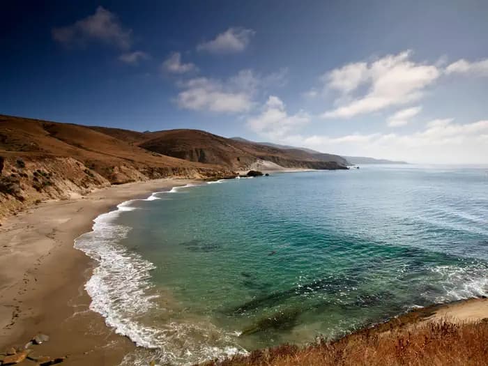
Backcountry beach camping is available mid-August through December along Santa Rosa Island's extensive, beautiful, and undeveloped 55-mile coastline. This coastline is reminiscent of California in days gone by. The rocky coast and sandy beaches are much the same as the ones the Chumash Indians, Spanish explorers, and early ranchers may have known. This remote, fragile environment is critical for sea and shorebirds, marine mammals, and plant communities.
In 1992, the National Park Service opened the island to backcountry beach camping in recognition of its rare wilderness values. As you explore these wild areas by kayak or on foot, please take responsibility to help us protect and preserve these delicate natural resources for future generations. The following information will help you enjoy your visit while leaving the smallest impact on the island.
Warning: While backcountry camping is an incredible experience, it is not for the inexperienced backpacker or kayaker. Due to difficult weather, rugged terrain, and off-trail hiking, backcountry camping is an arduous endeavor and should be undertaken only by experienced, well-conditioned backpackers and kayakers. Less experienced visitors to the island should consider frontcountry camping at Santa Rosa Island Campground in Water Canyon, which also offers advance reservations with some amenities (e.g., pit toilet, picnic table, water).
WAG Bags Required: Visitors are required to pack out human waste and toilet paper in the backcountry using "WAG" (human waste collection) bags. Visitors must bring there own bags which are available from outdoor suppliers.
Backcountry Beach Camping Dates
- January 1 - August 14: Backcountry beach camping is CLOSED to protect pupping seals/sea lions and nesting seabirds.
- August 15 - September 15: Only East Point to South Point Beaches (Southeast Quadrant) are open to backcountry camping for boaters, kayakers, and backpackers.
- September 16 - December 31: Southeast, Southwest, and Northwest Quadrant beaches are open to backcountry camping. Beaches around Sandy Point, at Lobo Canyon, and Northeast Quadrant beaches (between Carrington Point and East Point) remain closed to camping.
Recreation
Boat and Airplane Drop Off Points.
The park boat concessionaire, Island Packers, drops off and picks up kayakers and backpackers at the Bechers Bay pier. Campers should coordinate purchasing boat tickets in conjunction with making campground reservations.
There is currently no park airline concessionaire, private landings on the airstrip near Water Canyon, or anywhere else on the island, is prohibited.
Trail Conditions.
Hiking to beach camping areas requires travel along rugged exposed mountainous roads, trails, and unmaintained routes often created by island animals. Expect high winds and sunny conditions with no shade or cover. Navigating beaches and bluffs may be possible depending on ocean conditions and commonly require hiking across drainages and badlands. It is recommended to carry tide charts when navigating the beaches, coasts and bluffs. Some road/trail intersections have signs, some do not. Most trails and routes do not get you directly to a beach camping area, but instead end above a marine terrace/bluff or on top of a canyon and you must find the safest way down to the beach.
Maps.
Please refer to topographical maps for more accurate mileage and to help with the following descriptions. It is recommended that all backcountry campers have both digital and physical maps. Backpackers should carry topographic maps (USGS 7.5 minute maps or the Trails Illustrated map of all the islands) and kayakers carry nautical charts before departing on their journey.
Hiking and Kayaking Distances to Beach Camping Areas.
Backcountry campers should be prepared to hike 10+ miles (16 km+) on their first and last days in the backcountry regardless of itinerary. While some beaches are less than 10 miles away, you may arrive to find your destination beach unavailable (occupied by other campers, covered in pinnipeds, under water from high tides, etc.) and need to hike to the next available beach.
Southeast Quadrant (August 15-December 31)
East Point from Pier: 7 mi (11 km) hiking; 8 mi (13 km) kayaking*
East Point to Ford Point: 8 mi (13 km) hiking; 5 mi (8 km) kayaking**
Ford Point via South (Wreck) Road from Pier: 9 mi (14.5 km) hiking+
Ford Point to Johnsons Lee: 4 mi (6.5 km) hiking; 3.5 (6 km) kayaking+
Johnsons Lee (via East Point) from Pier: 18 mi (29 km) hiking; 16 mi (26 km) kayaking**
Johnsons Lee via Main (Soledad) Road from Pier: 14 mi (22.5 km) hiking+
Johnsons Lee via South (Wreck) Road from Pier: 13.5 mi (22 km) hiking+
La Jolla Vieja via South (Wreck) Road from Pier: 11.2 mi (18 km) hiking+
* Camping Just South of East Point is NOT Recommended. While no camping is allowed at East Point, there is a small pocket beach just to the south in the Southeast Quadrant. However, it is not recommended for camping as this beach is very, small and may be washed out at higher tides. In addition, pounding surf and strong winds constantly reshape this beach.
** Hiking Beyond East Point. If hiking beyond East Point to Ford Point, it is recommended that you follow the ridge line or road until you reach the northeast ridge of San Augustine Canyon. Follow this ridge down to the mouth of the canyon. Hiking along the beach from East Point to Ford Point is impossible due to section of vertical cliffs that drop directly into the ocean. However, kayakers can access beaches throughout this area. Once hikers reach Ford Point, they may follow the low terrace or higher ridge (both eventually run into a coastal road) down to the Johnsons Lee area. Refer to topographical maps for more information.
+ Direct access to beaches between Johnsons Lee and Ford Point (including La Jolla Vieja) is also possible via the Main (Soledad) or South (Wreck) roads. Both of these routes are long hikes and with a considerable amount of climbing and, once again, like all hiking or kayaking on the island, is recommended only for the experienced, well-conditioned traveler.
Southwest Quadrant (September 16-December 31)
Backcountry camping in the Southwest quadrant is extremely difficult and only recommended for experienced backpackers due to long distances, frequent high winds, and lack of reliable water sources. Be aware of closures and requirements to stay on routes in this area. There is no camping or beach access between China Camp and Cluster point OR around Sandy Point.
Trancion Canyon: 14 mi (22.5 km) hiking; 20 mi (32 km) kayaking++
Northwest Quadrant (September 16-December 31)
Backcountry camping in the Northwest quadrant is extremely difficult and only recommended for experienced backpackers due to long distances, frequent high winds, washed-out beaches at high tides, and lack of reliable water sources. Be aware of closures and requirements to stay on routes in this area. There is no camping between Carrington Point and Lobo Canyon.
Dry Canyon: 10 mi (16 km) hiking; 11 mi (17.7 km) kayaking++
Arlington Canyon: 12 mi (19.3 km) hiking; 12.5 mi (20 km) kayaking++
++Beginning September 16, the closest beach camping is Cow Canyon. However, this beach can wash out at high tide and/or large swell and is NOT recommended. Nearby Lobo Canyon beach is closed to beach camping and only available for day use. Therefore, Dry Canyon is the closest beach in the Northwest Quadrant that is recommended for camping.
Facilities
No facilities
This is primitive, dispersed, backcountry camping in tents with no established campsites nor electricity/water/sewer site hook-ups. Visitors must backpack to all locations and carry all of their own gear, food and water (see water information below).
Pack Out What You Pack In
Visitors are required to pack out what they pack in, including garbage and human waste. It is prohibited by law and regulation to leave human solid waste in the backcountry or in the wet intertidal sand. Human waste and toilet paper must be packed out for proper disposal using commercially available "waste bags".
Camp Only On Beaches
Visitors are required to camp on beaches. Camping is prohibited in any other areas, including coastal bluffs. Utilize sandy areas that are free of dune vegetation when hiking, landing water craft, and camping. Keep tents, kitchen areas, and traffic in "hardened" areas that are already bare from previous use. Do not damage live trees, plants, and other living things. It is not permitted to chop or nail trees, harvest or trample plants.
Water & Water Treatment
One gallon of water per person per day is recommended. Water weighs approximately 8 pounds per gallon. Potable water is available in the Water Canyon campground. During the backcountry camping season (mid-August through December), the only location outside the Water Canyon campground with an accessible, reliable water source is the Clapp Spring trough, approximately 7 miles from the pier [.6 miles south-southeast on Sierra Pablo Road from the intersection with South (Wreck) Road; 33°56’50” North, 120°03’19” West]. The water at Clapp Spring is safe to drink when boiled, filtered, or treated with iodine.
Although ten canyons may carry some degree of water intermittently throughout the year (except during dry years), water is not always available. Water found at the mouth of the canyons near beaches is likely to be brackish or dirty, walking up canyon for 5-10 minutes generally improves water quality. These ten canyons include: Water, Trancion, Bee, San Augustine, Wreck, Jolla Vieja, Arlington, Soledad, Cow, and Lobo. Water may be found in streams or stagnant pools, it can be thick with sediment and/or contaminated with coliform bacteria and giardia. Using a physical filter is recommended in addition to treating by boiling and/or using purification methods such as iodine.
Important Closures:
Year-round. Backcountry beach camping is prohibited between Lobo Canyon and East Point, between China Camp and Cluster Point, and all beaches around Sandy Point.
January 1 - August 14. All beaches are closed to backcountry beach camping to protect pupping seals/sealions and nesting seabirds.
August 15 - September 15. Northwest and northeast beaches are closed to camping. Only the Southeast Quadrant (East Point to South Point Beaches) is open to backcountry camping. From September 16 through December 31, all Southeast, Southwest, and Northwest Quadrant beaches are open to backcountry camping.
March 1 to September 15. Back beaches and sand dunes between and including Skunk Point to just north of East Point are closed to hiking to protect the nesting area for the snowy plover, a federally listed, threatened shorebird. Please remain on the wet sand (below mean high tide) or the throughout this area.
Additional Information
Please visit Backcountry Beach Camping: Santa Rosa Island on the Channel Islands National Park website for more information.
Natural Features
Weather
Weather conditions are generally best from August through October, with relatively calm wind and sea conditions and virtually no rain. Backpackers and kayakers should be prepared for strong northwest winds throughout the year, with the possibility of strong east or Santa Ana winds from October through January. The average wind speed is 15 knots, although speeds of 40 to 50 knots are not uncommon. Occasionally, the south side of the island (South Point to East Point) offers protection from these strong winds. Dense fog is common making chart and compass navigation mandatory. For the most current weather forecast, please visit Channel Islands National Marine Sanctuary's Internet Weather Kiosk .
Ocean Conditions
Kayakers may encounter strong ocean currents around the islands. Intense wave and surf conditions exist around the Carrington Point area. Sheer cliffs rise out of the ocean, reflecting incoming waves back out to sea, creating a washing machine effect. In this turbulent area there are no places to land, even in an emergency. The first landable beach is Lobo Canyon, five miles west of the ranch area pier. Rounding Skunk Point may be tricky as well because of merging currents. The wind often increases in the afternoon, and the prevailing northwesterlies can make paddling back to Water Canyon difficult. During the summer months, large swells often pound the south side of the island, making landing and launching from the beaches extremely challenging, requiring advanced skills. Ocean water temperatures range from the lower 50s (F) in the winter to the upper 60s (F) in the fall.
Rules and notices at Santa Rosa Island Backcountry Beach Camping
Recreation.gov does not date these notices. We last read them on September 28, 2026. Check Santa Rosa Island Backcountry Beach Camping on Recreation.gov
Notices from Recreation.gov
Reservations Required. Advance reservations are mandatory. There are no walk-ups.
Camping Maximum. Ten groups per night, per quadrant. Max 4 campers per group. One party or group may reserve a maximum of 2 sites per visit.
Transportation to the Island. You must arrange transportation to Santa Rosa Island before making a campsite reservation. Please read 'Getting There.'
Bring Extra Supplies. Bring supplies and food for an extra day in case the boats are unable to pick up campers due to weather conditions.
Backpack to Beach Camping Areas. Visitors must backpack to and from their dispersed campsites and must carry their own gear, food and water. The minimum hiking distance from the Bechers Bay Pier to an approved beach camping area is 7 miles (5.5 miles when all quadrants are open and with good conditions). Campers should be prepared to hike 10+ miles on their first and last day in the backcountry.
Check-in. Check-in with a ranger on arrival for an on-site orientation. Bring your confirmation email with you. Check-in and check-out times are at 11:00 a.m. Quiet time is enforced at 10:00 p.m.
Water & Water Treatment. The park recommends carrying one gallon of water per person per day. Potable water is available in the Water Canyon (frontcountry) campground. Outside the Water Canyon campground, water sources may be unreliable or contaminated. Please read the water and water treatment information under 'Facilities.'
Camp Only on Beaches. Camping is prohibited in any other areas, including dunes and coastal bluffs. Beach camping areas can fill (dry/usable space is limited and may be occupied by wildlife), many beaches are not accessible from land (cliffs), or do not have established/obvious trails to or from. Please read the additional details under 'Facilities,' above.
Proper food and trash storage is required. Recommend hard-sided container (i.e., bear canister) to further protect food/garbage from animals.
Pack In, Pack Out. Visitors are required to pack out what they pack in, including garbage and human waste in the backcountry. 'Waste bags' are available from outdoor suppliers. Strain or separate food particles from cooking water and pack them out. Scatter the gray water 200 ft. from water sources and camps.
No Campfires. No campfires or charcoal fires. Only enclosed gas camp stoves. Stoves only in authorized beach camping areas.
Smoking. Smoking is only allowed on beach areas far from ignition sources.
Hantavirus. Avoid contact with deer mice. Hantavirius has been found in island deer mice.
Biosecurity. To help prevent the introduction of nonnative species the following items may not be brought to the park: pets; live or potted plants; soil; cut flowers; firewood or any untreated, unfinished wood (including hiking sticks); corrugated boxes; tools or equipment with attached soil; motorized vehicles; bicycles; and single-use plastic grocery bags. Prior to departure, visitors are required to use pest-proof packing materials, inspect and clean their gear and shoes of all soil, seeds, and insects. Learn more about biosecurity and watch the required video at Protect Your Park Through Biosecurity .
Fishing . No fishing in marine reserves. A California fishing license and ocean enhancement required to fish within Channel Islands National Park.
Watersports . Due to the strong, persistent wind, swimming, snorkeling, diving, and kayaking are limited and recommended for the experienced visitor only. Ocean conditions can rapidly change, requiring expert abilities. Ocean kayaking is an inherently dangerous activity. Always check weather and do not kayak beyond your experience level.
Important Closures . Avoid closed areas to protect island resources. Island closures include but are not limited to:
•
Sandy Point - No camping or beach access.
•
Skunk Point - Travel on wet sand only. No camping.
•
China Camp and Cluster Point - No camping or beach access. Areas around China Camp and Cluster point are restricted to on trail travel only. Follow route and closure signs in area.
•
Lobo Canyon - No camping. Area is restricted to on trail travel only. Follow route and closure signs in area.
Everything is Protected As in all national parks, it is illegal to feed, collect, disturb, or harm park wildlife, plant life, or other natural, historical, and archeological features. Taking from or disturbing archeological sites or artifacts is a violation of state and federal law. The archeological sites around the Channel Islands are a testament to the importance of the Chumash and other American Indians. Archeological sites are sacred to Chumash peoples today, are protected by federal law, and are a vital nonrenewable scientific resource. Please help us in protecting and preserving this rich part of California’s heritage.
Additional Information . Please visit Backcountry Beach Camping: Santa Rosa Island on the Channel Islands National Park website for more information.
Santa Rosa Island Backcountry Beach Camping FAQ
How hard is it to get a campsite at Santa Rosa Island Backcountry Beach Camping?
Santa Rosa Island Backcountry Beach Camping is rated "Very Hard to Book" based on historical demand. This campground is popular and often books out weeks in advance. Your best strategy is to monitor cancellations.
How do I find last-minute availability at Santa Rosa Island Backcountry Beach Camping?
Cancellations happen frequently at Santa Rosa Island Backcountry Beach Camping, especially 1-2 weeks before check-in dates. PermitSnag monitors availability 24/7 and sends instant alerts when sites open up due to cancellations. This is often the best way to snag popular campsites.
How many campsites does Santa Rosa Island Backcountry Beach Camping have?
Santa Rosa Island Backcountry Beach Camping has 33 campsites.
More campgrounds in Channel Islands National Park
Same forest, same drive. Set an alert on any of them alongside this one.
- Anacapa Island campground availability16 sites
- San Miguel Island campground reservations19 sites
- is Santa Cruz Island del Norte Backcountry campground open9 sites
- Santa Cruz Island Prisoners Harbor campground availability7 sites
- Santa Rosa Island campground reservations16 sites
- is Santa Barbara Island campground open21 sites
Campgrounds
Browse Campsites
Monitor campsite availability across federal and state parks. Get alerts when sites open up at sold-out campgrounds.
California
8 popular campgrounds
- Atwell Mill Campground
- Buckeye Flat Campground
- Canyon View Group Sites
- Cold Springs Campground (Ca)
- Crystal Springs Campground (Ca)
- Crystal Springs Campground Mid-Sized Group Sites
- Death Valley Backcountry Roadside Camping
- Indian Cove Group Campground
Oregon
8 popular campgrounds
- Little Crater Lake Campground
- Cave Creek Campground
- Acorn Woman Lakes Campground
- Big Lake West Campground
- Bolan Lake Campground
- Cavitt Creek Falls Recreation Site
- Clearwater Falls Campground
- Cultus Lake Boat In - West Campground
Utah
8 popular campgrounds
- Canyonlands National Park Needles District Campground
- Devils Garden Campground
- Natural Bridges Campground
- North Campground (Ut)
- South Campground (Ut)
- Sunset Campground (Ut)
- Watchman Campground
- Anderson Meadow Campground (Fishlake NF, Ut)
Ohio
8 popular campgrounds
- Grand Lake St. Marys State Park Grand Lake West Bank Marina
- Kiser Lake State Park Kiser Lake Grandview Area Tie Ups Campground
- Lake Logan State Park Lake Logan Marina Beach 1-18 Campground
- Lake Loramie State Park Earls Island Dock Back Campground
- Pike Lake State Park Pike Lake Cabins and Day Use Shelters
- Scioto Trail State Park Stewart Lake Campground
- Buck Creek State Park G Dock Campground
- Buckeye Lake State Park Fairfield Beach a Docks Campground
Minnesota
8 popular campgrounds
- Cass Lake Loop Campground
- Fenske Lake Campground
- Glacial Lakes State Park Lower Campground
- Jeanette Lake Campground
- Lake Bronson State Park Lakeside Extension Campground
- Lake Maria State Park Backpack Campsites
- Lake Shetek State Park Prairie Campground
- Maplewood State Park Grass Lake Campground: Hollow Loop
One tick helps us more than you’d think
Google lets you pick the sites it highlights for you. Add PermitSnag and our campground pages get marked as one of yours in AI Overviews and AI Mode.
Takes less than a minute.