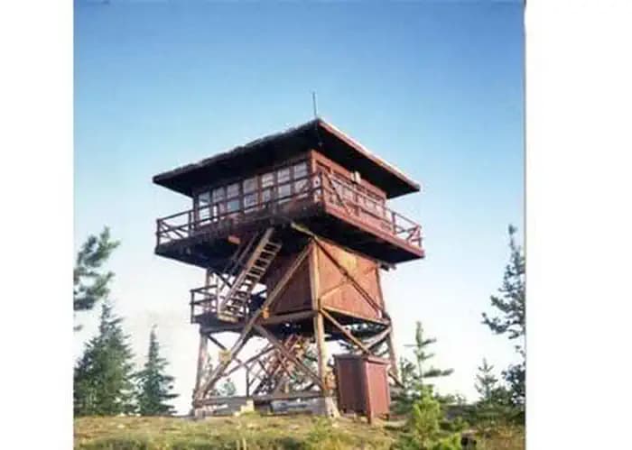
Surveyors Lookout
Idaho Panhandle National Forests, Idaho
Sold out? We check Surveyors Lookout for cancellations and email you the moment a site opens.
Cancellation alerts
Sold out for your dates?
Free to start. Email alerts included.
As of October 2026, Surveyors Lookout is a campground in Idaho Panhandle National Forests with 1 campsite. Surveyors Lookout is booked through Recreation.gov.
- PermitSnag checks Surveyors Lookout for availability and tells alert holders when a site opens up.
- Surveyors Lookout is located at 46.9942° N, 115.5333° W.
- people allowed on each site
- 4
Surveyors Lookout reservations and next available dates
October 2026
Campsites at Surveyors Lookout
- Cabin 1
Amenities
- restrooms
- potable water
At a glance: Setting: Mountain.
Things to do: fishing, hiking, climbing, photography, horse riding.
All sites at Surveyors Lookout, as listed by Recreation.gov
Every site is in the AREA SURVEYORS LOOKOUT loop.
| Site | Type | Sleeps |
|---|---|---|
| 001 | Cabin | 4 |
About Surveyors Lookout
Overview
Located near the Mallard-Larkins Pioneer Area Attractions, Surveyors Lookout is perched atop a 30 foot tower, providing phenomenal views of Snow Peak and the surrounding mountains. The cabin is listed on the National Historic Register for Lookouts and offers visitors a unique camping experience in the Idaho Panhandle National Forest.
The original pole structure lookout was built in 1931 as part of a network of lookouts used to spot fires in the Upper St. Joe Country. The original lookout was replaced with the current treated timber structure in 1964.
Access to the lookout is via a rugged single-lane road with pullouts, and is not recommended for low clearance vehicles. Road may be slick when wet.
Recreation
The Mallard-Larkins Pioneer Area straddles the divide between the Little North Fork Clearwater River basins and the North Fork Clearwater River. This beautiful area attracts hikers and some technical rock climbers. Hunting and trout fishing are offered in designated areas.
From the lookout, there is access to Scribner Falls Trail #106 and nearby access to Surveyor's Ridge Trail #40, Horseshoe Loop Trail #141, and Northbound Creek Trail #111.
A scenic drive through the upper St. Joe country is an excellent way to take in the sights leading up to the lookout.
Facilities
Surveyors Lookout can accommodate up to four guests. Furnishings include a propane cook stove, heater and lights. A twin bed and two extra mattresses are provided, along with a chest with some drawers. A refrigerator is also available, but it is very small and unreliable. It is recommended that guests bring a cooler with ice as backup. Cooking pots and utensils are included.
No drinking water is available; guests should bring plenty of their own. An alternate option is to collect water from a spring located 1.4 miles down the access road. This water is non-potable and must be boiled or treated before consuming.
Items to pack include food, bedding, a first aid kit, dish soap, towels, toiletries and binoculars. If planning to collect water from a stream, water containers are needed. Guests are advised to bring warm clothes and blankets for cold evenings. Although a heater is provided, the lookout is not insulated so it remains cold.
Natural Features
Surveyors Lookout is located atop Surveyors Ridge at an elevation of 6,000 feet. The 30 foot tower overlooks the spectacular Mallard-Larkins Pioneer Area, which straddles the divide between the Little North Fork Clearwater River basins and the North Fork Clearwater River. Snow Peak, Middle Sister and Mallard Peak Lookouts are still standing and can be seen from Surveyors.
Nearby Attractions
Avery is the nearest town for conveniences.
Rules and notices at Surveyors Lookout
Recreation.gov does not date these notices. We last read them on September 29, 2026. Check Surveyors Lookout on Recreation.gov
Notices from Recreation.gov
Entry is by combination lock; Pleaser refer to combination code on your confirmation.
No drinking water available; bring water or treat and boil spring water, found 1.4 miles down road
Please bring garbage bags; this is a 'pack it in-pack it out' facility
Wastewater should be strained and all food particles should be packed out; remaining water should be poured in a hole away from lookout
No smoking allowed in lookout
Please seal food in rodent-proof containers (one provided) or coolers
Bring plenty of blankets and warm clothes for cold nights
Click here for more information on the Idaho Panhandle National Forests
Don't Move Firewood: Prevent the spread of tree-killing pests by obtaining firewood near your destination and burning it on-site. For more information visit dontmovefirewood.org.
Surveyors Lookout FAQ
How hard is it to get a campsite at Surveyors Lookout?
Surveyors Lookout is rated "Hard to Book" based on historical demand. This campground is popular and often books out weeks in advance. Your best strategy is to monitor cancellations.
How do I find last-minute availability at Surveyors Lookout?
Cancellations happen frequently at Surveyors Lookout, especially 1-2 weeks before check-in dates. PermitSnag monitors availability 24/7 and sends instant alerts when sites open up due to cancellations. This is often the best way to snag popular campsites.
How many campsites does Surveyors Lookout have?
Surveyors Lookout has 1 campsites.
More campgrounds in Idaho Panhandle National Forests
Same forest, same drive. Set an alert on any of them alongside this one.
- Arid Peak Lookout availability1 site
- Avery Creek Cabin reservations1 site
- is Beaver Creek a-Frame Cabin (Id) campground open1 site
- Bell Bay Campground availability16 sites
- Berlin Flats campground reservations1 site
- is Deer Ridge Lookout open1 site
Campgrounds
Browse Campsites
Monitor campsite availability across federal and state parks. Get alerts when sites open up at sold-out campgrounds.
Idaho
8 popular campgrounds
- Montpelier Canyon Campground
- Warm Lake Campground
- Williams Lake Campground
- Albeni Cove Campground
- Alturas Lake Inlet Campground
- Amanita Campground
- Antelope (Boise National Forest, Id) Campground
- Bell Bay Campground
California
8 popular campgrounds
- Atwell Mill Campground
- Buckeye Flat Campground
- Canyon View Group Sites
- Cold Springs Campground (Ca)
- Crystal Springs Campground (Ca)
- Crystal Springs Campground Mid-Sized Group Sites
- Death Valley Backcountry Roadside Camping
- Indian Cove Group Campground
Oregon
8 popular campgrounds
- Little Crater Lake Campground
- Cave Creek Campground
- Acorn Woman Lakes Campground
- Big Lake West Campground
- Bolan Lake Campground
- Cavitt Creek Falls Recreation Site
- Clearwater Falls Campground
- Cultus Lake Boat In - West Campground
Utah
8 popular campgrounds
- Canyonlands National Park Needles District Campground
- Devils Garden Campground
- Natural Bridges Campground
- North Campground (Ut)
- South Campground (Ut)
- Sunset Campground (Ut)
- Watchman Campground
- Anderson Meadow Campground (Fishlake NF, Ut)
Ohio
8 popular campgrounds
- Grand Lake St. Marys State Park Grand Lake West Bank Marina
- Kiser Lake State Park Kiser Lake Grandview Area Tie Ups Campground
- Lake Logan State Park Lake Logan Marina Beach 1-18 Campground
- Lake Loramie State Park Earls Island Dock Back Campground
- Pike Lake State Park Pike Lake Cabins and Day Use Shelters
- Scioto Trail State Park Stewart Lake Campground
- Buck Creek State Park G Dock Campground
- Buckeye Lake State Park Fairfield Beach a Docks Campground
Minnesota
8 popular campgrounds
- Cass Lake Loop Campground
- Fenske Lake Campground
- Glacial Lakes State Park Lower Campground
- Jeanette Lake Campground
- Lake Bronson State Park Lakeside Extension Campground
- Lake Maria State Park Backpack Campsites
- Lake Shetek State Park Prairie Campground
- Maplewood State Park Grass Lake Campground: Hollow Loop
One tick helps us more than you’d think
Google lets you pick the sites it highlights for you. Add PermitSnag and our campground pages get marked as one of yours in AI Overviews and AI Mode.
Takes less than a minute.