Inyo NF Wilderness Permit — Mt Whitney Trail Crest Exit
Inyo National Forest · California
The exit quota for trips finishing at Whitney Portal. Your permit must name "Mt Whitney (Trail Crest Exit)" as the exit point, a separate quota from the entry permit reserved at your starting trailhead.
Get an alert when Mt Whitney Trail Crest Exit opens on your dates.
When it opens
- 6 months
- First come, first served from six months before your entry date, at 7 am Pacific60% of quota (15 of 25 spaces)You book on Recreation.gov.
- 2 weeks
- First come, first served from two weeks before your entry date, at 7 am Pacific40% of quota (10 of 25 spaces)You book on Recreation.gov.
Source: recreation.gov
70% of the openings our scanner caught on Mt Whitney Trail Crest Exit were gone within 10 minutes.
Mt Whitney Trail Crest Exit reservation dates
- Season
- May 1 to November 1
- max group size
- 15people
Mount Whitney has several separate permits for different routes and trip lengths. See the Mt. Whitney permit page.
This is one of many Inyo National Forest permits.
How to get a Mt Whitney Trail Crest Exit permit
As of September 2026, Mt Whitney Trail Crest Exit in Inyo National Forest, California requires a permit issued via reservation. Mt Whitney Trail Crest Exit is a high-demand permit, rating 8/10 on PermitSnag's demand index. Cancelled Mt Whitney Trail Crest Exit permits are re-released on the booking system, and PermitSnag alerts you the moment one opens. The permit season for Mt Whitney Trail Crest Exit runs May 1 through November 1.
- Type
- Overnight
- Location
- Eastern Sierra, CA
Step 1: Create an account before permits drop
Find this permit on the managing agency's booking system and set up an account with your payment info ready.
Step 2: Know the release schedule
Permits release on a rolling basis. Check the release time for your dates.
Step 3: Be ready when permits drop
Log in a few minutes early. Have your dates, group size, and payment ready to go.
Step 4: Monitor for cancellations
If your dates are sold out, people cancel all the time. Set up PermitSnag alerts to catch openings instantly.
Mt Whitney Trail Crest Exit pro tips
- Add Trail Crest as your exit point when you first book, not afterwards
- Take the pack-out kit seriously. There is a disposal box at the Portal restroom and no alternative on the trail
- Empty your car completely at the Portal and use the bear lockers, since bear activity there is high
- Cross the crest early in the day. The summit ridge is the last place you want to be in an afternoon storm
- There are no trees in the Whitney canyon suitable for hanging food, so a hard container is the only option
More on Mt Whitney Trail Crest Exit: Live availability activityWhen Mt Whitney Trail Crest Exit permits open upChance of an opening
How much a Mt Whitney Trail Crest Exit permit costs
Mt Whitney Trail Crest Exit permit fee: Recreation.gov permit 233262 lists a $6 Inyo reservation fee plus a per-person fee, shown as $5 for Inyo trailheads and $15 per person for Mt. Whitney.
The Mt Whitney Trail Crest Exit hike
- Route Type
- Point to Point
- Duration
- 1-2 days from the crest
- Difficulty
- Strenuous
Mt Whitney Trail Crest Exit landmarks
- 1Trail Crest
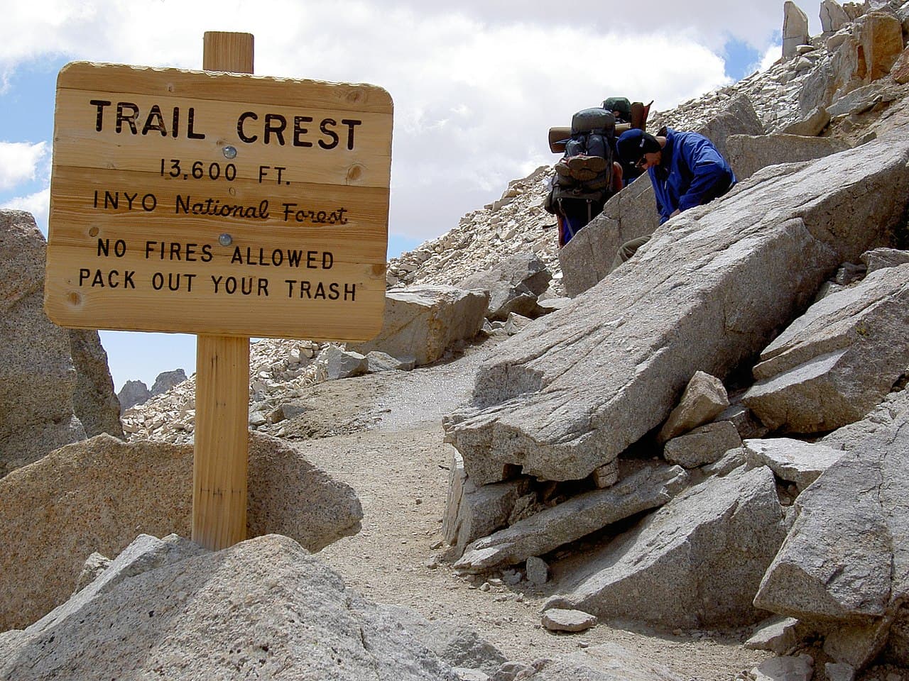
Inyo's stated elevation. Two miles from the summit, where the Whitney trail meets the John Muir Trail.
- 2Mount Whitney summit
Two miles from Trail Crest, per Inyo. Optional on this exit.
- 3Whitney Portal
The road end the exit quota is measured against, with bear lockers and a used-kit disposal box.
Not a way in, a way out. Trail Crest is the exit quota for anyone finishing a Sierra trip by walking down the Mount Whitney trail to the road.
About this permit
Mt. Whitney (Trail Crest Exit) is an Inyo National Forest exit quota rather than a normal entry trailhead. Inyo applies it to visitors who descend the Mount Whitney trail to Whitney Portal Road, and it is the option John Muir Trail hikers select when their trip finishes at the Portal.
Inyo states that exiting via Trail Crest allows you the option to hike to the summit of Mount Whitney and camp along the Mount Whitney trail as you finish your trip. Hikers who begin their trip in another park or forest are exempt from this exit quota, since the permit issued by the entry location is valid to visit Mount Whitney.
The forest's quota season runs May 1 to November 1 in 2026, with reservations opening six months in advance at 7 am Pacific and additional permits released two weeks ahead.
The route
Inyo puts Trail Crest at about 13,600 feet, two miles from the summit of Mount Whitney, where the Mount Whitney trail crosses the crest of the Sierra Nevada to join the John Muir Trail in Sequoia National Park.
The exit quota is what this permit reserves. Inyo notes that hikers who begin their trip in another park or forest are exempt from this exit quota, and that the permit issued by your entry location is valid to visit Mount Whitney. In practice, a JMT hiker starting on Inyo ground selects Trail Crest as the exit point on their entry permit.
The Whitney zone carries its own rules. All Mount Whitney visitors are expected to pack out their solid human waste, and Inyo provides pack-out kits with wilderness permits, with a disposal box next to the trailhead restroom. Stock is not allowed from Trail Crest to Whitney Portal, and there are no campfires.
Why it matters
Inyo National Forest manages Whitney's east side by counting people leaving as well as arriving. Inyo states the Trail Crest exit quota applies to visitors who descend the Mt. Whitney trail to Whitney Portal Road, and that exiting via Trail Crest allows you the option to hike to the summit of Mt Whitney and camp along the Mt Whitney trail as you finish your trip. For John Muir Trail hikers, this is the box you tick at booking.
The feeling
You come up the west side on tired legs, top out on the John Muir Trail junction, and then walk the last two miles of ridge to the highest point in the lower 48. The descent from Trail Crest is the famous set of switchbacks down to the Portal, and it is a long way down.
Mt Whitney Trail Crest Exit hike highlights
- An exit quota, selected on the permit for your entry trailhead
- Trail Crest at about 13,600 feet, two miles from the summit, per Inyo
- The option to summit Mount Whitney and camp along the Whitney trail on the way out
- Mandatory pack-out of solid human waste, with kits provided with the permit
- Bear lockers at the Portal parking and a used-kit disposal box by the trailhead restroom
How hard the Mt Whitney Trail Crest Exit hike is
- Physical DemandFitness and endurance required4/5
- Technical SkillClimbing, scrambling, or specialized skills2/5
- Exposure RiskSteep dropoffs and fall potential4/5
- NavigationRoute finding and trail clarity1/5
- CommitmentDifficulty of bailing out mid-route4/5
Best for: John Muir Trail hikers and other long-trip parties whose route ends by descending to Whitney Portal.
Recommended experience: Acclimatization from several days at altitude, which most parties arriving over Trail Crest already have.
Not recommended for: Anyone looking for a Whitney day hike or a standard eastside overnight, both of which are different permits.
When to hike Mt Whitney Trail Crest Exit
Best time to visit
The quota season runs May 1 to November 1. Most parties exit over Trail Crest between mid-July and September, when the switchbacks are clear of snow. Early and late season can mean snow and ice on the traverse below the crest.
- Peak
- Mid-July through September
- Shoulder
- Late June and October
Summer
Switchbacks clear, hot at the Portal, afternoon storms on the crest.
Crowd level · extreme
- Advantage: Snow-free descent to the Portal
- Advantage: Long days for a summit detour
- Advantage: Full services in Lone Pine
- Challenge: The busiest ground in the Sierra
- Challenge: Daily thunderstorm risk on the exposed summit ridge
- Challenge: Heavy bear pressure at the Portal
Fall
Cold and clear, with the quota season running to November 1.
Crowd level · high
- Advantage: Cooler descent
- Advantage: Fewer people on the summit ridge
- Advantage: Stable weather windows
- Challenge: Ice on the switchbacks after the first storms
- Challenge: Very cold at 13,600 feet
- Challenge: Short days for a long exit
Weather Forecast
Trailhead (5,000 ft)
Today
73°
55°
Tue
81°
50°
Wed
87°
56°
Thu
90°
62°
Fri
90°
64°
Sat
89°
67°
Sun
88°
66°
Mt Whitney Trail Crest Exit photography guide
Golden Hour
Sunrise from the summit ridge between Trail Crest and the top, with the Owens Valley 10,000 feet below.
Best Light
Late afternoon looking back up at the switchbacks from the Trail Camp basin.
Beat the Crowds
Cross Trail Crest early. The Portal-side day hikers reach the summit ridge from mid-morning onward.
Classic Shots
- The keyhole windows on the summit ridge looking east
- Trail Crest itself with the John Muir Trail dropping west
- The switchbacks stacked below the crest
Mt Whitney Trail Crest Exit rules, gear and safety
Gear checklist
Required- A bear-proof container, because Inyo notes there are no trees in this canyon suitable for hanging food
- The pack-out kit issued with your permit, plus a way to carry it
- Warm and windproof layers for a 13,600-foot crest crossing
- A headlamp for a long descent to the Portal
- Trekking poles for the switchbacks below Trail Crest
Rules & regulations
- 01All Mount Whitney visitors are expected to pack out their solid human waste, and pack-out kits are provided with the permit
- 02No campfires in the Mount Whitney area
- 03Stock is not allowed from Trail Crest to Whitney Portal
- 04Bear-proof containers must be used to store all food and refuse, since there are no trees in this canyon suitable to hang food
- 05All food and scented items must be removed from vehicles and stored in the bear-proof lockers in the parking areas
- 06Maximum group size is 15
- 07Special approval is required for commercial use
Hazards & considerations
- Altitude at Trail Crest and the summit, which is the most common reason parties turn around
- Afternoon lightning on a completely exposed ridge between Trail Crest and the summit
- A very long descent to the Portal at the end of a multi-day trip
- High bear activity in the Mount Whitney area, including in the parking lots
Safety & planning
Emergency Info
Emergency contacts, ranger station locations, and satellite communicator tips for Mt Whitney Trail Crest Exit.
Food Storage
Bear canister requirements, approved container lists, and rental locations for this permit.
Gear Checklist: Required and recommended gear for Mt Whitney Trail Crest Exit · Shuttle Services: Trailhead transportation options · Guide Services: Experienced wilderness guides
Some links may be affiliate links. Purchases support PermitSnag at no extra cost to you.
Mt Whitney Trail Crest Exit FAQ
What is the Mt. Whitney Trail Crest Exit permit for?
It is an exit quota. Inyo National Forest applies it to visitors who descend the Mount Whitney trail to Whitney Portal Road, so it is what John Muir Trail hikers select when their trip finishes at the Portal.
Do I need a separate Mount Whitney permit if I start my trip elsewhere?
No. Inyo states that hikers who begin their trip in another park or forest are exempt from the Trail Crest exit quota, and the permit issued by your entry location is valid to visit Mount Whitney.
How far is the Mount Whitney summit from Trail Crest?
Inyo puts Trail Crest at about 13,600 feet and two miles from the summit, where the Mount Whitney trail crosses the Sierra crest to join the John Muir Trail in Sequoia National Park.
Do I have to pack out human waste on the Mount Whitney trail?
Yes. Inyo states all Mount Whitney visitors are expected to pack out their solid human waste. Pack-out kits are provided with wilderness permits and there is a disposal box next to the trailhead restroom.
Mt Whitney Trail Crest Exit trail conditions and trip reports
Trail Conditions
No active conditions reported
Sign in to report trail conditions.
Questions
No questions yet
Be the first to ask about Mt Whitney Trail Crest Exit.
Trip Reports
Write ReportNo trip reports yet
Be the first to share your experience at Mt Whitney Trail Crest Exit.
Write the First ReportAlternatives to a Mt Whitney Trail Crest Exit permit
- Similar ExperiencePermit required
Mt. Whitney Trail (Overnight)
The standard eastside overnight permit up the Whitney trail from the Portal, awarded through the Whitney lottery.
Tradeoffs
A far simpler trip, but it goes through the lottery rather than an exit quota.
- Same AreaPermit required
North Fork of Lone Pine Creek
The Mountaineers Route approach, climbing the Ebersbacher Ledges to Boy Scout and Iceberg Lakes.
Tradeoffs
A route with real scrambling and no maintained trail to the summit.
- Easier AlternativePermit required
Cottonwood Pass
The gentle southern approach from Horseshoe Meadows toward Crabtree and Whitney's west side.
Tradeoffs
Much easier permits and a kinder grade, at the cost of several extra days.
Where to stay near Mt Whitney Trail Crest Exit
- Pleasant Valley Pit CampgroundAlabama Hills
- Horton Creek CampgroundAlabama Hills
- Four Jeffrey campgroundInyo National Forest
- All California campgrounds
Plan the full trip, not just the permit
Build your full itinerary start to finish
Add your dates and get a day-by-day plan: what needs a permit, what gear to bring, and one link to share with your whole group to coordinate every step.
No permit needed to start
One tick helps us more than you’d think
Google lets you pick the sites it highlights for you. Add PermitSnag and our permit pages get marked as one of yours in AI Overviews and AI Mode.
Takes less than a minute.