Skip to content
Guadalupe Mountains Wilderness Permit permit area in Guadalupe Mountains National Park - backcountry hiking destination
Booked one camp per night, in order

Guadalupe Mountains Wilderness Permit

Guadalupe Mountains National Park · Texas

Required for every overnight in the Guadalupe Mountains Wilderness. Ten designated campgrounds, four people per permit, and every drop of water carried up from the trailhead.

Get an alert when a night opens on your Guadalupe Wilderness dates.

Get alerts for your Guadalupe Wilderness nights

A Guadalupe Wilderness reservation is a sequence of nights, and each night books a camp.

Give us your trip window and we check every night of it across all camps on this permit, then tell you the moment nights open.

Cover the whole trip, plus any spare days you could shift onto. A wider window catches more openings.

The window above is how much time you have to work with. This is how many nights the trip itself takes. Leave it blank and we'll check every night in the window. We alert you when 2 or more nights in a row open.

Party

This permit allows up to 4 people per group.

When it opens

3 months
First come, first served from three months before your entry dateYou book on Recreation.gov.

Source: recreation.gov

70% of the openings our scanner caught on Guadalupe Wilderness were gone within 10 minutes.

Guadalupe Wilderness reservation dates

Season
October 1 to November 26
route distance, out and back
3mi
elevation gain
2,000ft
max group size
4people

How to get a Guadalupe Wilderness permit

As of September 2026, Guadalupe Wilderness in Guadalupe Mountains National Park, Texas requires a permit issued via reservation. Guadalupe Wilderness rates 5/10 on PermitSnag's demand index. Cancelled Guadalupe Wilderness permits are re-released on the booking system, and PermitSnag alerts you the moment one opens. The permit season for Guadalupe Wilderness runs October 1 through November 26. The Guadalupe Wilderness route covers 3 miles with 2,000 feet of elevation gain, rated strenuous.

Type
Backpacking
Location
Chihuahuan Desert, TX
  1. Step 1: Create a Recreation.gov account

    Sign up at Recreation.gov if you don't have an account. Have your payment info ready.

  2. Step 2: Know the release schedule

    Permits release on a rolling basis. Check the release time for your dates.

  3. Step 3: Be ready when permits drop

    Log in a few minutes early. Have your dates, group size, and payment ready to go.

  4. Step 4: Monitor for cancellations

    If your dates are sold out, people cancel all the time. Set up PermitSnag alerts to catch openings instantly.

Guadalupe Wilderness pro tips

  1. The reservation is not the permit. If you cannot reach Pine Springs Visitor Center by 3:30 PM Mountain Time, you do not get to camp.
  2. Water weight is what limits most people to one or two nights. Plan the trip around the gallon per person per day, not the mileage.
  3. Dog Canyon is a few miles over the ridge from Pine Springs and about two hours away by road. Do not plan a car shuttle casually.
  4. Book fall color weekends the day the three month window opens. Peak season runs October 1 through November 26.

More on Guadalupe Wilderness: Live availability activityWhen Guadalupe Wilderness permits open up

How much a Guadalupe Wilderness permit costs

Guadalupe Wilderness permit fee: $6 reservation fee + $6 per person per night.

The Guadalupe Wilderness hike

Distance
3 miles
Elevation Gain
2,000 ft
Route Type
Out & Back
Duration
1-3 nights
Difficulty
Strenuous

Guadalupe Wilderness landmarks

  1. 1Pine Springs Visitor Center

    Where every reserved permit must be picked up in person, by 3:30 PM Mountain Time.

  2. 2Pine Springs Trailhead

    Main access for Guadalupe Peak, Pine Top, Tejas and the Bowl.

  3. 3Guadalupe Peak Campground

    Designated campground below the highest point in Texas.

  4. 4Pine Top Campground

    First designated campground above Pine Springs and the usual first night.

  5. 5The Bowl

    The conifer forest on top of the range, an island of ponderosa and Douglas fir above the desert.

  6. 6McKittrick Canyon Trailhead

    Fall color access and the bottom of the McKittrick Ridge climb.

  7. 7McKittrick Ridge Campground

    High designated campground above McKittrick Canyon, reached by the steepest sustained climb in the park.

  8. 8Dog Canyon Trailhead

    North side access from New Mexico State Road 137, closest to Marcus and Mescalaro.

Climb 2,000 feet out of the desert with three days of water on your back and sleep on a fossil reef that was a Permian sea floor.

About this permit

Guadalupe Mountains requires a wilderness use permit for every overnight in the wilderness. Backpackers choose from 10 designated campgrounds with 60 campsites between them, and the Park Service states each campground requires a minimum of three miles and two thousand feet of elevation gain to reach.

The reservation is not the permit. You must pick the permit up in person at the Pine Springs Visitor Center by 3:30 PM Mountain Time, up to 48 hours before your trip starts, with photo identification. Walk-up permits for unreserved sites are issued at Pine Springs from 8:00 a.m. to noon daily. Reservations open three months in advance and permits are available year round.

The route

Ten designated campgrounds hold 60 campsites between them, and the Park Service says every one requires a minimum of three miles and two thousand feet of elevation gain to reach. There is no easy first night here.

From Pine Springs the Tejas and Bush Mountain trails climb to Pine Top, Tejas, Bush Mountain and Blue Ridge, which chain together into the classic two and three night loops over the top of the range. Guadalupe Peak has its own campground below the highest point in Texas.

McKittrick Canyon is the fall color trailhead and McKittrick Ridge sits high above it, a long steep climb that people rate as the hardest in the park. Dog Canyon comes in from the New Mexico side and puts you closest to Marcus and Mescalaro.

Why it matters

The Guadalupes are the most complete exposed fossil reef on earth and they rise straight out of one of the emptiest corners of Texas. The park is honest about the trade: there is no water in the mountains, none, which is why most trips here are one or two nights and why the campgrounds stay quiet even in fall color season.

The feeling

The climb out of Pine Springs is relentless switchbacks with the whole Chihuahuan Desert opening up behind you and the wind picking at your pack. Then you top out and the ridge is covered in ponderosa and Douglas fir, an island forest a thousand miles from anything like it. At night the lights of El Paso are a faint smudge 110 miles west.

Guadalupe Wilderness hike highlights

  1. 10 designated campgrounds holding 60 campsites total
  2. A minimum of three miles and two thousand feet of gain to reach any of them
  3. No water in the mountains at all. Water exists only at Pine Springs, McKittrick Canyon and Dog Canyon
  4. A maximum of four people and seven nights per permit
  5. Mandatory in-person permit pickup at Pine Springs by 3:30 PM Mountain Time

How hard the Guadalupe Wilderness hike is

  • Physical DemandFitness and endurance required4/5
  • Technical SkillClimbing, scrambling, or specialized skills1/5
  • Exposure RiskSteep dropoffs and fall potential2/5
  • NavigationRoute finding and trail clarity2/5
  • CommitmentDifficulty of bailing out mid-route3/5

Best for: Backpackers willing to carry two or three days of water up 2,000 feet, on real trails, for a quiet ridge nobody else is on.

Recommended experience: One prior trip carrying a heavy pack uphill. The trails are maintained, so the difficulty is load and grade, not skill.

Not recommended for: Anyone who wants water on route, or who cannot reach Pine Springs Visitor Center by 3:30 PM the day before or day of.

Trailhead information

Pine Springs

Primary

Main trailhead and the only place reserved permits can be picked up.

  • Restrooms
  • Water on site
  • Weak Signal

Before you rely on this water

Water is available at Pine Springs, McKittrick Canyon and Dog Canyon. There is no water anywhere in the mountains, so plan for one gallon per person per day carried up.

Parking

Your permit does not guarantee a parking spot. Lots fill early on peak days and the park encourages carpooling.

Getting There

On US Highway 62/180, 110 miles east of El Paso and 56 miles southwest of Carlsbad, New Mexico.

Nearest Services

Whites City and Carlsbad, New Mexico to the northeast, or Van Horn 62 miles south.

Trailhead information

McKittrick Canyon

Alternate

Fall color trailhead and the start of the McKittrick Ridge climb.

  • Restrooms
  • Water on site
  • No Service

Before you rely on this water

Water at the McKittrick Canyon contact station only. Nothing above it.

Parking

Gated lot with posted hours. Confirm the gate schedule before planning a late exit.

Getting There

Signed turnoff from US 62/180 northeast of Pine Springs.

Nearest Services

Carlsbad, New Mexico.

Trailhead information

Dog Canyon

Alternate

North side trailhead reached from New Mexico, closest to Marcus and Mescalaro.

  • Restrooms
  • Water on site
  • No Service

Before you rely on this water

Water at the Dog Canyon ranger station. None on the trails above.

Parking

Small lot at the ranger station and campground.

Getting There

New Mexico State Road 137 south from Carlsbad. Roughly two hours from Pine Springs by road even though it is a few miles over the ridge.

Nearest Services

Carlsbad, New Mexico.

When to hike Guadalupe Wilderness

Best time to visit

October and November for fall color, which the park lists as peak season from October 1 through November 26. Spring break from late February through late April is the other busy window and comes with the wind.

Peak
October 1 through November 26
Shoulder
September and early December
  • Spring

    Spring break brings the second crowd peak, and the wind season overlaps it.

    Crowd level · high

    • Advantage: Long days
    • Advantage: Comfortable temperatures early in the season
    • Challenge: Wind through April 30
    • Challenge: High fire risk from March 1
    • Challenge: Heat building by May
  • Summer

    Hot at the trailheads and dry everywhere. Few backpackers.

    Crowd level · low

    • Advantage: Wide open campground availability
    • Challenge: Heat on the climbs
    • Challenge: High fire risk
    • Challenge: Water weight becomes the whole trip
  • Fall

    The best conditions of the year and the busiest. McKittrick Canyon color peaks in this window.

    Crowd level · extreme

    • Advantage: Cool climbing temperatures
    • Advantage: Bigtooth maple color
    • Advantage: Longest stable weather windows
    • Challenge: Parking lots fill early
    • Challenge: Campgrounds book out for color weekends
  • Winter

    Cold and very windy. The park publishes gusts from 30 to 80+ mph for the season.

    Crowd level · low

    • Advantage: Empty campgrounds
    • Advantage: Cool enough to carry heavy water
    • Challenge: Sustained high wind
    • Challenge: Freezing nights on the ridge
    • Challenge: Occasional snow and ice

Weather Forecast

Trailhead (5,000 ft)

⚠️

Backcountry Tips

  • Today: 87% chance of precipitation. Pack rain gear.
  • Tomorrow: Wind gusts to 44mph. Secure tent, avoid exposed ridges.
  • Windy conditions: Bring wind-resistant shelter if camping.

Today

🌧️

64°

56°

87%

Wed

🌧️

59°

48°

46%

Thu

🌫️

57°

45°

Fri

☁️

53°

46°

Sat

🌧️

59°

46°

Sun

🌧️

58°

49°

Mon

🌧️

59°

49°

23%

View full NWS forecast →Mountain weather changes rapidly. This forecast is a guide—always be prepared for worse conditions.

Guadalupe Wilderness photography guide

Golden Hour

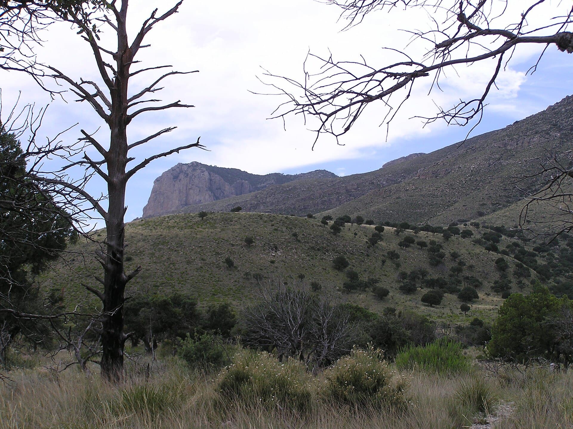
Late afternoon on El Capitan from the Pine Springs side, when the reef face goes gold against a darkening sky.

Best Light

McKittrick Canyon color peaks in late October and early November and photographs best in flat morning light before the canyon wind starts.

Beat the Crowds

Everyone day hikes Guadalupe Peak and McKittrick Canyon. Camp at Blue Ridge or Marcus and you will not see anybody.

Classic Shots

  1. El Capitan from the Guadalupe Peak trail switchbacks
  2. Bigtooth maples turning in McKittrick Canyon
  3. The Bowl's conifer forest with desert visible through the gap
  4. Sunset over the salt flats from the high ridge

Guadalupe Wilderness rules, gear and safety

Gear checklist

Required
  • One gallon of water per person per day, all of it carried up from the trailhead
  • Wind-worthy shelter. Gusts from 30 to 80+ mph are published for the November through April season
  • Warm layers, because the ridge is thousands of feet above the desert floor
  • Photo ID for permit pickup
  • Stove, since the range is under high fire risk from March through September

Recommended gear

  • Extra water bladder, because water weight is the factor that limits most trips here to one or two nights
  • Trekking poles for the sustained 2,000 foot climbs
  • Satellite messenger. Cell phones have limited coverage and search and rescue is discretionary
  • Buff or bandana for blowing grit on the ridge

Rules & regulations

  1. 01A wilderness use permit is required for every overnight in the wilderness
  2. 02Each permit is limited to a maximum of four persons and seven nights. Larger groups split into fours with a different leader per permit
  3. 03The reservation is not the permit. Pick it up in person at Pine Springs Visitor Center by 3:30 PM Mountain Time, up to 48 hours before your start
  4. 04Photo identification is required to collect the permit
  5. 05Walk-up permits for unreserved sites are issued at Pine Springs from 8:00 a.m. to noon, up to 24 hours in advance
  6. 06Your permit does not guarantee a parking spot, and lots fill early during peak visitation
  7. 07Over 96% of the recreation fee goes directly to park projects

Hazards & considerations

  • No water in the mountains, which is the single defining hazard of this park
  • High winds from November 30 through April 30, with gusts published from 30 to 80+ mph
  • High fire risk from March 1 through September 30
  • Weather that is highly variable even day to day
  • Limited cell coverage, and the park states that search and rescue is discretionary
  • Sustained steep climbs on every route into the wilderness

Safety & planning

Emergency Info

Emergency contacts, ranger station locations, and satellite communicator tips for Guadalupe Wilderness.

Food Storage

Bear canister requirements, approved container lists, and rental locations for this permit.

Gear Checklist: Required and recommended gear for Guadalupe Wilderness · Shuttle Services: Trailhead transportation options · Guide Services: Experienced wilderness guides

Some links may be affiliate links. Purchases support PermitSnag at no extra cost to you.

Guadalupe Wilderness FAQ

How do I get a Guadalupe Mountains wilderness permit?

Reserve on Recreation.gov permit 4675328 up to three months ahead, then pick the permit up in person at the Pine Springs Visitor Center by 3:30 PM Mountain Time, up to 48 hours before your trip. The reservation alone is not a permit.

Is there water on a Guadalupe Mountains wilderness permit trip?

No. The Park Service states there is no water available in the Guadalupe Mountains and all users must carry in their water, planning for one gallon per person per day. Water is available only at Pine Springs, McKittrick Canyon and Dog Canyon.

How many people can be on a Guadalupe Mountains wilderness permit?

Four. Each wilderness use permit is limited to a maximum of four persons and seven nights, and larger groups must divide into fours with a different group leader for each permit.

Can I get a walk-up Guadalupe Mountains wilderness permit?

Yes, for unreserved sites. Walk-up permits are issued at the Pine Springs Visitor Center from 8:00 a.m. to noon daily, up to 24 hours in advance of the trip.

How much does a Guadalupe Mountains wilderness permit cost?

A $6 non-refundable reservation fee plus a $6 per person per night recreation fee. Park entry requires a separate fee or pass.

Guadalupe Wilderness trail conditions and trip reports

Trail Conditions

No active conditions reported

Sign in to report trail conditions.

Questions

No questions yet

Be the first to ask about Guadalupe Wilderness.

Trip Reports

Write Report

No trip reports yet

Be the first to share your experience at Guadalupe Wilderness.

Write the First Report

Alternatives to a Guadalupe Wilderness permit

  • Same AreaPermit required

    Big Bend backcountry

    The other west Texas desert backcountry permit, with the Chisos high country as the equivalent trip.

    Tradeoffs

    Five hours south, but a bigger park with more route options and the same carry-your-water rule.

  • Similar ExperiencePermit required

    Death Valley Cottonwood-Marble loop

    Desert wilderness with seasonal springs instead of nothing at all.

    Tradeoffs

    Longer and lower with a 4x4 approach, but you are not carrying every drop.

  • Similar ExperiencePermit required

    Great Sand Dunes backcountry

    Colorado sand and mountain permit with at-large camping and a published daily cap.

    Tradeoffs

    Cooler and higher, and no in-person pickup requirement.

Where to stay near Guadalupe Wilderness

Plan the full trip, not just the permit

Build your full itinerary start to finish

Add your dates and get a day-by-day plan: what needs a permit, what gear to bring, and one link to share with your whole group to coordinate every step.

Plan a trip here

No permit needed to start

One tick helps us more than you’d think

Google lets you pick the sites it highlights for you. Add PermitSnag and our permit pages get marked as one of yours in AI Overviews and AI Mode.

Add PermitSnag in Google

Takes less than a minute.