Skip to content
Enchanted Valley Permit permit area in Olympic National Park - backcountry hiking destination
Booked one camp per night, in order

Enchanted Valley Permit

Olympic National Park · Washington

Famous valley with historic chalet.

Get an alert when a spot opens in your Enchanted Valley zone.

Pick the zone you need

Enchanted Valley sells by zone. Pick the one you need and we'll scan just that zone for openings, so you don't hear about areas you can't use.

Narrow it down (optional)
Party

70% of the openings our scanner caught on Enchanted Valley were gone within 10 minutes.

Enchanted Valley reservation dates

Application window
Opens Not a lottery: summer reservations are released April 15 at 7:00 am Pacific
Season
May 15 to October 15
route distance, out and back
13mi
elevation gain
1,700ft
daily quota
208people
max group size
12people

Enchanted Valley elevation profile

Graves Creek Trailhead to Enchanted Valley, one way

1,700 ft of descent · 2.5% average grade

Landmark

Graves Creek Trailhead

End of the road up the East Fork Quinault. Reachable only via North Shore Road while the South Shore Road washout is in place; RVs and trailers are prohibited.

Mile 0 of 13
0 Graves Creek Trailhead13 Enchanted Valley
Mile
0
Elevation
624 ft

Enchanted Valley landmarks

How to get an Enchanted Valley permit

As of September 2026, Enchanted Valley in Olympic National Park, Washington requires a permit issued via reservation. Enchanted Valley is a high-demand permit, rating 8/10 on PermitSnag's demand index. Cancelled Enchanted Valley permits are re-released on the booking system, and PermitSnag alerts you the moment one opens. The permit season for Enchanted Valley runs May 15 through October 15. The Enchanted Valley route covers 13 miles with 1,700 feet of elevation gain, rated moderate.

Type
Overnight
Location
Olympic Peninsula, WA
  1. Step 1: Create a National Park Service account

    Sign up at National Park Service if you don't have an account. Have your payment info ready.

  2. Step 2: Know the release schedule

    Permits release on a rolling basis. Check the release time for your dates.

  3. Step 3: Be ready when permits drop

    Log in a few minutes early. Have your dates, group size, and payment ready to go.

  4. Step 4: Monitor for cancellations

    If your dates are sold out, people cancel all the time. Set up PermitSnag alerts to catch openings instantly.

Enchanted Valley pro tips

  1. Set an alarm for April 15 at 7:00 am Pacific. Olympic releases the entire summer season at once and holds nothing for walk-ups, so this is not a permit you can pick up later at a ranger station.
  2. Book O'Neil Creek or Pyrites Creek as well as the valley. Thirteen miles in one push with a loaded pack is a long day, and the intermediate camps are far easier to get.
  3. Borrow the bear canister at the Wilderness Information Center rather than buying one. It is free with your permit.
  4. Route the drive via North Shore Road, not South Shore. The south road has a washout closure and Graves Creek Road bars RVs and trailers either way.
  5. Check the park's wilderness trail conditions page the week you leave. The washout before the chalet and the White Creek ford both change with the weather.

More on Enchanted Valley: Live availability activityWhen Enchanted Valley permits open upChance of an openingEnchanted Valley permit itineraryDo I need a Enchanted Valley permit?

How much an Enchanted Valley permit costs

Enchanted Valley permit fee: $6 non-refundable reservation fee per permit, plus $8 per person per night for adults 16 and over. Under 16 camp free.

The Enchanted Valley hike

Distance
13 miles
Elevation Gain
1,700 ft
Route Type
Out & Back
Duration
3-4 days
Difficulty
Moderate
Elevation Range
624 - 2,030 ft

Thirteen miles up the East Fork Quinault to a meadow ringed by a thousand waterfalls, with a 1930s chalet leaning at the far end and more bears per acre than anywhere else in the park.

About this permit

Enchanted Valley is 13 miles up the East Fork Quinault River from the Graves Creek Trailhead, with about 1,700 feet of elevation change across the whole trip. The park rates it moderate and gives a May-through-September season. Recreation.gov's own site listing says 14 miles rather than 13; both numbers are official.

It is also the only quota in Olympic National Park with a published number. Since 2024 the park has managed the East Fork Quinault River Trail and Enchanted Valley as a quota area on a trial basis lasting up to three years, capped at a maximum of 208 users or 30 permits per night, whichever is reached first. Note the two units: it binds on people first if parties are large, on permits first if they are small.

Permits come through Recreation.gov. Summer-season reservations (May 15 through October 15) are released on April 15 at 7:00 am Pacific, and the park holds nothing back: in its own words, camp area availability is updated real time on Recreation.gov, and no sites are held as same-day walk-ups. Paper self-registration at trailheads is gone. The reservation fee is $6 per permit and the camping fee is $8 per person per night for anyone 16 and over.

Bear canisters are required. Enchanted Valley is one of the areas the park names explicitly, and it is the right call: the park's own trail page says the valley has a large population of bears and to stay a minimum of 50 yards away. Canisters can be borrowed free at Wilderness Information Centers with your permit.

The route

From Graves Creek the trail follows the East Fork Quinault through rainforest, reaching Pony Bridge at about 2.5 miles where the river runs through a narrow gorge. O'Neil Creek camp is around 7 miles, Pyrites Creek around 10, and the valley itself at 13 by the park's own trail page. Recreation.gov's site listing says 14. Elevation change over the whole thing is only about 1,700 feet, which is what makes it a walk rather than a climb.

The last third of a mile is the problem right now. The park reported on 2026-07-27 that a section of trail a third of a mile before the chalet and campsites has washed out, and that hikers should be ready either to ford the river or to route-find up a steep hillside. Further up, past the O'Neil Pass junction, White Creek has to be forded and can run swift and deep in heavy rain or snowmelt.

Why it matters

This is the one place in Olympic National Park the agency has actually had to meter. Beginning in 2024 the park put the East Fork Quinault River Trail and Enchanted Valley under a quota on a trial basis (a maximum of 208 users or 30 permits per night, whichever is reached first), and it is still the only numeric quota Olympic publishes anywhere. Everywhere else the limit is just how many sites Recreation.gov shows.

The feeling

The valley opens after two days of walking through moss and big trees, and the walls on the far side run with water the entire length of the meadow: hundreds of ribbon falls off the flank of Chimney Peak, more in early summer than late. The chalet sits at the head of it, a log building the Park Service has physically moved back from the river as the bank eroded. Bears graze the meadow in the open, which is a thing you do not see often anywhere.
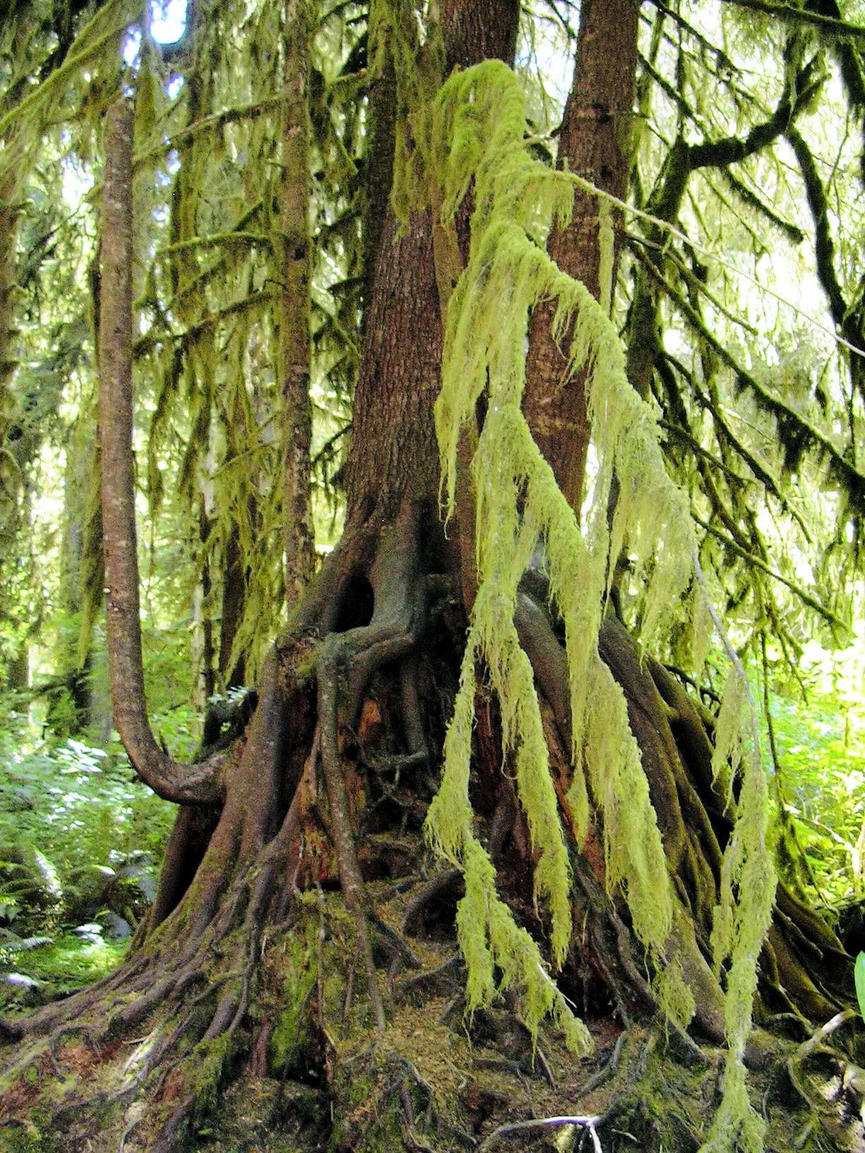
Enchanted Valley hike highlights

  1. 13 miles one way by the park's trail page, 14 by Recreation.gov; about 1,700 feet of elevation change
  2. Camps at Pony Bridge (2.5 miles), O'Neil Creek (7) and Pyrites Creek (10) before the valley
  3. A washed-out section about a third of a mile before the chalet: ford the river or route-find up a steep hillside
  4. A quota of 208 users or 30 permits per night, whichever is hit first
  5. Bears grazing the meadow in the open; the park's instruction is to stay 50 yards back
  6. Bear canisters required, and loaned free at Wilderness Information Centers
  7. Graves Creek Road is reachable only via North Shore Road, and bars RVs and trailers

How hard the Enchanted Valley hike is

  • Physical DemandFitness and endurance required3/5
  • Technical SkillClimbing, scrambling, or specialized skills2/5
  • Exposure RiskSteep dropoffs and fall potential3/5
  • NavigationRoute finding and trail clarity2/5
  • CommitmentDifficulty of bailing out mid-route3/5

Best for: Backpackers comfortable with river fords and mud. The mileage is long but the grade is gentle: 1,700 feet spread over 13 miles.

Recommended experience: Prior multi-day backpacking, and specifically prior experience crossing moving water. The exposure rating here is about the washout traverse and the fords, not about heights.

Not recommended for: Anyone who has not forded a river before, and anyone travelling after heavy rain. The washout before the chalet and the White Creek crossing are both judgement calls with real consequences.

Trailhead information

Graves Creek Ranger Station

Primary

Start of the East Fork Quinault River Trail, and mile zero for every Recreation.gov camp name on this permit.

  • No restrooms
  • No water

Getting There

Reach Graves Creek Road via North Shore Road. RVs and trailers are prohibited on Graves Creek Road. Check the NPS Olympic conditions page before you drive: South Shore Road has been washed out and access from that side comes and goes.

Nearest Services

Quinault Rain Forest Ranger Station, 913 North Shore Road, Amanda Park, WA 98526. It is seasonal, open Memorial Day weekend through the end of September, Thursday through Monday. NPS says bear canisters are loaned there, and the canister return bin is available year round.

When to hike Enchanted Valley

Best time to visit

The park gives a best season of May through September, and the reservation season runs May 15 to October 15. Late June through August has the highest water in the falls with the most reliable fords; September is quiet and clear but the waterfalls thin out. Whenever you go, check the park's wilderness trail conditions page for the washout before the chalet.

Peak
Late June through August
Shoulder
May and September
  • Spring

    High water and the most waterfalls of the year. Fords are at their most serious and the reservation season does not open until May 15.

    Crowd level · low

    • Advantage: The valley walls run with water at their fullest
    • Advantage: Very few other parties
    • Advantage: Bears are active and visible in the meadow
    • Challenge: The most dangerous fords of the year at White Creek and the washout
    • Challenge: Persistent rain
    • Challenge: No permits before May 15
  • Summer

    The park's best-season window. Lower water, drier trail, and the fords at their most manageable.

    Crowd level · high

    • Advantage: Most reliable river crossings
    • Advantage: Warm enough to enjoy the meadow
    • Advantage: Long daylight for a 13-mile day
    • Challenge: The quota binds hardest now: 208 users or 30 permits a night
    • Challenge: Waterfalls thin out as the snow above runs down
    • Challenge: Bugs in the meadow
  • Fall

    Quiet and clear early on, then the rain returns. The reservation season ends October 15.

    Crowd level · moderate

    • Advantage: Easiest permits of the season
    • Advantage: Maples turning along the river
    • Advantage: Cool walking temperatures
    • Challenge: Rivers rise again with the autumn rain
    • Challenge: Short daylight for the 13-mile approach
    • Challenge: Season ends October 15
  • Winter

    Outside the reservation season. Wet, dark and prone to flooding on the East Fork Quinault.

    Crowd level · low

    • Advantage: Nobody else is out there
    • Challenge: The reservation season runs May 15 to October 15 only
    • Challenge: Flood-prone fords with no margin
    • Challenge: Road washouts on the Quinault approach

Weather Forecast

Trailhead (5,000 ft)

⚠️

Backcountry Tips

  • Today: Wind gusts to 42mph. Secure tent, avoid exposed ridges.
  • Today: 100% chance of precipitation. Pack rain gear.

Today

🌧️

49°

39°

100%

Wed

☁️

46°

36°

Thu

🌧️

47°

40°

Fri

🌧️

52°

41°

Sat

⛅

62°

38°

Sun

☁️

66°

45°

Mon

☁️

59°

42°

View full NWS forecast →Mountain weather changes rapidly. This forecast is a guide—always be prepared for worse conditions.

Enchanted Valley photography guide

Golden Hour

Late afternoon light coming over the ridge onto the chalet with the waterfall wall behind it.

Best Light

Overcast is the rainforest's best light. The moss and the falls both photograph better without hard sun. Save direct light for the meadow.

Beat the Crowds

Pony Bridge is the day-hike turnaround, so everything past mile 3 thins out fast. The valley itself is emptiest before 9 am, when most parties are still walking up.

Classic Shots

  1. The chalet with the waterfall wall of Chimney Peak behind it
  2. Pony Bridge over the East Fork Quinault gorge
  3. Bears grazing the meadow, shot long from 50 yards back
  4. Moss and bigleaf maple along the lower river trail
  5. The valley floor in early morning fog

Enchanted Valley rules, gear and safety

Gear checklist

Required
  • An approved bear canister, required here and free to borrow at a Wilderness Information Center
  • Shoes or sandals you can ford in, for the washout and for White Creek
  • Rain gear that actually works; this is a temperate rainforest at any time of year
  • Water treatment

Recommended gear

  • Trekking poles for the fords
  • Gaiters, because the trail holds mud well into summer
  • A dry bag for everything you need dry
  • Insect repellent for the meadow in early summer

Rules & regulations

  1. 01A wilderness permit is required for every overnight trip and must be reserved on Recreation.gov
  2. 02Group size is limited to 12 people and 8 stock; affiliated groups may not combine and must camp and travel at least 1 mile apart
  3. 03Parties of 7 to 12 must use designated group sites; the park names the Sol Duc/Seven Lakes Basin, Hoh Lake Trail, Hoh River Trail, Grand Valley, Upper Lena Lake and Lake Constance areas specifically
  4. 04Bear canisters are required; hanging food, garbage or scented items in bags is prohibited in this area
  5. 05Stay at least 50 yards from the bears in the valley
  6. 06Permits are issued around 3 days before your trip start date
  7. 07No sites are held as same-day walk-ups, and there is no paper self-registration at trailheads

Hazards & considerations

  • The washout about a third of a mile before the chalet: the park says be prepared to ford the river or route-find up a steep hillside
  • White Creek below the O'Neil Pass junction must be forded and can be swift or deep in heavy rain or snowmelt
  • A large bear population in the valley, at close range and in the open
  • Rain and river rise; the East Fork Quinault comes up fast
  • The Quinault South Shore Road washout adds a detour and rules out RVs and trailers

Safety & planning

Emergency Info

Emergency contacts, ranger station locations, and satellite communicator tips for Enchanted Valley.

Food Storage

Bear canister requirements, approved container lists, and rental locations for this permit.

Gear Checklist: Required and recommended gear for Enchanted Valley · Shuttle Services: Trailhead transportation options · Guide Services: Experienced wilderness guides

Some links may be affiliate links. Purchases support PermitSnag at no extra cost to you.

Enchanted Valley FAQ

Do I need a permit to backpack to Enchanted Valley?

Yes. Every overnight trip in Olympic National Park wilderness needs a permit reserved on Recreation.gov. It costs $6 per permit plus $8 per person per night for anyone 16 or older, and the park holds no same-day walk-up sites.

How many people are allowed in Enchanted Valley per night?

The park caps the East Fork Quinault River Trail and Enchanted Valley at a maximum of 208 users or 30 permits per night, whichever is reached first. This started in 2024 as a trial that will last up to three years, so it may change or become permanent.

How far is the hike to Enchanted Valley?

13 miles one way from Graves Creek by the park's own trail page, with about 1,700 feet of elevation change. Recreation.gov's site listing says 14 miles. The park rates the trail moderate.

Do I need a bear canister for the Enchanted Valley permit?

Yes. Enchanted Valley is one of the areas Olympic names specifically, and hanging food, garbage or scented items in bags is prohibited there. Canisters can be borrowed free at Wilderness Information Centers when you pick up your permit. The park also says the valley has a large population of bears and to stay a minimum of 50 yards away.

Is the trail to Enchanted Valley washed out?

Part of it. As of the park's 2026-07-27 wilderness trail conditions update, a section about a third of a mile before the chalet and campsites has washed out, and hikers should be prepared either to ford the river or to route-find up a steep hillside. Separately, White Creek below the O'Neil Pass junction has to be forded and can run swift or deep after rain or snowmelt.

How do I drive to the Graves Creek Trailhead for Enchanted Valley?

Via the Quinault North Shore Road. The South Shore Road has been under a partial closure since 2025-11-13 for a washout in Jefferson County about 8 miles from US 101. Graves Creek Road itself was listed open as of 2026-05-28, but it prohibits RVs and trailers.

When do reservations open for an Enchanted Valley permit?

April 15 at 7:00 am Pacific, for the whole summer season from May 15 through October 15. There is no lottery. Because nothing is held back for walk-ups, that release is effectively the whole supply.

Alternatives to an Enchanted Valley permit

  • Similar ExperiencePermit required

    Hoh River Trail

    The park's other big rainforest river walk, 17.4 miles up to Glacier Meadows below the Blue Glacier.

    Tradeoffs

    Longer, and its quota covers only the upper camps, so the lower river is easier to book. The upper end has its own hazards, including a rope ladder in an avalanche chute the park reported with broken rungs.

  • Same AreaPermit required

    Seven Lakes Basin and High Divide

    The 18.2-mile alpine loop out of Sol Duc, with lakes, meadows and a ridge walk facing Mount Olympus.

    Tradeoffs

    High country rather than rainforest, and 3,050 feet of climbing. Its season is shorter: snow on High Divide often lasts into mid-July.

  • Same AreaPermit required

    Olympic Wilderness Permit

    The park-wide overnight wilderness permit covering every non-quota area in Olympic.

    Tradeoffs

    Far more choice and much less competition, but the quota areas, which is where most of the famous scenery is, still have to be booked as quota areas.

Where to stay near Enchanted Valley

Plan the full trip, not just the permit

Build your full itinerary start to finish

Add your dates and get a day-by-day plan: what needs a permit, what gear to bring, and one link to share with your whole group to coordinate every step.

Plan a trip here

No permit needed to start

One tick helps us more than you’d think

Google lets you pick the sites it highlights for you. Add PermitSnag and our permit pages get marked as one of yours in AI Overviews and AI Mode.

Add PermitSnag in Google

Takes less than a minute.