Skip to content
Ozette Triangle Permit permit area in Olympic National Park - backcountry hiking destination
Booked one camp per night, in order

Ozette Triangle Permit

Olympic National Park · Washington

Coastal wilderness camping.

Get an alert when a night opens on your Ozette Coast dates.

Get alerts for your Ozette Coast nights

An Ozette Coast reservation is a sequence of nights, and each night books a camp.

Give us your trip window and we check every night of it across all camps on this permit, then tell you the moment nights open.

Cover the whole trip, plus any spare days you could shift onto. A wider window catches more openings.

The window above is how much time you have to work with. This is how many nights the trip itself takes. Leave it blank and we'll check every night in the window. We alert you when 2 or more nights in a row open.

Party

70% of the openings our scanner caught on Ozette Coast were gone within 10 minutes.

Ozette Coast reservation dates

Application window
Opens Not a lottery: summer reservations are released April 15 at 7:00 am Pacific
Season
Year-round; the park rates April through October as the best season to Year-round
route distance, loop
9.2mi
max group size
12people

Where to camp on the Ozette Triangle

The loop is 9.2 miles from Ozette Ranger Station Trailhead. There are 3 places to camp on the loop.

9.2 mi loop

Cape Alava

Camp
Mile 3.3 of 9.2

Elevation 11 ft

The westernmost point in the contiguous United States and the north camp. Ozette Island sits offshore.

Ozette Triangle, stop by stop from Ozette Ranger Station Trailhead

How to get an Ozette Coast permit

As of September 2026, Ozette Coast in Olympic National Park, Washington requires a permit issued via reservation. Ozette Coast is a high-demand permit, rating 7/10 on PermitSnag's demand index. Cancelled Ozette Coast permits are re-released on the booking system, and PermitSnag alerts you the moment one opens. The Ozette Coast route covers 9.2 miles, rated easy.

Type
Overnight
Location
Olympic Coast, WA
  1. Step 1: Create a National Park Service account

    Sign up at National Park Service if you don't have an account. Have your payment info ready.

  2. Step 2: Know the release schedule

    Permits release on a rolling basis. Check the release time for your dates.

  3. Step 3: Be ready when permits drop

    Log in a few minutes early. Have your dates, group size, and payment ready to go.

  4. Step 4: Monitor for cancellations

    If your dates are sold out, people cancel all the time. Set up PermitSnag alerts to catch openings instantly.

Ozette Coast pro tips

  1. Plan the beach leg around low tide, not around when you feel like walking. The park says the safest time to round a headland is within one to two hours before low tide.
  2. Carry leather gloves. Several headland trails have fixed ropes and cable ladders, and wet manila is unpleasant without them.
  3. In August, carry your water. The park says the Wedding Rocks, Sand Point and South Sand Point sources typically dry up later in the summer.
  4. Check WSDOT for SR 112 before you drive. The Ozette Road itself is paved and was open as of 2025-11-13, but the highway to it closes regularly for flooding and landslides.
  5. Walk the beach leg north to south. The petroglyphs at Wedding Rocks are easier to spot with the low sun behind you in the afternoon.

More on Ozette Coast: Live availability activityWhen Ozette Coast permits open upDo I need a Ozette Triangle permit?

How much an Ozette Coast permit costs

Ozette Coast permit fee: $6 non-refundable reservation fee per permit, plus $8 per person per night for adults 16 and over. Under 16 camp free.

The Ozette Coast hike

Distance
9.2 miles
Route Type
Loop
Duration
2 days
Difficulty
Easy
High Point
100 ft

Three boardwalk miles out to the westernmost point in the contiguous United States, a night on the beach, and three miles of sea stacks and petroglyphs back, all of it timed against the tide, not the clock.

About this permit

The Ozette Triangle is a 9.2-mile loop: boardwalk from the Ozette Ranger Station out to Cape Alava, three miles of open beach south to Sand Point, and boardwalk back. The park rates it easy, gives elevation as sea level to 100 feet, lists no river crossings on the loop, and calls April through October the best season.

Camping needs an Olympic wilderness permit reserved on Recreation.gov: $6 per permit plus $8 per person per night for anyone 16 or over. The park lists the Ozette Coast from Yellow Banks to Point of the Arches as a quota area with permits limited year round. What Recreation.gov shows bookable is the practical limit. Summer-season reservations for May 15 through October 15 are released on April 15 at 7:00 am Pacific and nothing is held for same-day walk-ups.

Two rules matter more here than anywhere else in the park. The first is tides: the park publishes specific tidal restriction points along this coast (a 6-foot restriction 7.9 miles south of the Ozette Ranger Station trailhead, a 5-foot restriction at 4.9 miles, 5-foot and 4-foot restrictions 0.7 miles south of the Ozette River, and 4- to 6-foot restrictions between Point of the Arches and Seafield Creek) and states plainly that certain sections of the route are physically impassable during higher tides. Carry a tide chart; they are available at visitor centers and coastal ranger stations.

The second is food. Bear canisters are required along the entire Olympic wilderness coast, and here the animal that actually gets your food is the raccoon. The park's own wording: raccoons can easily get food bags hung in trees, so always store all food, garbage, and scented items in bear canisters on the coast. Canisters are free to borrow at Wilderness Information Centers.

One more thing for an August trip: the park warns that later into the summer the Wedding Rocks, Sand Point and South Sand Point water sources typically dry up, and that parties should carry in the water they will need while staying at those locations.

The route

The loop is 9.2 miles: boardwalk out to Cape Alava, three miles of beach south past Wedding Rocks to Sand Point, and boardwalk back to Ozette. Elevation runs from sea level to about 100 feet and the park rates it easy, with a best season of April through October and no river crossings on the loop itself.

The beach section is the part that needs planning. The park is direct about it: be prepared to hike over headland trails during high tides, some headlands cannot be rounded during the lowest of tides, and bring a map and a tide chart to plan your route. Headland trails are marked with red and black targets, and cable ladders or fixed ropes may be on site to assist climbing. Leather gloves are worth carrying for the ropes. The safest time to round a headland is within one to two hours before low tide.

Why it matters

The Ozette Triangle is the easiest way into Olympic's wilderness coast, and the only one where the walking in and out is on boardwalk rather than headland scrambles. It is also on Makah and Ozette ancestral ground: the Wedding Rocks petroglyphs sit between the two camps, and the stretch between Cape Alava and the south side of the Ozette River is the Ozette Indian Reservation, where camping is prohibited outright.
The feeling

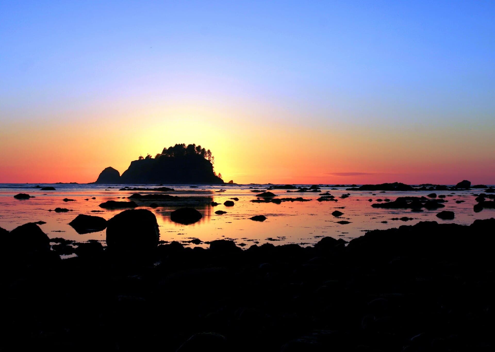
Three miles of cedar planking through bog and forest, and then the trees stop and there is the Pacific with Ozette Island offshore. Camp is on the sand above the tide line, driftwood everywhere, and the surf runs all night. In the morning the tide decides what time you leave.

Ozette Coast hike highlights

  1. 9.2 miles as a loop: 3.3 miles out to Cape Alava, 2.9 miles of beach, 2.8 miles back from Sand Point
  2. Sea level to about 100 feet, with no river crossings on the loop itself
  3. Camps at Cape Alava, Wedding Rocks, Sand Point, South Sand Point and Yellow Banks
  4. Wedding Rocks has no water and no pit toilets
  5. Tide-dependent headlands with red-and-black target markers, cable ladders and fixed ropes
  6. Bear canisters required, and raccoons rather than bears are the animal that takes unsecured food
  7. Camping is prohibited on the Ozette Indian Reservation between Cape Alava and the south side of the Ozette River

How hard the Ozette Coast hike is

  • Physical DemandFitness and endurance required2/5
  • Technical SkillClimbing, scrambling, or specialized skills2/5
  • Exposure RiskSteep dropoffs and fall potential3/5
  • NavigationRoute finding and trail clarity2/5
  • CommitmentDifficulty of bailing out mid-route2/5

Best for: First-time coastal backpackers and families who can read a tide table. Nine miles with 100 feet of elevation is easy walking.

Recommended experience: None beyond basic backpacking, plus the willingness to read a tide chart and set your schedule from it.

Not recommended for: Anyone who will not plan around the tide. The exposure rating here is entirely about being caught by a rising tide at a headland, and about the ladders and ropes you use to escape one, not about the terrain being hard.

Trailhead information

Ozette Ranger Station

Primary

Both legs of the Triangle start here. NPS says the three miles of boardwalk out to Cape Alava or Sand Point can be extremely slick, and that soft-soled shoes grip it better than stiff lug soles.

  • No restrooms
  • No water

Getting There

NPS asks visitors to check with the Washington State Department of Transportation before travelling, because SR 112 has been subject to frequent closure and detours from flooding and landslides.

Notes

Bear canisters are required for any overnight stay in Olympic's wilderness. NPS loans them at two places, the Port Angeles Wilderness Information Center and the Quinault Rain Forest Ranger Station, so pick one up before you drive out to Ozette.

Trailhead information

Swan Bay Boat Launch

Alternate

Paddle access to the Lake Ozette boat-in camps. Recreation.gov puts Erickson's Bay about 4 miles out and warns of high winds, 1-2 foot waves and cold water on the lake.

  • No restrooms
  • No water

Notes

NPS says the boat-in campsites on Lake Ozette are non-quota, so a permit for a lake site is not a reservation for that site. Sites stay first come, first served, and for anything other than Erickson's Bay the Wilderness Information Center books them by phone or email.

When to hike Ozette Coast

Best time to visit

The park calls April through October the best season. July through September gives the driest boardwalk and the calmest surf, but it is also when the coastal water sources dry up, so plan to carry. Spring and autumn bring bigger swell, wetter planking and far fewer people. Permits are limited year round on this stretch of coast.

Peak
July through September
Shoulder
April to June, and October
  • Spring

    Wet boardwalk, big swell, and the water sources still running. The park's best-season window opens in April.

    Crowd level · moderate

    • Advantage: Coastal water sources still flowing
    • Advantage: Grey whale migration offshore
    • Advantage: Far fewer people than midsummer
    • Challenge: Slick boardwalk: the park warns it is extremely slippery when wet or frosted
    • Challenge: Larger swell narrowing the beach at high tide
    • Challenge: Persistent rain
  • Summer

    Driest planking and calmest surf of the year, and the season the coastal water sources fail.

    Crowd level · high

    • Advantage: Best conditions for the beach leg and the headlands
    • Advantage: Long daylight to work around an awkward tide
    • Advantage: Sunsets straight down the Pacific
    • Challenge: Water at Wedding Rocks, Sand Point and South Sand Point typically dries up
    • Challenge: The hardest permits of the year on a year-round quota
    • Challenge: Fog can sit on the coast for days
  • Fall

    The park's best season runs to the end of October. Rain returns, swell builds, and the sources refill.

    Crowd level · moderate

    • Advantage: Water flowing again at the beach camps
    • Advantage: Storm-watching from a safe camp above the tide line
    • Advantage: Permits ease off
    • Challenge: Bigger surf compressing the passable window at headlands
    • Challenge: Slippery boardwalk again
    • Challenge: Short daylight against a fixed tide schedule
  • Winter

    Permits are limited year round and the loop stays open, but it is a storm coast in winter.

    Crowd level · low

    • Advantage: Complete solitude
    • Advantage: The biggest surf of the year
    • Challenge: Storm surge and driftwood movement on the beach
    • Challenge: SR 112 closes regularly for flooding and landslides
    • Challenge: Frosted boardwalk, which the park singles out as extremely slippery

Weather Forecast

Trailhead (5,000 ft)

⚠️

Backcountry Tips

  • Today: Wind gusts to 42mph. Secure tent, avoid exposed ridges.
  • Today: 100% chance of precipitation. Pack rain gear.

Today

🌧️

49°

39°

100%

Wed

☁️

46°

36°

Thu

🌧️

47°

40°

Fri

🌧️

52°

41°

Sat

⛅

62°

38°

Sun

☁️

66°

45°

Mon

☁️

59°

42°

View full NWS forecast →Mountain weather changes rapidly. This forecast is a guide—always be prepared for worse conditions.

Ozette Coast photography guide

Golden Hour

Sunset from Cape Alava with Ozette Island offshore. You are at the westernmost point in the contiguous US, so the sun goes down over open water.

Best Light

Low afternoon sun raking across the Wedding Rocks petroglyphs brings out the carving that midday flattens out.

Beat the Crowds

The boardwalk carries day-hikers to Cape Alava and back, and they are gone by late afternoon. Camp at Sand Point rather than Cape Alava if you want the quieter end.

Classic Shots

  1. Sea stacks off Cape Alava at sunset
  2. The cedar boardwalk running out through the bog
  3. Wedding Rocks petroglyphs in low side light
  4. Driftwood and surf from camp above the tide line
  5. Tide pools at Sand Point on a minus tide

Ozette Coast rules, gear and safety

Gear checklist

Required
  • An approved bear canister, required on the entire coast and free to borrow at a Wilderness Information Center
  • A current tide chart, available at visitor centers and coastal ranger stations
  • A stove; open fires are prohibited through the Sand Point and Wedding Rocks stretch
  • Rain gear, and dry bags for anything that must stay dry
  • Water treatment, plus the capacity to carry water in late summer when the coastal sources dry up

Recommended gear

  • Leather gloves for the fixed ropes on the headland trails
  • Footwear you do not mind soaking on wet, slick boardwalk and cobble
  • Trekking poles for the beach cobble sections
  • A watch you can read at 5 am, because the tide sets your start time

Rules & regulations

  1. 01A wilderness permit is required for every overnight trip and must be reserved on Recreation.gov
  2. 02Groups are limited to 12 people; associated groups must camp and travel at least 1 mile apart, may not combine, and must camp in separate camp areas such as Cape Alava and Sand Point
  3. 03All food, garbage and scented items must be stored in a park-approved bear canister along the entire Olympic wilderness coast
  4. 04Open fires are prohibited between the headland north of Yellow Banks and the headland at Wedding Rocks, including the Sand Point area
  5. 05Camp above the high tide water line when camping on the beach
  6. 06Camping is prohibited on the Ozette Indian Reservation, between the Cape Alava and South Side of Ozette River campsites
  7. 07Cannonball Island (Tskawahyah Island) is part of the Ozette Indian Reservation and is always closed to the public
  8. 08Permits are issued around 3 days before your trip start date

Hazards & considerations

  • Tides. The park publishes specific restriction heights along this coast and says certain sections are physically impassable during higher tides
  • Slippery boardwalk: the park reported some weak planks with a few loose or broken ones on 2026-06-15, and notes the boardwalk can be extremely slippery if wet or frosted
  • Headland trails with cable ladders and fixed ropes, taken when the beach route is closed by tide
  • Raccoons raiding camps; the park says they climb trees to reach hung food bags
  • Dry water sources at Wedding Rocks, Sand Point and South Sand Point later in the summer
  • SR 112, the approach highway, has been subject to frequent closure and detours from flooding and landslides

Safety & planning

Emergency Info

Emergency contacts, ranger station locations, and satellite communicator tips for Ozette Coast.

Food Storage

Bear canister requirements, approved container lists, and rental locations for this permit.

Gear Checklist: Required and recommended gear for Ozette Coast · Shuttle Services: Trailhead transportation options · Guide Services: Experienced wilderness guides

Some links may be affiliate links. Purchases support PermitSnag at no extra cost to you.

Ozette Coast FAQ

Do I need a permit to camp on the Ozette Triangle?

Yes, for any overnight. Olympic National Park wilderness permits are reserved on Recreation.gov at $6 per permit plus $8 per person per night for anyone 16 or over. The park lists the Ozette Coast from Yellow Banks to Point of the Arches as a quota area with permits limited year round. Day hiking the loop needs no permit.

How long is the Ozette Triangle loop?

9.2 miles, by the park's own trail page: 3.3 miles out to Cape Alava, a 2.9-mile beach walk, and 2.8 miles back from Sand Point, by the park's day-hiking page (which adds them to 9.0). Elevation runs from sea level to about 100 feet and the park rates it easy.

Do I need a tide chart for the Ozette Triangle?

Yes. The park says to bring a map and a tide chart to plan your route, and states that certain sections of this route are physically impassable during higher tides. It publishes specific restriction heights, including a 5-foot restriction 4.9 miles south of the Ozette trailhead and a 6-foot restriction at 7.9 miles. Charts are available at visitor centers and coastal ranger stations.

Is there drinking water at the Ozette Triangle campsites?

Not reliably in late summer. The park warns that later into the summer the Wedding Rocks, Sand Point and South Sand Point water sources typically dry up, and that parties should carry in the water they need while staying there. Wedding Rocks has no pit toilets either. Treat whatever you find.

Do I need a bear canister on the Olympic coast?

Yes. All food, garbage and scented items must be stored in a park-approved bear canister along the entire Olympic National Park wilderness coast. The park is explicit that this is partly about raccoons, which climb trees and can easily get food bags hung there. Canisters are free to borrow at Wilderness Information Centers.

Can I have a campfire at Sand Point or Cape Alava?

Not at Sand Point. Open fires are prohibited between the headland north of Yellow Banks and the headland at Wedding Rocks, including the Sand Point area. Bring a stove.

Can I camp anywhere along the beach on the Ozette Triangle?

No. Camping is prohibited on the Ozette Indian Reservation, which is the stretch between the Cape Alava and South Side of Ozette River campsites, and Cannonball Island is always closed to the public. Where you can camp on sand, the park requires you to camp above the high tide water line.

Ozette Coast trail conditions and trip reports

Trail Conditions

No active conditions reported

Sign in to report trail conditions.

Questions

No questions yet

Be the first to ask about Ozette Coast.

Trip Reports

Write Report

No trip reports yet

Be the first to share your experience at Ozette Coast.

Write the First Report

Alternatives to an Ozette Coast permit

  • Similar ExperiencePermit required

    Olympic Coast Trail

    The longer wilderness coast routes, north and south, on the same permit system and the same tide rules.

    Tradeoffs

    Much more committing: more headlands, more rope ladders and more sections that cannot be rounded at any tide. The Ozette Triangle is the introduction to it.

  • Same AreaPermit required

    Enchanted Valley

    13 miles up the East Fork Quinault to a waterfall-ringed meadow and the 1930s chalet.

    Tradeoffs

    Inland rainforest instead of coast, and no tide to plan around, but river fords instead, plus a washout a third of a mile before the chalet.

  • Same AreaPermit required

    Olympic Wilderness Permit

    The park-wide overnight wilderness permit for Olympic's non-quota areas.

    Tradeoffs

    Easier to book, but the coast from Yellow Banks to Point of the Arches is limited year round and has to be booked as the quota area it is.

Where to stay near Ozette Coast

Plan the full trip, not just the permit

Build your full itinerary start to finish

Add your dates and get a day-by-day plan: what needs a permit, what gear to bring, and one link to share with your whole group to coordinate every step.

Plan a trip here

No permit needed to start

One tick helps us more than you’d think

Google lets you pick the sites it highlights for you. Add PermitSnag and our permit pages get marked as one of yours in AI Overviews and AI Mode.

Add PermitSnag in Google

Takes less than a minute.