Skip to content
Inyo NF Wilderness Permit — Kearsarge Pass (JMT) permit area in Inyo National Forest - backcountry hiking destination
Each entry point carries its own quota

Inyo NF Wilderness Permit — Kearsarge Pass (JMT)

Inyo National Forest · California

Wilderness permit for entry via Kearsarge Pass (JMT) in Inyo National Forest. Access to John Muir Wilderness and Ansel Adams Wilderness.

Get an alert when Kearsarge Pass (JMT) opens on your dates.

Get alerts for your Kearsarge Pass (JMT) dates

A Kearsarge Pass (JMT) permit is booked by the day you start. Tell us every date you'd go and we'll ping you the second one of them opens up.

Leave the second date blank if only one day works. A wider window catches more openings.

Party

When it opens

6 months
First come, first served from six months before your entry date, at 7 am Pacific60% of quotaYou book on Recreation.gov.
2 weeks
First come, first served from two weeks before your entry date, at 7 am Pacific40% of quotaYou book on Recreation.gov.

Source: recreation.gov

70% of the openings our scanner caught on Kearsarge Pass (JMT) were gone within 10 minutes.

Kearsarge Pass (JMT) reservation dates

Season
May 1 to November 1
route distance, varies by route
15.2mi
elevation gain
2,500ft
max group size
15people

How to get a Kearsarge Pass (JMT) permit

As of September 2026, Kearsarge Pass (JMT) in Inyo National Forest, California requires a permit issued via reservation. Kearsarge Pass (JMT) is one of the most competitive permits in the United States, rating 9/10 on PermitSnag's demand index. Cancelled Kearsarge Pass (JMT) permits are re-released on the booking system, and PermitSnag alerts you the moment one opens. The permit season for Kearsarge Pass (JMT) runs May 1 through November 1. The Kearsarge Pass (JMT) route covers 15.2 miles with 2,500 feet of elevation gain, rated strenuous.

Type
Overnight
Location
John Muir Wilderness, Eastern Sierra, CA
  1. Step 1: Create an account before permits drop

    Find this permit on the managing agency's booking system and set up an account with your payment info ready.

  2. Step 2: Know the release schedule

    Permits release on a rolling basis. Check the release time for your dates.

  3. Step 3: Be ready when permits drop

    Log in a few minutes early. Have your dates, group size, and payment ready to go.

  4. Step 4: Monitor for cancellations

    If your dates are sold out, people cancel all the time. Set up PermitSnag alerts to catch openings instantly.

Kearsarge Pass (JMT) pro tips

  1. Six months out at 7 am Pacific is the real release moment: mark the date your entry date minus six months
  2. If you see "NR", set a second alarm for two weeks before entry on the same weekday as your entry date
  3. Name "Mt Whitney (Trail Crest Exit)" at reservation time if you plan to finish at Whitney Portal; it cannot be improvised later
  4. Print the permit before 10 am on your entry date or it is cancelled as a no-show
  5. Sleep at Onion Valley the night before: 9,100 feet at the trailhead is already altitude
  6. Cancel at least 12 full days out if plans change and the per-person fee comes back automatically

More on Kearsarge Pass (JMT): Live availability activityWhen Kearsarge Pass (JMT) permits open upChance of an opening

How much a Kearsarge Pass (JMT) permit costs

Kearsarge Pass (JMT) permit fee: $6 per reservation + $5 per person.

The Kearsarge Pass (JMT) hike

Distance
15.2 miles
Elevation Gain
2,500 ft
Route Type
Varies
Duration
3-6 days
Difficulty
Strenuous
Elevation Range
9,200 - 11,700 ft

Kearsarge Pass (JMT) elevation profile

Onion Valley Trailhead to John Muir Trail junction near Bullfrog Lake

1,193 ft of descent · 7.3% average grade

Landmark 1 of 6Trailhead

Onion Valley Trailhead

Road end 13 miles west of Independence. Bear container use is required throughout the Kearsarge Pass area.

Mile
0.0
Elevation
9,200 ft
From start
+0 ft
  1. Road end 13 miles west of Independence. Bear container use is required throughout the Kearsarge Pass area.

  2. First of the lakes on the climb, in forest below the tundra line.

  3. The second lake on the climb, named in Inyo National Forest's own trail description.

  4. Last of the named lakes before the trail breaks out into alpine tundra.

  5. The crest and the boundary with Kings Canyon National Park. Campfires are prohibited in the Kearsarge Pass and Onion Valley area.

  6. Where the trail meets the JMT. No camping within a quarter mile of Bullfrog Lake, and a two-night limit at Kearsarge and Charlotte Lakes.

Six and a half miles from a road-end at 9,100 feet to the John Muir Trail, the shortest legal walk onto the JMT from anywhere in the Eastern Sierra.

About this permit

Kearsarge Pass is an Inyo National Forest wilderness permit for the Onion Valley trailhead, 13 miles west of Independence. The trail climbs 2,600 feet from 9,100 feet at the road to 11,700 feet at the pass, then drops into Kings Canyon National Park and meets the John Muir Trail near Bullfrog Lake, 6.5 miles from the car.

Inyo runs a different reservation system from Yosemite's. There is no lottery: 60% of each trail's quota is released six months in advance at 7 am Pacific, and the remaining 40% two weeks in advance on the same day of the week. A listing showing "NR" means the first 60% is gone and the second tranche has not dropped yet.

Quota season runs May 1 to November 1. Outside it, permits are unlimited and bookable up to two weeks ahead.

The route

Inyo National Forest describes the route in one sentence worth reading twice: "The Kearsarge Pass trail begins at an elevation of 9,100 ft. at Onion Valley and climbs through forests and alpine tundra past several lakes including Big and Little Pothole, Gilbert, and Flower Lakes on the way to Kearsarge Pass at 11,700 ft." That is 2,600 feet of climbing on the east side, most of it in the open.

From the pass the trail crosses into Kings Canyon National Park and drops toward the Kearsarge Lakes basin, joining the John Muir Trail near Bullfrog Lake 6.5 miles from the car. Sequoia and Kings Canyon rules take over at the boundary and they are stricter than the forest's: no camping within a quarter mile of Bullfrog Lake, and a two-night limit at Charlotte and Kearsarge Lakes and along the JMT from Woods Creek Crossing to Vidette Meadow.

From the junction most people go one of two ways. North on the JMT takes you into the Rae Lakes country and the Rae Lakes Loop. South takes you toward Forester Pass, Crabtree and eventually Whitney. If you plan to finish at Whitney Portal, Inyo requires the permit to name "Mt Whitney (Trail Crest Exit)" as the exit point, because Whitney Portal carries a separate exit quota.

Why it matters

Every JMT hiker who fails the Yosemite lottery ends up looking at this trailhead. Inyo National Forest's own description puts it plainly: the trail joins the John Muir Trail near Bullfrog Lake and is "a popular choice for going to the Rae Lakes area and this section of the John Muir Trail." It is also the standard resupply exit for southbound JMT hikers, who drop over the pass to Independence and climb back the next day.

The feeling

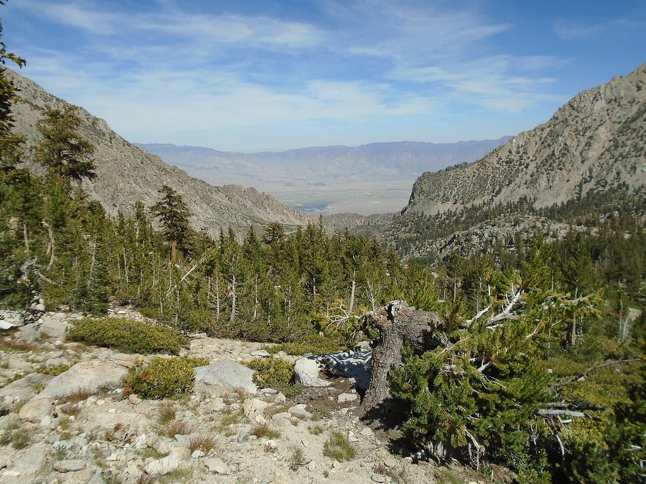
The road ends abruptly in a bowl at Onion Valley and the trail goes straight up the wall of it. You pass Little Pothole, then Gilbert, then Flower Lakes, each one a little smaller and colder than the last, and the trees give out somewhere around the third. At the pass the whole thing flips: the Owens Valley drops away behind you and Kings Canyon opens west in a wall of granite.
Kearsarge Pass (JMT) hike highlights

  1. 6.5 miles from the trailhead to the John Muir Trail junction, per Inyo National Forest
  2. 2,600 feet of climbing on the east side, from 9,100 feet to an 11,700-foot pass
  3. A staircase of lakes (Little Pothole, Gilbert, Flower), then open alpine tundra
  4. A rule change at the crest: Sequoia and Kings Canyon camping restrictions replace forest ones
  5. Heavy use, because this is the standard JMT access and resupply route from the east
  6. A separate exit quota if you plan to finish at Whitney Portal

How hard the Kearsarge Pass (JMT) hike is

  • Physical DemandFitness and endurance required4/5
  • Technical SkillClimbing, scrambling, or specialized skills1/5
  • Exposure RiskSteep dropoffs and fall potential2/5
  • NavigationRoute finding and trail clarity1/5
  • CommitmentDifficulty of bailing out mid-route3/5

Best for: Backpackers heading for the Rae Lakes country or the southern John Muir Trail, and JMT hikers who want a realistic permit instead of a Yosemite lottery ticket.

Recommended experience: Comfortable carrying a pack over an alpine pass and camping above 10,000 feet. No technical skills required when the pass is snow-free.

Not recommended for: Anyone arriving from sea level that morning. The trailhead starts at 9,100 feet and the pass is at 11,700 with no acclimatization built in.

Trailhead information

Onion Valley Trailhead

Primary

9,100 ft elevation

Road end at 9,100 feet, 13 miles west of Independence, at the top of Onion Valley Road.

  • No restrooms
  • No water

Parking

Onion Valley Campground sits at the road end and has no water. Bears work the area. Keep all food out of sight in approved containers and never leave food in a car.

Getting There

Take U.S. Highway 395 to Independence, turn west on Market Street, which becomes Onion Valley Road, and follow it 13 miles.

Nearest Services

Independence, 13 miles east on Onion Valley Road. Permits print at home up to a week ahead; the White Mountain Public Lands Information Center in Bishop and the Eastern Sierra Interagency Visitor Center south of Lone Pine handle in-person help, bear can rentals and maps.

When to hike Kearsarge Pass (JMT)

Best time to visit

Inyo's quota season runs May 1 through November 1, and that is roughly the usable window too. July through September is the reliable stretch: the pass is clear, the lakes are open, and the JMT traffic is at its peak. Outside quota season there is no limit on the number of permits and you can book up to two weeks ahead, but the pass carries snow and the road can be shut.

Peak
July-September
Shoulder
June and October
  • Spring

    Quota season opens May 1, but the pass holds snow and Onion Valley Road may still be closed.

    Crowd level · low

    • Advantage: Quota rarely binding this early
    • Advantage: Full creeks and waterfalls on the climb
    • Challenge: Snow on the pass and postholing above the lakes
    • Challenge: Road access uncertain
    • Challenge: Cold nights at 9,000 feet and up
  • Summer

    The main season. Pass clear, lakes open, and the JMT resupply traffic at full volume.

    Crowd level · high

    • Advantage: Reliable conditions on the pass
    • Advantage: The full John Muir Trail corridor open
    • Advantage: Long days for the 2,600-foot climb
    • Challenge: Afternoon thunderstorms on exposed tundra
    • Challenge: Competition for the 60% released six months out
    • Challenge: Bears working the trailhead and lakes
  • Fall

    The best air and the emptiest trail, until the quota season ends November 1.

    Crowd level · moderate

    • Advantage: Stable weather and clear views west into Kings Canyon
    • Advantage: No mosquitoes
    • Advantage: Quota rarely binding after mid-September
    • Challenge: Hard freezes at the lakes
    • Challenge: Early storms can close the pass
    • Challenge: Short days for a long climb
  • Winter

    Outside quota season, from November 2 through April 30, there is no limit on permits and you can book up to two weeks in advance, but Onion Valley Road and the pass are winter terrain.

    Crowd level · low

    • Advantage: No quota and no competition
    • Advantage: Book as late as two weeks out
    • Challenge: Road closure at Onion Valley
    • Challenge: Full winter conditions on an 11,700-foot pass
    • Challenge: A permit is still required year-round

Weather Forecast

Trailhead (5,000 ft)

Today

☁️

73°

55°

Tue

☀️

81°

50°

Wed

☀️

87°

56°

Thu

☀️

90°

62°

Fri

☁️

90°

64°

Sat

☁️

89°

67°

Sun

⛅

88°

66°

View full NWS forecast →Mountain weather changes rapidly. This forecast is a guide—always be prepared for worse conditions.

Kearsarge Pass (JMT) photography guide

Golden Hour

First light at the pass. The east side climbs into the sunrise, so an early start puts you at 11,700 feet with the Owens Valley still in shadow behind you and the Kings Canyon peaks lighting up west.

Best Light

Late afternoon at Flower Lake, where the last of the trees frame the basin and the granite above goes warm.

Beat the Crowds

This is a resupply corridor, so the traffic pulses: JMT hikers come down in the morning and go back up in the afternoon. Start at dawn and you have the switchbacks to yourself; camp west of the pass and the basin empties out by evening.

Classic Shots

  1. The lake staircase (Little Pothole, Gilbert and Flower) stacked below you from the switchbacks
  2. The Owens Valley 6,000 feet down from the pass
  3. The Kearsarge Pinnacles from the west side of the pass
  4. Kearsarge Lakes basin with the Pinnacles behind, from the descent
  5. The John Muir Trail junction sign near Bullfrog Lake

Kearsarge Pass (JMT) rules, gear and safety

Gear checklist

Required
  • A bear-resistant container, which is required in the Kearsarge Pass area
  • A stove, since campfires are prohibited throughout this area
  • Water treatment
  • Layers for an 11,700-foot pass, where afternoon weather turns fast
  • Sun protection for a mostly shadeless 2,600-foot climb

Recommended gear

  • A California Campfire Permit, which Inyo requires to operate a stove
  • Trekking poles for the switchbacked climb and the descent back over the pass
  • Downloaded maps: Inyo warns most of the forest has no cell service
  • Printed permit, since printing is what stops the 10 am no-show cancellation
  • Bags for packing out toilet paper

Rules & regulations

  1. 01Wilderness permit required year-round for overnight trips in the John Muir Wilderness
  2. 02Maximum group size is 15 people; groups cannot combine to exceed 15
  3. 03Bear-resistant container use is required in the Kearsarge Pass area
  4. 04Camping within 100 feet of lakes, streams or trails is prohibited, and never within 50 feet
  5. 05Campfires are prohibited in the Kearsarge Pass / Onion Valley area, including Golden Trout Lakes and Robinson Lake, and above 10,400 feet south of the Glacier Divide
  6. 06Park rules apply once you cross into Kings Canyon: no camping within a quarter mile of Bullfrog Lake, two-night limits at Charlotte and Kearsarge Lakes and along the JMT from Woods Creek Crossing to Vidette Meadow
  7. 07To finish a trip at Whitney Portal, the permit must specify the exit point "Mt Whitney (Trail Crest Exit)", because Whitney Portal has its own exit quota
  8. 08Print the permit before 10 am on the entry date or the reservation is cancelled as a no-show
  9. 09Bury waste six to eight inches deep and at least 100 feet from water, trails or campsites
  10. 10Wheeled and mechanical devices including drones are prohibited; shortcutting switchbacks is prohibited

Hazards & considerations

  • Altitude: the trailhead is already at 9,100 feet and the pass is at 11,700, with no gradual approach
  • Afternoon thunderstorms on an exposed alpine crossing
  • Snow on the pass early and late in the quota season
  • Bears at the trailhead and through the lakes basin: Inyo requires containers here for a reason
  • Onion Valley Road is a mountain road that climbs 13 miles from Independence and is usually closed by snow in winter
  • No cell service on most of the route

Safety & planning

Emergency Info

Emergency contacts, ranger station locations, and satellite communicator tips for Kearsarge Pass (JMT).

Food Storage

Bear canister requirements, approved container lists, and rental locations for this permit.

Gear Checklist: Required and recommended gear for Kearsarge Pass (JMT) · Shuttle Services: Trailhead transportation options · Guide Services: Experienced wilderness guides

Some links may be affiliate links. Purchases support PermitSnag at no extra cost to you.

Kearsarge Pass (JMT) FAQ

How far is it from Onion Valley to the John Muir Trail over Kearsarge Pass?

6.5 miles, per Inyo National Forest, from the 9,100-foot trailhead over the 11,700-foot pass to the JMT junction near Bullfrog Lake. That is 2,600 feet of climbing to the crest and then a descent on the west side into Kings Canyon National Park.

How do you get a Kearsarge Pass permit?

No lottery. It is a timed release on Recreation.gov. Inyo National Forest puts 60% of each trail's quota online six months in advance at 7 am Pacific, and the remaining 40% two weeks in advance on the same day of the week as your entry date. If the listing says "NR," the first 60% is gone and the second batch has not dropped yet.

What is the daily quota for Kearsarge Pass?

The forest says "each trail has a different daily quota", and quota season runs May 1 to November 1. The live Recreation.gov grid shows the quota for each date.

How much does a Kearsarge Pass permit cost?

A $6 non-refundable reservation fee per permit, plus a $5 per person recreation fee. Inyo charges $15 per person only for trips entering the Whitney Zone. Cancel online at least 12 full days before your entry date and the per-person fee is refunded automatically; the $6 never is.

Do you need a bear canister on the Kearsarge Pass trail?

Yes. Inyo National Forest lists the Kearsarge Pass area among the places where bear container use is required. Bears also work the Onion Valley trailhead and campground hard, so keep food out of your car and in the lockers before you start walking.

Can you have a campfire near Kearsarge Pass?

No. Inyo prohibits campfires in the Kearsarge Pass and Onion Valley area specifically, including Golden Trout Lakes and Robinson Lake, on top of the blanket ban above 10,400 feet south of the Glacier Divide. Bring a stove, and carry a California Campfire Permit, which the forest requires even to run one.

Can you exit at Whitney Portal on a Kearsarge Pass permit?

Only if the permit says so. Inyo is explicit: "For trips ending at Mt Whitney (Whitney Portal) the permit must specify exit point of 'Mt Whitney (Trail Crest Exit)'." Whitney Portal carries its own exit quota, separate from the entry quota you reserved at Kearsarge, so this has to be set at reservation time.

What rules change when you cross into Kings Canyon?

Several, and they are tighter than the forest's. There is no camping within a quarter mile of Bullfrog Lake, a two-night limit at Charlotte and Kearsarge Lakes and along the John Muir Trail from Woods Creek Crossing to Vidette Meadow, and a one-night limit per lake between Dollar Lake and Glen Pass on the Rae Lakes stretch. Your Inyo permit stays valid for continuous travel, but park rules govern once you are inside the boundary.

Alternatives to a Kearsarge Pass (JMT) permit

  • Same AreaPermit required

    Shepherd Pass (JMT)

    The next eastern approach north of Whitney, reaching the JMT and the Kings-Kern Divide country by a longer and much steeper climb.

    Tradeoffs

    Far less competition than Kearsarge and it puts you closer to Whitney, but it is a notoriously punishing approach with a long dry stretch.

  • Similar ExperiencePermit required

    Bishop Pass (JMT)

    An eastern entry from South Lake into Dusy Basin and down to the JMT at LeConte Canyon, on the same Inyo reservation system.

    Tradeoffs

    Reaches a different and more northerly stretch of the JMT. Bear containers are required in the Bishop Pass area too, and Kings Canyon caps Dusy Basin at two nights.

  • Similar ExperiencePermit required

    Rae Lakes Loop

    The loop this trail feeds into, entered instead from Roads End in Kings Canyon on a SEKI permit.

    Tradeoffs

    A different agency and a different quota, and you approach from the west rather than climbing an 11,700-foot pass on day one. SEKI caps camping to one night per lake between Dollar Lake and Glen Pass.

  • Similar ExperiencePermit required

    Happy Isles to Past LYV (Donohue Pass eligible)

    The Yosemite end of the John Muir Trail, if what you actually want is the whole thing northbound to southbound.

    Tradeoffs

    A hard 15-permits-per-day quota through a weekly lottery, against Inyo's release-based system with no lottery at all. One Yosemite permit covers the entire JMT; a Kearsarge permit gets you the southern half.

Where to stay near Kearsarge Pass (JMT)

Plan the full trip, not just the permit

Build your full itinerary start to finish

Add your dates and get a day-by-day plan: what needs a permit, what gear to bring, and one link to share with your whole group to coordinate every step.

Plan a trip here

No permit needed to start

One tick helps us more than you’d think

Google lets you pick the sites it highlights for you. Add PermitSnag and our permit pages get marked as one of yours in AI Overviews and AI Mode.

Add PermitSnag in Google

Takes less than a minute.