Cirque of the Towers Permit
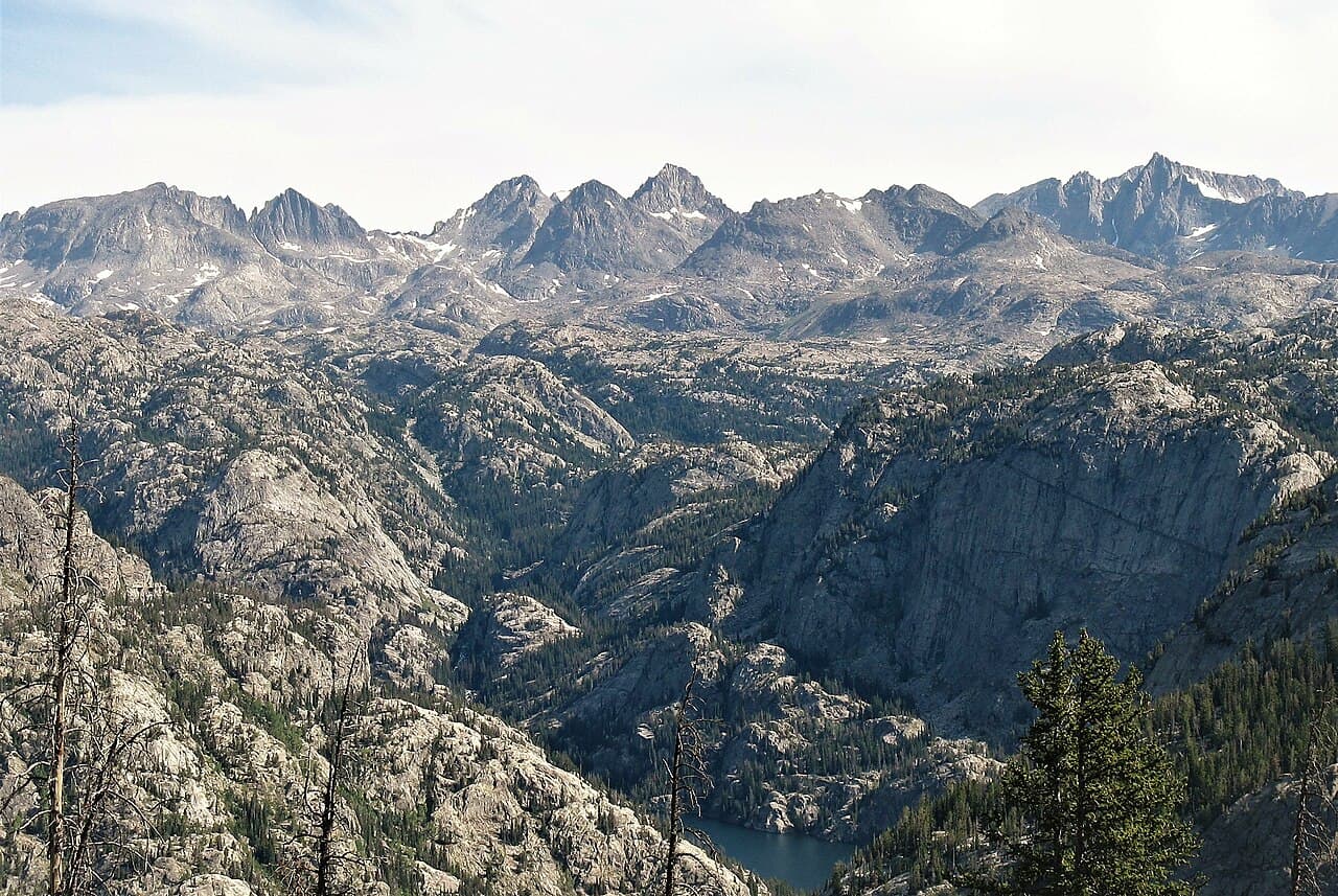
Iconic granite amphitheater. On-trail access from Big Sandy.
“The most famous granite amphitheatre in the Lower 48 has no permit, no quota and no fee. The barrier is that it is 57 miles of road from Pinedale before you start walking.”
Plan your Bridger-Teton National Forest / Wind River Range trip here, then get your permit from the agency.
Walk-up permit
How to get Cirque
Cirque is issued by the agency rather than through a booking calendar. Their page has the current process and any dates.
Official permit pagePlanning another trip? See the permits we alert on.
How to get a Cirque permit
No permit needed.
No permit is required for an individual or family backpacking trip. Bridger-Teton National Forest states that permits are required for group use and overnight stock use in the Bridger Wilderness
Wind Rivers trailheads and parking
- Big Sandy
Wind Rivers trailhead in full
Primary
Big Sandy TrailheadBridger-Teton: one of the more popular trailheads on the Pinedale Ranger District, providing access to the Bridger Wilderness, the Continental Divide Trail and the Cirque of the Towers.
Bridger-Teton lists potable water as not available at this site.
- Restrooms
- No water
- No signal
Parking
Two separate parking areas, one for backpackers and one for equestrians. Both have vault toilets and the stock area has corrals. Open 24 hours a day, no fees.
Getting there
From Pinedale: south on US-191 about 12 miles, left on WY-353 for roughly 15.5 miles where it becomes Big Sandy-Elkhorn Road / CR-118, another 12 miles, left onto Lander Cutoff Road / CR-132 for 7 miles, then left onto Big Sandy Opening Road / FS-370850 for 9.7 miles and right at the fork. Bridger-Teton puts it at 57 miles and about 1 hour 25 minutes.
Nearest services
Pinedale, Wyoming: 57 miles back down the road.
- Permit required
- No
- Type
- Overnight
- Location
- Wind River Range, Wyoming, WY
How this permit is issued
Get this permit in person at the trailhead or ranger station, or by phone.
Official permit page →Cirque pro tips
- No permit is needed for an individual or family trip. Organized groups and anyone bringing overnight stock do need a free permit from the Pinedale Ranger District, applied for from April 1
- Check the Shoshone National Forest alerts for the Cirque of the Towers camping setback from Lonesome Lake before you pick a site
- Fill your water containers before the trailhead. Bridger-Teton lists no potable water at Big Sandy or anywhere in the Bridger Wilderness
- The equestrian lot is a separate parking area off 850B, just before the main lot. Do not follow a horse trailer by mistake
- A separate permit is required to enter the Wind River Indian Reservation, which borders the north side of the Popo Agie Wilderness
More on Cirque: Live availability activity
How much a Cirque permit costs
Cirque permit fee: No fee. Bridger-Teton charges nothing at Big Sandy Trailhead, and individual backpacking needs no permit.
The Cirque hike
- Route Type
- Out & Back
- Duration
- 3-6 days
- Difficulty
- Strenuous
Cirque landmarks
- 1Big Sandy Trailhead
Two parking areas, backpacker and equestrian, both with vault toilets, corrals at the stock lot. Open 24 hours, no fee, and no potable water.
- 2Continental Divide
The boundary between Bridger-Teton and Shoshone National Forest. Regulations change when you cross it, and Bridger-Teton says so explicitly.
- 3Lonesome Lake
The lake inside the Cirque. Shoshone National Forest publishes an additional camping setback here under a special order, with a map posted on its Popo Agie Wilderness page.
The most famous granite amphitheatre in the Lower 48 has no permit, no quota and no fee. The barrier is that it is 57 miles of road from Pinedale before you start walking.
About this permit
The Cirque of the Towers sits in the Popo Agie Wilderness on the Shoshone National Forest, and is reached almost exclusively from Big Sandy Trailhead on the Bridger-Teton side of the Continental Divide. Neither forest runs a quota, a lottery or an entry fee for backpackers.
What does exist is a set of rules that people miss because there is no permit desk to read them at. Bridger-Teton requires free permits for organized group use and for overnight stock use in the Bridger Wilderness, applied for through the Pinedale Ranger District from April 1 each year. Forest-wide Order 04-03-328 caps camping at 14 days in any 30-day period within the same five-mile radius. And on the Shoshone side, camping in the Cirque of the Towers carries an additional setback from Lonesome Lake under a special order.
The Popo Agie was designated by Congress in 1984 and covers 101,870 acres. Shoshone counts more than 20 summits above 12,000 feet, with Wind River Peak at 13,225 feet the highest, and over 300 lakes and ponds. Neither forest lists potable water anywhere in this system, not at the wilderness, not at Big Sandy Trailhead.
The route
Almost everyone starts at Big Sandy Trailhead on the Bridger-Teton side. Bridger-Teton calls it one of the more popular trailheads on the Pinedale Ranger District and says it provides access to the Bridger Wilderness, the Continental Divide Trail and the picturesque Cirque of the Towers. There are two separate parking areas (one for backpackers, one for equestrians), both with vault toilets, and the stock area has corrals. It is open 24 hours a day and there are no fees.
The drive is the first real commitment: Bridger-Teton puts it at 57 miles and about an hour and 25 minutes from Pinedale, on a chain of state highway, county road and Forest Service road that finishes on FS-370850.
The permit picture changes as you walk. The Bridger Wilderness side needs no permit for an individual trip; Bridger-Teton is explicit that permits are required for group use and overnight stock use only. Cross the Continental Divide and you are on the Shoshone National Forest in the Popo Agie Wilderness, and Bridger-Teton warns in its own words to be aware of changing regulations when you do. Shoshone publishes an additional camping setback from Lonesome Lake specifically for the Cirque of the Towers, issued as a special order with a posted map.
Why it matters
Shoshone National Forest lists the Cirque of the Towers among the rugged, picturesque formations that draw climbers, photographers, backpackers and horsepackers to the Popo Agie Wilderness, and notes that the resulting visitor numbers have led to resource-protecting restrictions on camping and travel. That is the tension in one sentence: an unregulated place that people arrive at in regulated numbers anyway.
The feeling
A ring of granite towers standing around a single lake, with the Continental Divide running through it. Perennial snowfields sit on the Divide here even in August. You will not be alone, and it will not matter.
Cirque hike highlights
- No permit for an individual or family trip, on either side of the Divide
- A 57-mile, 85-minute drive from Pinedale, finishing on Forest Service road
- Vault toilets and corrals at Big Sandy, and no potable water anywhere
- Two sets of forest regulations, because the Cirque straddles the boundary between two national forests
- A camping setback from Lonesome Lake that is specific to the Cirque and issued as a special order
How hard the Cirque hike is
- Physical DemandFitness and endurance required4/5
- Technical SkillClimbing, scrambling, or specialized skills2/5
- Exposure RiskSteep dropoffs and fall potential3/5
- NavigationRoute finding and trail clarity3/5
- CommitmentDifficulty of bailing out mid-route4/5
Best for: Self-sufficient backpackers and climbers comfortable being a long way from a road with no permit system holding their hand.
Recommended experience: Multi-day backpacking at altitude and the judgement to turn around in an afternoon storm above treeline.
Not recommended for: Anyone who wants a ranger to check them in. There is no station, no quota and no one expecting you.
When to hike Cirque
Best time to visit
Mid-July through early September is the practical window in the Wind Rivers, once the passes clear and before the first serious snow. Shoshone notes perennial snowfields along the Continental Divide, so even in the middle of that window you should expect snow underfoot somewhere.
- Peak
- Mid-July through August
- Shoulder
- Early July and September
Spring
Snowbound. The access roads and the passes both take time to open in the Wind Rivers.
Crowd level · low
- Advantage: Nobody there
- Challenge: Road access
- Challenge: Deep snow at elevation
- Challenge: High water on creek crossings
Summer
The season. July and August are when the Cirque fills up despite there being no permit to fill.
Crowd level · high
- Advantage: Passes clear
- Advantage: Long days
- Advantage: Climbing conditions
- Challenge: Afternoon thunderstorms above treeline
- Challenge: Mosquitoes in July
- Challenge: Big Sandy parking fills
Fall
September brings cold clear weather and the crowd drops off sharply after Labor Day.
Crowd level · moderate
- Advantage: Quietest good weather of the year
- Advantage: No bugs
- Advantage: Best light
- Challenge: Hard freezes at night
- Challenge: First snow can arrive any time
- Challenge: Short days
Winter
A full winter expedition with no maintained road access.
Crowd level · low
- Advantage: Total solitude
- Challenge: Roads unplowed
- Challenge: Avalanche terrain
- Challenge: Extreme cold
Cirque photography guide
Golden Hour
First light on the towers from the lake basin, before anyone else is moving.
Best Light
Clear September mornings, when the air is cold enough to hold the granite detail.
Beat the Crowds
There is no quota here, so the only levers are timing: midweek, September, and camping outside the Lonesome Lake setback where the concentration is thinnest anyway.
Classic Shots
- The full ring of towers reflected in still water
- Pingora from the approach as the cirque opens up
- Climbers on granite with the Divide behind
- The Big Sandy approach in early-morning side light
Cirque rules, gear and safety
Gear checklist
Required- Water filter or treatment: neither forest lists potable water at any point in this system
- Bear-resistant food storage
- A map of both forests, since the route crosses between them
- Layers for real cold; perennial snowfields sit on the Divide through the summer
- A full tank of fuel before the last 30 miles of county and Forest Service road
Recommended gear
- A climbing rack if the towers are the point. This is why most people come
- Trekking poles for a long approach with a heavy pack
- A satellite messenger; there is no coverage
Rules & regulations
- 01No permit is required for an individual or family backpacking trip. Bridger-Teton National Forest states that permits are required for group use and overnight stock use in the Bridger Wilderness
- 02Group-use and recreational-livestock permits are free, and the Pinedale Ranger District only accepts applications beginning April 1 for the current year
- 03Forest Order 04-03-328 caps camping at 14 days in any 30-day period within the same five-mile radius. After that you have to move outside that radius for 30 days
- 04Standard Wilderness Act rules apply: no motorized or mechanized equipment, including bicycles, carts and drones
- 05Shoshone National Forest imposes an additional camping setback from Lonesome Lake for the Cirque of the Towers under a special order. The order and a map are posted in the Shoshone alerts section
- 06A separate permit is required to enter the Wind River Indian Reservation, which borders the north side of the Popo Agie Wilderness
Hazards & considerations
- Altitude. The Bridger Wilderness runs above 13,000 feet and the trails spend most of their length high
- Weather that turns over fast. Bridger-Teton describes the combination of elevation and potential cold as creating a truly wild feeling, which is a polite way of saying summer snow happens
- No potable water at the trailheads. Bridger-Teton lists it as unavailable at both the wilderness and at Big Sandy Trailhead, so everything gets filtered
- Long drives on unpaved county and Forest Service roads to reach the trailheads
- Bears. This is the Wind Rivers and food storage matters
Safety & planning
Emergency Info
Emergency contacts, ranger station locations, and satellite communicator tips for Cirque.
Food Storage
Bear canister requirements, approved container lists, and rental locations for this permit.
Gear Checklist: Required and recommended gear for Cirque · Shuttle Services: Trailhead transportation options · Guide Services: Experienced wilderness guides
Some links may be affiliate links. Purchases support PermitSnag at no extra cost to you.
Cirque FAQ
Do I need a permit to backpack to the Cirque of the Towers?
Not as an individual or family. Bridger-Teton National Forest states that permits are required for group use and overnight stock use in the Bridger Wilderness. Those are free and applied for through the Pinedale Ranger District from April 1 each year. There is no quota, no lottery and no entry fee for a normal backpacking trip on either side of the Continental Divide.
Where is the trailhead for the Cirque of the Towers?
Big Sandy Trailhead, on the Pinedale Ranger District of the Bridger-Teton National Forest at 42.688354, -109.270782. Bridger-Teton puts the drive at 57 miles and about an hour and 25 minutes from Pinedale, finishing on Forest Service Road 370850. There are two parking areas, one for backpackers and one for equestrians, both with vault toilets, and no fee.
Are there camping restrictions at the Cirque of the Towers?
Yes. Shoshone National Forest publishes an additional camping setback from Lonesome Lake specifically for the Cirque of the Towers, issued as a special order with a posted map, and notes that visitor numbers in the Popo Agie have led to resource-protecting restrictions on camping and travel. Separately, Bridger-Teton Forest Order 04-03-328 limits camping to 14 days in any 30-day period within the same five-mile radius.
Is there water at Big Sandy Trailhead?
No. Bridger-Teton National Forest lists potable water as not available at Big Sandy Trailhead and at the Bridger Wilderness generally, and Shoshone lists it as unavailable in the Popo Agie Wilderness. Carry what you need to the trailhead and treat everything after that.
Which national forest is the Cirque of the Towers in?
The Cirque itself is in the Popo Agie Wilderness on the Shoshone National Forest, but the standard approach crosses the Bridger Wilderness on the Bridger-Teton National Forest. Bridger-Teton warns visitors directly to be aware of changing regulations when they cross the Continental Divide onto the Shoshone.
Cirque trail conditions and trip reports
Trail Conditions
No active conditions reported
Sign in to report trail conditions.
Alternatives to a Cirque permit
- Similar ExperienceNo permit needed
Titcomb Basin
The other signature Bridger Wilderness destination, in the northern Winds, under the same no-permit-for-individuals rules.
Tradeoffs
A different trailhead and a different basin, with the same absence of a permit system and the same long approach.
- Easier AlternativeNo permit needed
Anywhere else along the 600 miles of Bridger Wilderness trail
Bridger-Teton counts 600 miles of trail and hundreds of high alpine lakes in a wilderness that runs 80 miles along the Continental Divide.
Tradeoffs
You give up the towers. You keep the granite, the lakes and the solitude, and you lose the Big Sandy parking problem entirely.
- Same AreaNo permit needed
A September trip to the same place
The Cirque after Labor Day, when the crowd thins and the weather is often at its most stable.
Tradeoffs
Hard freezes, short days, and a real chance of the first snow of the season.
Plan the full trip, not just the permit
Build your full itinerary start to finish
Add your dates and get a day-by-day plan: what needs a permit, what gear to bring, and one link to share with your whole group to coordinate every step.
No permit needed to start
One tick helps us more than you’d think
Google lets you pick the sites it highlights for you. Add PermitSnag and our permit pages get marked as one of yours in AI Overviews and AI Mode.
Takes less than a minute.