Skip to content
Black Canyon Red Rock Canyon Wilderness Permit permit area in Black Canyon of the Gunnison National Park - backcountry hiking destination
One date at a time

Black Canyon Red Rock Canyon Wilderness Permit

Black Canyon of the Gunnison National Park · Colorado

The gentlest way to the Gunnison River inside the park, and the smallest quota. Eight people a day, four permits, two nights maximum.

Get an alert when Red Rock Canyon opens on your dates.

Get alerts for your Red Rock Canyon dates

One Red Rock Canyon reservation is one date. Tell us every date you'd take and we'll ping you the second one of them opens up.

Leave the second date blank if only one day works. A wider window catches more openings.

Party

This permit allows up to 4 people per group.

70% of the openings our scanner caught on Red Rock Canyon were gone within 10 minutes.

Red Rock Canyon reservation dates

Season
May 1 to October 31
route distance, out and back
3.5mi
elevation gain
1,300ft
daily quota
8people
max group size
4people

Red Rock Canyon elevation profile

Red Rock Canyon parking area to Gunnison River campsites, one way

1,300 ft of descent · 7% average grade

Landmark

Red Rock Canyon parking area

Small lot at the end of Bostwick Park Road. One vehicle per group and the permit number goes on the dashboard.

Mile 0 of 3.5
0 Red Rock Canyon parking area3.5 Gunnison River campsites
Mile
0
Elevation
6,822 ft

Red Rock Canyon landmarks

How to get a Red Rock Canyon permit

As of September 2026, Red Rock Canyon in Black Canyon of the Gunnison National Park, Colorado requires a permit issued via reservation. Red Rock Canyon rates 6/10 on PermitSnag's demand index. Cancelled Red Rock Canyon permits are re-released on the booking system, and PermitSnag alerts you the moment one opens. The permit season for Red Rock Canyon runs May 1 through October 31. The Red Rock Canyon route covers 3.5 miles with 1,300 feet of elevation gain, rated moderate.

Type
Backpacking
Location
Western Colorado, CO
  1. Step 1: Create a Recreation.gov account

    Sign up at Recreation.gov if you don't have an account. Have your payment info ready.

  2. Step 2: Know the release schedule

    Permits release on a rolling basis. Check the release time for your dates.

  3. Step 3: Be ready when permits drop

    Log in a few minutes early. Have your dates, group size, and payment ready to go.

  4. Step 4: Monitor for cancellations

    If your dates are sold out, people cancel all the time. Set up PermitSnag alerts to catch openings instantly.

Red Rock Canyon pro tips

  1. Four permits a day means this is the hardest permit in the park to get and the emptiest canyon once you have it.
  2. Check the USGS gauge for Gunnison River flow below the Gunnison Tunnel before you drive out. Spring melt can make the river unapproachable.
  3. Long pants. The poison ivy on the lower third is shoulder high in places.
  4. Print the permit within 7 days of your start date, and know that printing locks it against changes.

More on Red Rock Canyon: Live availability activityWhen Red Rock Canyon permits open upBlack Canyon Red Rock Canyon Wilderness permit itinerary

How much a Red Rock Canyon permit costs

Red Rock Canyon permit fee: $10 permit reservation fee.

The Red Rock Canyon hike

Distance
3.5 miles
Elevation Gain
1,300 ft
Route Type
Out & Back
Duration
1-2 nights
Difficulty
Moderate
Elevation Range
5,481 - 6,822 ft

Three and a half miles down a creek bed to Gold Medal water on the Gunnison, on a permit that lets eight people a day into the whole canyon.

About this permit

Red Rock Canyon sits in designated wilderness on the southwest side of Black Canyon of the Gunnison and is reserved separately from the South Rim routes. The route is 3.5 miles one way and drops 1,300 vertical feet to the Gunnison River, gradually rather than by scree gully, which is why anglers use it and why hikers pick it as an alternative to the steeper routes.

The quota is the smallest in the park: a maximum of 8 users per day and 4 permits or groups per day, with a group size limit of 4 and a maximum of 2 nights. Peak season reservations open in two windows at 8:00 am Mountain Time, April 1 for May 1 to July 31 and July 1 for August 1 to October 31. From November through April permits are first-come first-served outside the South Rim Visitor Center.

The route

From the Red Rock Canyon parking area on Bostwick Park Road the route begins on a two-track dirt road for the first mile to the trailhead proper. From there it follows a shallow creek down into the canyon.

The route is 3.5 miles one way and gradually drops 1,300 vertical feet to the Gunnison River. It is not marked and not maintained, and numerous stream crossings can make finding the route a challenge. The lower third is thick with poison ivy, which is the thing people underestimate.

At the river campsites become visible upstream and downstream. Use the smallest site that fits your group and vacate by 11 am on the day you hike out so the next group can find a spot.

Why it matters

Every other way into the Black Canyon is a scramble down a scree gully. Red Rock Canyon is a walk. That makes it the anglers' route and the one hikers pick when they want the river without the 2,722 foot descent, and the park protects it with the smallest quota in the park: 8 users and 4 groups per day.

The feeling

The first mile is an old double-track through ranch country and then the canyon takes over. The creek crosses under your boots again and again, poison ivy comes up shoulder high in places, and then the walls open and the Gunnison is right there, wide and green and cold, with campsites scattered up and down the bank.
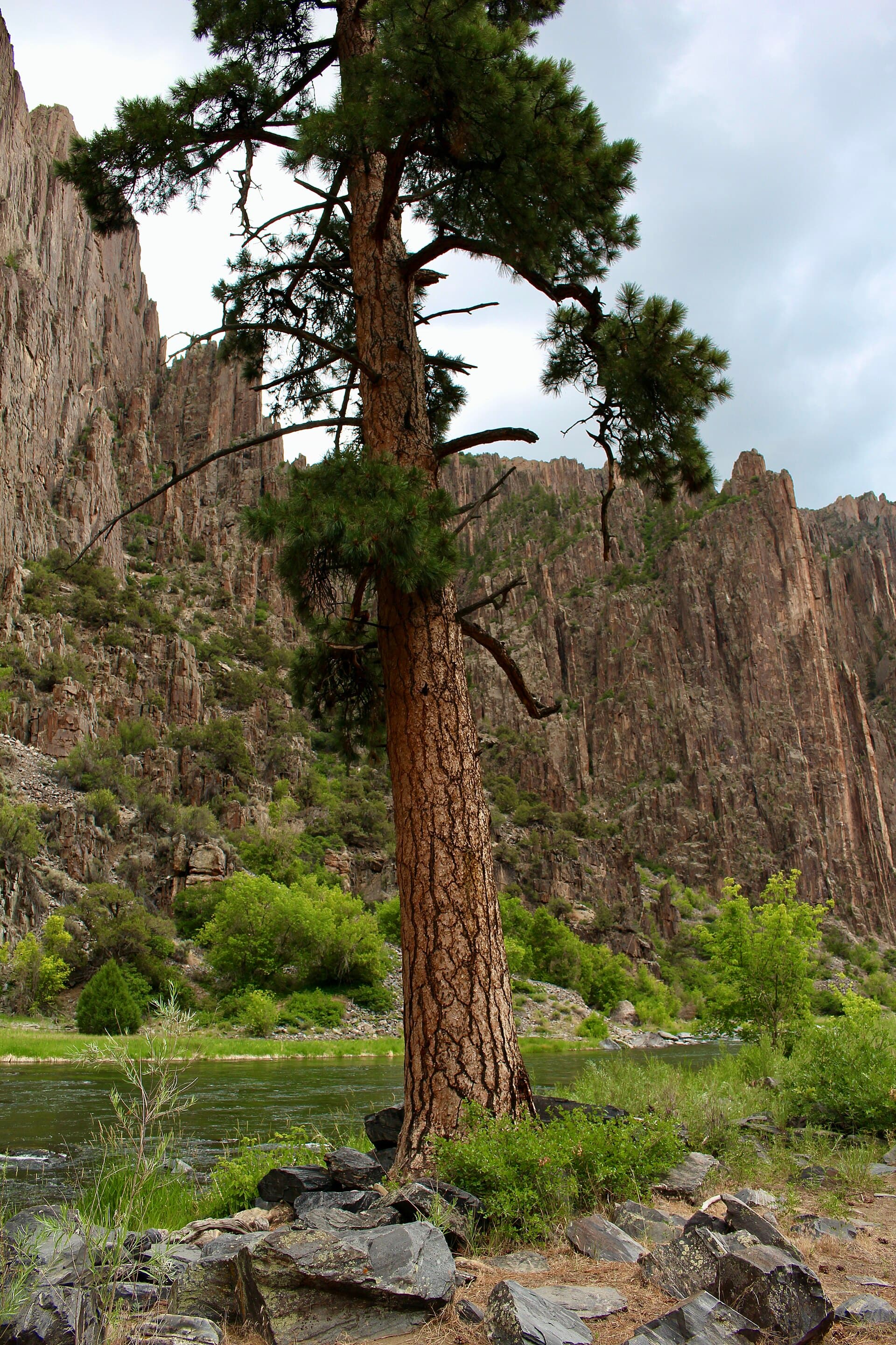
Red Rock Canyon hike highlights

  1. A maximum of 8 users and 4 permits per day for the entire canyon
  2. 3.5 miles one way with a gradual 1,300 foot drop to the river
  3. Numerous stream crossings that can make finding the route a challenge
  4. Poison ivy that can be shoulder high along the lower third and the river bank
  5. Gold Medal water fishing, with a Colorado license required for anyone 16 and older

How hard the Red Rock Canyon hike is

  • Physical DemandFitness and endurance required3/5
  • Technical SkillClimbing, scrambling, or specialized skills2/5
  • Exposure RiskSteep dropoffs and fall potential2/5
  • NavigationRoute finding and trail clarity3/5
  • CommitmentDifficulty of bailing out mid-route3/5

Best for: Anglers and hikers who want to reach the Gunnison River without downclimbing a scree gully, and who do not mind wet feet.

Recommended experience: Basic route finding. There is no marked trail and the creek crossings hide the line.

Not recommended for: Anyone highly sensitive to poison ivy, or anyone planning more than two nights.

Trailhead information

Red Rock Canyon parking area

Primary

The only access. Small lot at the end of 5.6 miles of dirt on Bostwick Park Road.

  • No restrooms
  • No water
  • No Service

Before you rely on this water

No water at the trailhead. Bring one liter per person for each hour of hiking or treat Gunnison River water upstream of the canyon route. Do not use the water flowing along the trail, which may contain harmful bacteria.

Parking

One vehicle per group is included with the permit. Display the permit number on the dashboard as your parking pass.

Getting There

From US Highway 50 turn north on State Route 347, drive about 1.8 miles to a flat area with ranches, turn left onto Bostwick Park Road, and follow the dirt road about 5.6 miles to the parking area.

Nearest Services

Montrose, about 30 minutes away.

When to hike Red Rock Canyon

Best time to visit

Late August through October. Snowmelt can make fishing and even approaching the river impossible earlier in the reservation season, and flooding is possible from mid-May to mid-July.

Peak
May 1 through October 31
Shoulder
Late April and early November
  • Spring

    High water. Depending on snowpack and melt-off, fishing and even approaching the river may not be possible.

    Crowd level · low

    • Advantage: First reservation window opens April 1
    • Advantage: Cool walking
    • Challenge: Flooding possible from mid-May
    • Challenge: River may be unapproachable
    • Challenge: Poison ivy leafing out
  • Summer

    Warm and green, with the poison ivy at full height and the river dropping.

    Crowd level · moderate

    • Advantage: Long days
    • Advantage: Warm river-level nights
    • Challenge: Peak poison ivy
    • Challenge: Two-night season cap applies May 1 to July 31
    • Challenge: Heat in the canyon
  • Fall

    The best window. Low clear water, cool air and no bugs.

    Crowd level · moderate

    • Advantage: Best fishing conditions
    • Advantage: Comfortable temperatures
    • Advantage: Poison ivy dying back
    • Challenge: Season ends October 31
    • Challenge: Cold nights at river level
  • Winter

    Off season. Permits are first-come first-served outside the South Rim Visitor Center.

    Crowd level · low

    • Advantage: Walk-up permits
    • Advantage: Complete solitude
    • Challenge: Snow and ice on the route
    • Challenge: Very cold at river level
    • Challenge: Short days

Weather Forecast

Trailhead (5,000 ft)

⚠️

Backcountry Tips

  • Tomorrow: 60% chance of precipitation. Pack rain gear.

Today

☁️

63°

51°

Wed

🌧️

60°

51°

60%

Thu

☁️

70°

47°

Fri

☁️

74°

52°

Sat

☁️

76°

54°

Sun

⛅

76°

54°

Mon

🌧️

73°

56°

View full NWS forecast →Mountain weather changes rapidly. This forecast is a guide—always be prepared for worse conditions.

Red Rock Canyon photography guide

Golden Hour

Late light on the canyon walls above the river, when the shadowed inner canyon still has color on top.

Best Light

Overcast days are best down here. Hard sun creates contrast the canyon cannot hold.

Beat the Crowds

With four permits a day this route is never crowded. Weekday nights in September are effectively private.

Classic Shots

  1. The Gunnison River between the canyon walls from a riverside camp
  2. Creek crossings framed by red rock in the mid-canyon
  3. A fly line on Gold Medal water
  4. Ponderosa on the river bank with the canyon rising behind

Red Rock Canyon rules, gear and safety

Gear checklist

Required
  • One liter of water per person for each hour of hiking, plus treatment for river water
  • Shoes you can soak, because the route crosses the creek repeatedly
  • Long pants for the poison ivy sections
  • WAG bag or another human waste containment system
  • Colorado fishing license if anyone 16 or older in your group plans to fish

Recommended gear

  • Poison ivy wash for after the trip
  • Bear-resistant food storage, since bears are in the area
  • Trekking poles for the creek crossings
  • A printed map, because the route is unmarked and unmaintained

Rules & regulations

  1. 01Maximum 8 users per day, maximum 4 permits or groups per day, maximum group size 4
  2. 02Maximum 2 nights per permit, and an individual permit holder may not exceed two nights during the entire peak season from May 1 to July 31
  3. 03Use established camping sites. Camping is prohibited in the parking area and along the trail
  4. 04Permits must be printed or downloaded within 7 days of the trip start date, and once printed no modifications are allowed
  5. 05One vehicle per group, with the permit number displayed on the dashboard
  6. 06Open fires, pets, livestock, hunting, wood cutting, drones and bicycles are prohibited
  7. 07Pack out everything including toilet paper. WAG bags are available at the trailhead
  8. 08Vacate campsites by 11 am on your exit day so the next group can find a site

Hazards & considerations

  • Poison ivy prolific along the lower section and the river, shoulder high in some spots
  • An unmarked and unmaintained route with numerous crossings where people lose the line
  • A river that is extremely cold, swift and dangerous. Do not attempt to wade or swim
  • Flooding possible from mid-May to mid-July, so check the USGS gauge below the Gunnison Tunnel before you go
  • No cell service anywhere in the Red Rock Canyon area
  • Water flowing along the trail that may contain harmful bacteria and should not be used

Safety & planning

Emergency Info

Emergency contacts, ranger station locations, and satellite communicator tips for Red Rock Canyon.

Food Storage

Bear canister requirements, approved container lists, and rental locations for this permit.

Gear Checklist: Required and recommended gear for Red Rock Canyon · Shuttle Services: Trailhead transportation options · Guide Services: Experienced wilderness guides

Some links may be affiliate links. Purchases support PermitSnag at no extra cost to you.

Red Rock Canyon FAQ

How do I get a Red Rock Canyon wilderness permit?

Reserve on Recreation.gov permit 4675335. Reservations open at 8:00 am Mountain Time in two windows: April 1 for trips from May 1 to July 31, and July 1 for August 1 to October 31. From November through April permits are first-come first-served outside the South Rim Visitor Center.

How many Red Rock Canyon permits are issued per day?

Recreation.gov states the maximum number of users per day is 8 and the maximum number of permits or groups per day is 4. Group size is capped at 4 and the maximum stay is 2 nights.

How long is the Red Rock Canyon route?

3.5 miles one way, gradually dropping 1,300 vertical feet to the Gunnison River. The first mile follows a two-track dirt road from the parking lot before the route proper begins.

Do I need a fishing license with a Red Rock Canyon permit?

Yes if you plan to fish. Park regulations and Gold Medal Waters fishing regulations apply, and a valid Colorado state fishing license is required for anyone 16 years old and up.

How much does a Red Rock Canyon wilderness permit cost?

A $10 permit reservation fee. The park's $30 vehicle entrance fee applies to all users of Red Rock Canyon and is valid for 7 days.

Red Rock Canyon trail conditions and trip reports

Trail Conditions

No active conditions reported

Sign in to report trail conditions.

Questions

No questions yet

Be the first to ask about Red Rock Canyon.

Trip Reports

Write Report

No trip reports yet

Be the first to share your experience at Red Rock Canyon.

Write the First Report

Alternatives to a Red Rock Canyon permit

  • Similar ExperiencePermit required

    Black Canyon South Rim routes

    The steep way to the same river, on the Gunnison and Warner routes with larger daily caps.

    Tradeoffs

    Much harder terrain and a bigger descent, but three nights instead of two and more permits available.

  • Same AreaPermit required

    Great Sand Dunes backcountry

    Colorado backcountry two and a half hours east with 20 permits a day instead of four.

    Tradeoffs

    No river and no fishing, but far easier to get.

  • Similar ExperiencePermit required

    Rocky Mountain wilderness camping

    Colorado alpine designated sites with a much bigger inventory.

    Tradeoffs

    Higher and colder, and busier all summer.

Where to stay near Red Rock Canyon

Plan the full trip, not just the permit

Build your full itinerary start to finish

Add your dates and get a day-by-day plan: what needs a permit, what gear to bring, and one link to share with your whole group to coordinate every step.

Plan a trip here

No permit needed to start

One tick helps us more than you’d think

Google lets you pick the sites it highlights for you. Add PermitSnag and our permit pages get marked as one of yours in AI Overviews and AI Mode.

Add PermitSnag in Google

Takes less than a minute.