Skip to content
Black Canyon South Rim Wilderness Permit permit area in Black Canyon of the Gunnison National Park - backcountry hiking destination
Each entry point carries its own quota

Black Canyon South Rim Wilderness Permit

Black Canyon of the Gunnison National Park · Colorado

One permit, one route, one entry date. Pick Gunnison or Warner, drop up to 2,722 feet of loose scree to the river, and camp at the bottom for up to three nights.

Get an alert when a spot opens in your Black Canyon South Rim zone.

Pick the zone you need

Black Canyon South Rim sells by zone. Pick the one you need and we'll scan just that zone for openings, so you don't hear about areas you can't use.

Narrow it down (optional)
Party

This permit allows up to 4 people per group.

70% of the openings our scanner caught on Black Canyon South Rim were gone within 10 minutes.

Black Canyon South Rim reservation dates

Season
May 1 to October 31
route distance, out and back
2.75mi
elevation gain
2,722ft
max group size
4people

Black Canyon South Rim elevation profile

Gunnison Route chain section to Warner Route river camp, one way

2,722 ft of descent · 18.7% average grade

Landmark

South Rim Visitor Center

Start of the Gunnison Route via the Oak Flat Trail, and where winter walk-up permits are issued.

Elevation
8,150 ft

Black Canyon South Rim landmarks

How to get a Black Canyon South Rim permit

As of September 2026, Black Canyon South Rim in Black Canyon of the Gunnison National Park, Colorado requires a permit issued via reservation. Black Canyon South Rim is a high-demand permit, rating 7/10 on PermitSnag's demand index. Cancelled Black Canyon South Rim permits are re-released on the booking system, and PermitSnag alerts you the moment one opens. The permit season for Black Canyon South Rim runs May 1 through October 31. The Black Canyon South Rim route covers 2.75 miles with 2,722 feet of elevation gain, rated expert.

Type
Backpacking
Location
Western Colorado, CO
  1. Step 1: Create a Recreation.gov account

    Sign up at Recreation.gov if you don't have an account. Have your payment info ready.

  2. Step 2: Know the release schedule

    Permits release on a rolling basis. Check the release time for your dates.

  3. Step 3: Be ready when permits drop

    Log in a few minutes early. Have your dates, group size, and payment ready to go.

  4. Step 4: Monitor for cancellations

    If your dates are sold out, people cancel all the time. Set up PermitSnag alerts to catch openings instantly.

Black Canyon South Rim pro tips

  1. Do not print or download the permit until you are sure. Printing issues it, and after that no changes, cancellations or refunds are possible.
  2. The Tomichi Route is closed to all use until further notice after the 2025 South Rim Fire. Gunnison and Warner remain open.
  3. Turn around and look behind you on the way down. Rangers say memorizing trees and boulders is the difference between a clean exit and getting off route.
  4. Winter permits are walk-up at the South Rim Visitor Center under the same daily quotas, which is the easiest way into this canyon.

More on Black Canyon South Rim: Live availability activityWhen Black Canyon South Rim permits open upDo I need a Black Canyon South Rim Wilderness permit?

How much a Black Canyon South Rim permit costs

Black Canyon South Rim permit fee: $6 reservation fee + $4 per person.

The Black Canyon South Rim hike

Distance
2.75 miles
Elevation Gain
2,722 ft
Route Type
Out & Back
Duration
1-3 nights
Difficulty
Expert
Elevation Range
5,590 - 8,303 ft

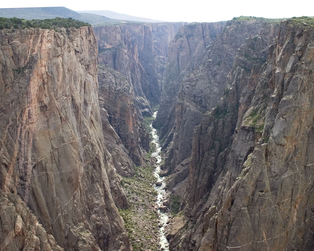
Descend a mile and a half of loose gully to a river almost nobody stands beside, in a canyon where the walls go up 2,000 feet on both sides of your tent.

About this permit

Black Canyon issues wilderness permits for South Rim routes only. The North Rim is not available online. These are not trails: the Park Service describes primitive, rugged, very strenuous routes that follow very steep gullies and rock chutes of loose dirt and rock, unmarked from top to bottom.

Each route has its own daily cap. Recreation.gov publishes Gunnison at 15, Tomichi at 9 and Warner at 23. Maximum group size is 4 and the maximum stay is 3 nights. Peak season runs May 1 through October 31 with reservations only, opening in two windows: April 1 for trips from May 1 to July 31, and July 1 for the rest of the season, both at 8:00 am Mountain Time. From November 1 through April 30 permits are first-come first-served outside the South Rim Visitor Center under the same daily quotas.

The route

The Gunnison Route starts at the South Rim Visitor Center and follows the Oak Flat Trail for a third of a mile before the switchbacks stop pretending to be a trail. It is 1.5 miles and a 1,800 foot vertical drop, with a chain to hold on to in the steepest section, and it is the most used way in.

The Warner Route is the long one. It leaves the Warner Point Nature Trail past marker 13 and covers 2.75 miles with a 2,722 foot vertical drop, which is the biggest descent on the South Rim and the reason it holds the largest daily quota at 23.

The Tomichi Route is 1 mile and 1,960 feet from a start about 100 yards south of the Tomichi Point overlook. It is closed to all use until further notice because of the 2025 South Rim Fire. Camping at the base of your route is allowed for up to three nights.

Why it matters

There are no maintained or marked trails into the inner canyon of the Black Canyon. What the Park Service issues here is permission to scramble down a gully to the Gunnison River, and the daily caps are tiny: 15 people on the Gunnison Route, 23 on Warner. It is one of the smallest wilderness quotas in the National Park System.

The feeling

Going down is intuitive. Coming back up is where people get lost, which is why rangers tell you to keep turning around and memorizing trees and boulders on the way down. At the bottom the river is loud, cold and green, the walls block most of the sky, and the sun shows up for a couple of hours and then leaves.
Black Canyon South Rim hike highlights

  1. Daily caps of 15 on Gunnison, 23 on Warner and 9 on Tomichi
  2. Routes of 1 to 2.75 miles with vertical drops from 1,800 to 2,722 feet
  3. No maintained or marked trail anywhere in the inner canyon
  4. Round trips that typically take 4 to 8 hours, before you add a camp
  5. The Tomichi Route closed to all use until further notice after the 2025 South Rim Fire

How hard the Black Canyon South Rim hike is

  • Physical DemandFitness and endurance required4/5
  • Technical SkillClimbing, scrambling, or specialized skills3/5
  • Exposure RiskSteep dropoffs and fall potential4/5
  • NavigationRoute finding and trail clarity4/5
  • CommitmentDifficulty of bailing out mid-route4/5

Best for: Scramblers comfortable on steep loose ground who can find their own way back up an unmarked gully.

Recommended experience: Prior off-trail scrambling with a loaded pack. The park asks you to review route info and talk to a ranger if you have not done these before.

Not recommended for: Anyone uneasy on loose rock, anyone who has not scrambled with a pack, and anyone expecting a trail.

Trailhead information

South Rim Visitor Center (Gunnison Route)

Primary

8,000 ft elevation

Start of the Gunnison Route. 1.5 miles and 1,800 vertical feet to the river.

  • Restrooms
  • Water on site
  • Weak Signal

Before you rely on this water

Water at the visitor center in season. The only water below the rim is the Gunnison River itself, and everything from it needs filtering.

Parking

Visitor center lot. Display your permit number on the dashboard.

Getting There

Colorado Highway 347 north from US Highway 50, about 6 miles to the South Rim entrance.

Nearest Services

Montrose, about 15 miles southwest, has everything.

Trailhead information

High Point (Warner Route)

Alternate

Start of the Warner Route via the Warner Point Nature Trail. 2.75 miles and 2,722 vertical feet.

  • Restrooms
  • No water
  • No Service

Before you rely on this water

No water at High Point. Carry 4 liters per person per day, which is what the park recommends for these routes.

Parking

Lot at the end of South Rim Road at High Point.

Getting There

Drive to the end of South Rim Road. Closed in winter beyond the visitor center.

Nearest Services

Montrose.

When to hike Black Canyon South Rim

Best time to visit

May through October, which is the reservation season. Most South Rim routes are snow-covered from November to April, when permits switch to first-come first-served at the visitor center.

Peak
May 1 through October 31
Shoulder
Late April and early November
  • Spring

    Snow clearing off the routes through May, with high water in the river.

    Crowd level · moderate

    • Advantage: Cool descending temperatures
    • Advantage: First reservation window opens April 1
    • Challenge: Lingering snow and ice in the gullies
    • Challenge: High, fast river
  • Summer

    Hot. The inner canyon runs 5 to 10F warmer than the rim and heat exhaustion is the most common injury on these routes.

    Crowd level · high

    • Advantage: Longest daylight for a long day down and up
    • Advantage: All routes at their driest
    • Challenge: Heat exhaustion
    • Challenge: Afternoon thunderstorms
    • Challenge: The smallest quotas of any park on this list
  • Fall

    The best conditions of the year. Cool, dry and quiet through October.

    Crowd level · moderate

    • Advantage: Comfortable temperatures on the climb out
    • Advantage: Stable weather
    • Advantage: Second reservation window opened July 1
    • Challenge: Shorter days for a 4 to 8 hour round trip
    • Challenge: Season ends October 31
  • Winter

    Most South Rim routes are snow-covered from November to April. Permits are walk-up only.

    Crowd level · low

    • Advantage: First-come first-served permits at the visitor center
    • Advantage: Same daily quotas with almost no competition
    • Challenge: Snow and ice on already-loose gullies
    • Challenge: Traction devices recommended
    • Challenge: South Rim Road closed beyond the visitor center

Weather Forecast

Trailhead (5,000 ft)

⚠️

Backcountry Tips

  • Tomorrow: 60% chance of precipitation. Pack rain gear.

Today

☁️

63°

51°

Wed

🌧️

60°

51°

60%

Thu

☁️

70°

47°

Fri

☁️

74°

52°

Sat

☁️

76°

54°

Sun

⛅

76°

54°

Mon

🌧️

73°

56°

View full NWS forecast →Mountain weather changes rapidly. This forecast is a guide—always be prepared for worse conditions.

Black Canyon South Rim photography guide

Golden Hour

Sunrise light reaches the top third of the opposite wall first and then walks down it. From the bottom it is the only warm light you get.

Best Light

The inner canyon is in shadow most of the day, which is the picture. Shoot the walls, not the sky.

Beat the Crowds

Warner is nearly twice as long as Gunnison and holds the largest quota, which means it is the least likely to feel occupied.

Classic Shots

  1. The Gunnison River from river level with both walls closing overhead
  2. Painted Wall from Chasm View on the rim before you drop in
  3. The chain section of the Gunnison Route
  4. A tent on the riverside boulders with 2,000 feet of rock above it

Black Canyon South Rim rules, gear and safety

Gear checklist

Required
  • 4 liters of water per person per day, or a filter and the plan to reach the river
  • Gloves. The gullies are loose rock and you will use your hands
  • Boots with real tread for descending scree with a pack
  • WAG bag or another solid waste containment system
  • Headlamp, since these routes take longer than people expect

Recommended gear

  • Bear-proof canister, which the park highly recommends because bears are active much of the year
  • Helmet for rockfall in the gullies, especially with a party above you
  • Traction devices for the November through April season, when the routes are usually snow-covered
  • Trekking poles for the ascent

Rules & regulations

  1. 01Reservations cover South Rim routes only. North Rim permits are not available online
  2. 02Maximum group size is 4 and the maximum stay is 3 nights
  3. 03You must watch the wilderness route orientation video and the route specific video before your trip
  4. 04Printing or downloading your permit issues it. After that no modifications, cancellations or refunds are possible
  5. 05Open fires, pets, livestock, hunting, wood cutting, drones and bicycles are prohibited
  6. 06Disposal of solid human waste is prohibited within 100 feet of the Gunnison River high water mark, so carry a WAG bag
  7. 07Commercial use including guided fishing, hiking or camping is prohibited in the inner canyon zone
  8. 08Display the permit number on your vehicle dashboard

Hazards & considerations

  • Loose dirt and rock on steep gullies, where a slip has real consequences
  • Getting off route on the way up, which the park calls a common issue
  • Inner canyon temperatures 5 to 10F warmer than the rim, and heat exhaustion as the most common injury
  • Rescue that takes many hours to over a day to mobilize, so you must be prepared for self-rescue and unplanned overnights
  • A river that is swift, cold and deep, and not recommended for swimming or wading
  • Poison ivy and snow cover from November to April on most South Rim routes

Safety & planning

Emergency Info

Emergency contacts, ranger station locations, and satellite communicator tips for Black Canyon South Rim.

Food Storage

Bear canister requirements, approved container lists, and rental locations for this permit.

Gear Checklist: Required and recommended gear for Black Canyon South Rim · Shuttle Services: Trailhead transportation options · Guide Services: Experienced wilderness guides

Some links may be affiliate links. Purchases support PermitSnag at no extra cost to you.

Black Canyon South Rim FAQ

How do I get a Black Canyon wilderness permit?

Reserve on Recreation.gov permit 4675344 during the May 1 to October 31 season. Reservations open in two windows at 8:00 am Mountain Time: April 1 for trips from May 1 to July 31, and July 1 for the rest of the season. From November 1 through April 30 permits are first-come first-served outside the South Rim Visitor Center.

How many Black Canyon wilderness permits are issued per day?

Recreation.gov publishes a maximum number of hikers per day per route: Gunnison 15, Tomichi 9 and Warner 23. Maximum group size is 4 and the maximum stay is 3 nights.

Is the Tomichi Route open on a Black Canyon wilderness permit?

No. Recreation.gov states that due to the effects of the 2025 South Rim Fire, the Tomichi route is closed to all use until further notice. The Gunnison and Warner routes remain open under the same conditions and reservation system.

How hard are the Black Canyon wilderness routes?

The Park Service describes them as primitive, rugged and very strenuous, following steep gullies and rock chutes of loose dirt and rock with no maintained or marked trail. Round trips typically take 4 to 8 hours. Warner drops 2,722 feet in 2.75 miles and Gunnison drops 1,800 feet in 1.5 miles.

How much does a Black Canyon wilderness permit cost?

A $6 reservation fee plus $4 per person. The park's $30 vehicle entrance fee is required separately and is valid for 7 days.

Black Canyon South Rim trail conditions and trip reports

Trail Conditions

No active conditions reported

Sign in to report trail conditions.

Questions

No questions yet

Be the first to ask about Black Canyon South Rim.

Trip Reports

Write Report

No trip reports yet

Be the first to share your experience at Black Canyon South Rim.

Write the First Report

Alternatives to a Black Canyon South Rim permit

  • Easier AlternativePermit required

    Black Canyon Red Rock Canyon

    The same river on the same permit system by a gentler 3.5 mile route that drops 1,300 feet instead of 2,722.

    Tradeoffs

    Far easier walking, but only 8 people per day and a maximum of two nights.

  • Same AreaPermit required

    Great Sand Dunes backcountry

    Colorado backcountry two hours east with at-large camping and a much larger daily cap.

    Tradeoffs

    No scrambling and no route finding, but no river either.

  • Similar ExperiencePermit required

    Rocky Mountain wilderness camping

    Colorado alpine backcountry with real trails and far more sites.

    Tradeoffs

    Much easier terrain and much harder to get in summer.

Where to stay near Black Canyon South Rim

Plan the full trip, not just the permit

Build your full itinerary start to finish

Add your dates and get a day-by-day plan: what needs a permit, what gear to bring, and one link to share with your whole group to coordinate every step.

Plan a trip here

No permit needed to start

One tick helps us more than you’d think

Google lets you pick the sites it highlights for you. Add PermitSnag and our permit pages get marked as one of yours in AI Overviews and AI Mode.

Add PermitSnag in Google

Takes less than a minute.