Skip to content
The Subway Permit permit area in Zion National Park - backcountry hiking destination
Cancellations all season · lottery when it opens

The Subway Permit

Zion National Park · Utah

Technical canyoneering through a tube-shaped slot canyon, one of Zion's most spectacular and photogenic routes.

Get an alert when The Subway opens on your dates.

Get alerts for your The Subway dates

One The Subway reservation is one date. Tell us every date you'd take and we'll ping you the second one of them opens up.

Leave the second date blank if only one day works. A wider window catches more openings.

Party

When it opens

Every day
We alert you the moment a cancellation opens.You book it on Recreation.gov.
2 days
Lottery opens two days before your entry dateThe remaining 25% of the spotsYou apply on Recreation.gov.

After the draw, your alert keeps catching cancellations.

Source: recreation.gov

70% of the openings our scanner caught on The Subway were gone within 5 minutes.

The Subway dates: cancellations and the lottery

Application window
Opens Quarterly: February 1, May 1, August 1, November 1. Closes The 25th of the opening month
Results
Two days after the lottery closes
Season
Year-round
route distance, point to point
9.5mi
elevation gain
2,000ft
max group size
12people

The Subway elevation profile

Wildcat Canyon Trailhead to Left Fork Trailhead

3,873 ft of descent · 4% average grade

Landmark

Wildcat Canyon Trailhead

Top-down start point on Kolob Terrace Road. Elevation 6,600 ft.

Mile 0 of 9.5
0 Wildcat Canyon Trailhead9.5 Left Fork Trailhead
Mile
0
Elevation
6,973 ft

The Subway landmarks

How to get a The Subway permit

As of September 2026, The Subway in Zion National Park, Utah requires a permit issued via lottery. The Subway is a high-demand permit, rating 8/10 on PermitSnag's demand index. Cancelled The Subway permits are re-released on the booking system, and PermitSnag alerts you the moment one opens. The The Subway lottery opens Quarterly: February 1, May 1, August 1, November 1 and closes The 25th of the opening month, with results announced Two days after the lottery closes. The The Subway route covers 9.5 miles with 2,000 feet of elevation gain, rated strenuous.

Type
Canyoneering
Location
Colorado Plateau, UT
  1. Step 1: Check for cancellations

    Permits get cancelled daily. Peak cancellation times are 24-48 hours before the trip date.

  2. Step 2: Set up PermitSnag alerts

    Get notified when cancellations happen. Pro and $19 single-permit alerts are checked about every minute, 24/7; free accounts are checked hourly.

  3. Step 3: Create a Recreation.gov account

    Sign up at Recreation.gov if you don't have an account. Verify your email and add payment info ahead of time.

  4. Step 4: Apply during the lottery window

    Submit your application between Quarterly: February 1, May 1, August 1, November 1 and The 25th of the opening month. Apply for multiple dates to increase your odds.

  5. Step 5: Wait for lottery results

    Results are announced Two days after the lottery closes. Check your email and your Recreation.gov account.

The Subway pro tips

  1. One permit covers both the top-down canyoneering route and the bottom-up hike, so pick your direction after you win
  2. Set a cancellation alert: unclaimed reservations hit the calendar at 10am Mountain on the 15th of the month after the quarterly lottery, and the Canyoneering Daily Lottery runs two days out
  3. Zion will not let you guide or be guided here, so bring your own rope skills
  4. The permit is a reservation, not a permit: you still pick up the paper at the Zion Canyon Visitor Center wilderness desk the day before or the day of

More on The Subway: Live availability activityWhen The Subway permits open upThe Subway lottery datesDo I need a The Subway permit?Estimate your lottery oddsBoost your odds with a pool

How much a The Subway permit costs

The Subway permit fee: $6 application + $10/person.

The Subway hike

Distance
9.5 miles
Elevation Gain
2,000 ft
Route Type
Point to Point
Duration
6-10 hours
Difficulty
Strenuous
Elevation Range
5,000 - 6,600 ft

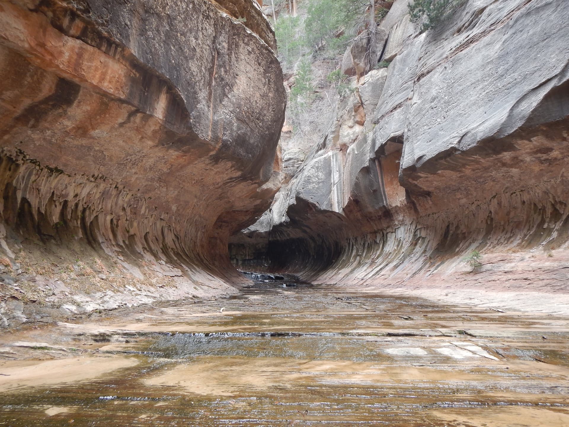
Descend through a natural subway tunnel carved in stone, where the canyon walls curve overhead like a sculpture gallery.

About this permit

The Subway is a famous slot canyon in the Kolob Terrace section of Zion National Park, named for its tubular shape where the walls curve inward at both floor and ceiling. There are two ways to experience it: a technical top-down canyoneering route (9.5 miles) requiring rappelling skills, or a non-technical bottom-up hike (8 miles round-trip) that visits the formation without requiring technical skills.

Both routes require a Wilderness Permit. The quarterly lottery hands out the first round, and unclaimed and cancelled reservations go back on the Recreation.gov calendar, which is what a cancellation alert checks. Commercial guiding is prohibited: all groups must be self-reliant.

The route

From Wildcat Canyon Trailhead, the top-down route descends Russell Gulch through slickrock terrain before dropping into the Left Fork of North Creek. The first rappels are short (30 feet at most) but commit you to the canyon.

The route follows the narrowing drainage, wading through pools that grow progressively deeper. Keyhole Falls requires either a rappel or a jump into deep water. Then the canyon walls begin to curve overhead, and you enter the Subway proper, the famous tubular section where the rock forms an almost complete tunnel.

The emerald pools here are jaw-dropping, and the North Pole, a massive log wedged vertically in the slot, marks the heart of the formation. Below, the Cascades offer one last obstacle before the canyon opens and you hike out to the Left Fork Trailhead.

Why it matters

The Subway is one of Zion's most iconic features, a tubular slot canyon where the walls curve inward at both the floor and ceiling, creating a tunnel-like space. It has appeared in countless photographs and represents the pinnacle of sandstone erosion art. The top-down route is considered one of the finest introductory canyoneering routes in the Southwest.

The feeling

The first rappel commits you to the canyon. As you descend, the walls close in and the light changes: filtered, ethereal, green with reflected water. Then the canyon opens into the Subway itself: a tube of rock where walls curve over your head and the emerald pools at your feet reflect a cathedral of stone. You're standing in a space that seems designed by an artist, not carved by water.
The Subway hike highlights

  1. Top-down: 9.5-mile point-to-point technical route with multiple rappels and cold-water swims
  2. Bottom-up: 8-mile round-trip strenuous hike with river wading and boulder scrambling
  3. Both routes involve extensive time in water: wetsuits recommended except in hot weather
  4. The iconic Subway formation with curving walls and emerald pools
  5. Remote canyon with no escape routes once committed

How hard the Subway hike is

  • Physical DemandFitness and endurance required4/5
  • Technical SkillClimbing, scrambling, or specialized skills4/5
  • Exposure RiskSteep dropoffs and fall potential3/5
  • NavigationRoute finding and trail clarity3/5
  • CommitmentDifficulty of bailing out mid-route4/5

Best for: Top-down: Experienced canyoneers with rappelling skills. Bottom-up: Strong hikers comfortable with river travel and scrambling.

Recommended experience: Top-down requires canyoneering experience and rope skills. Bottom-up requires hiking experience and comfort with river wading.

Not recommended for: Top-down route is not for beginners. Both routes unsuitable for those uncomfortable in water.

Trailhead information

Wildcat Canyon Trailhead (Top-Down Start)

Primary

6,973 ft elevation

Starting point for the technical top-down canyoneering route.

  • No restrooms
  • No water
  • No Service

Parking

Small dirt pullout on Kolob Terrace Road. Limited spaces.

Getting There

From Virgin, drive north on Kolob Terrace Road approximately 15 miles. Road may be closed in winter.

Nearest Services

Virgin (15 miles) has a small store. Full services in Springdale (25 miles).

Trailhead information

Left Fork Trailhead (Bottom-Up Start / Top-Down Exit)

Alternate

5,000 ft elevation

Primary trailhead for the non-technical bottom-up route or exit point for top-down route.

  • Restrooms
  • No water
  • No Service

Parking

Larger parking area with vault toilet. Requires shuttle or two-car setup for top-down route.

Getting There

From Virgin, drive north on Kolob Terrace Road approximately 8 miles.

Nearest Services

Virgin (8 miles) or Springdale (20 miles).

When to hike The Subway

Best time to visit

Summer (June-September) offers the warmest water temperatures but also highest flash flood risk. Spring and fall are ideal with moderate temperatures. Winter is possible but requires full wetsuits.

Weather Forecast

Trailhead (5,000 ft)

Today

☁️

82°

54°

Thu

☀️

84°

58°

Fri

☀️

82°

65°

Sat

☁️

85°

67°

Sun

⛅

84°

66°

Mon

☀️

79°

65°

Tue

☁️

82°

66°

View full NWS forecast →Mountain weather changes rapidly. This forecast is a guide—always be prepared for worse conditions.

The Subway photography guide

Golden Hour

The Subway's tubular section is sheltered from direct sunlight. Midday offers the best light penetration into the slot.

Best Light

Late morning to early afternoon provides the best light in the Subway section itself. Emerald pools photograph best with soft, reflected light.

Beat the Crowds

Every trip through the Left Fork is on a daily permit quota, so the canyon is never crowded. Start early for the best light and fewest people.

Classic Shots

  1. The curving Subway walls with emerald pool reflections
  2. The North Pole log wedged in the slot
  3. Looking up at the tubular ceiling of the Subway
  4. The Cascades waterfall section
  5. Rappelling into the canyon (top-down route)

The Subway rules, gear and safety

Gear checklist

Required
  • Technical canyoneering gear for top-down route (60-foot rope, harness, rappel device, helmet)
  • Dry bags for electronics and spare clothes
  • Sturdy footwear with good traction (canyon shoes or approach shoes)
  • Water and food for full day
  • Headlamp for emergency

Recommended gear

  • Wetsuit or drysuit (water is cold year-round)
  • Neoprene socks or booties
  • Webbing and rapid links for anchor replacement (top-down)
  • Waterproof camera or housing
  • Spare dry clothes in dry bag

Rules & regulations

  1. 01Wilderness permit required year-round for all trips (top-down or bottom-up)
  2. 02Group size limited to 12 people
  3. 03Groups may not split into multiple trips to exceed the 12-person daily limit
  4. 04Commercial guiding prohibited: groups must be self-reliant
  5. 05Human waste must be packed out (WAG bags required)
  6. 06No pets permitted

Hazards & considerations

  • Flash floods: do not enter if rain is in the forecast anywhere in the watershed
  • Cold water: hypothermia risk exists year-round
  • Technical skills required for top-down route: inexperienced canyoneers have died here
  • No escape routes once in the technical section
  • Slippery rock and deep pools create fall hazards

Safety & planning

Emergency Info

Emergency contacts, ranger station locations, and satellite communicator tips for The Subway.

Food Storage

Bear canister requirements, approved container lists, and rental locations for this permit.

Gear Checklist: Required and recommended gear for The Subway · Shuttle Services: Trailhead transportation options · Guide Services: Experienced wilderness guides

Some links may be affiliate links. Purchases support PermitSnag at no extra cost to you.

The Subway FAQ

How do I get a Subway permit in Zion?

Three ways, all on Recreation.gov permit 4251917. Unclaimed and cancelled reservations go on the calendar at 10am Mountain Time on the 15th of the month after results, which is what a cancellation alert catches. The Seasonal Lottery opens February 1, May 1, August 1 and November 1 and closes on the 25th, each covering the next calendar quarter of hike dates. And the separate Canyoneering Daily Lottery runs two days before your hike date.

Do the top-down and bottom-up Subway routes need different permits?

No. Recreation.gov 4251917 says the park "does not distinguish between top-down and bottom-up hikers for purposes of the quota," and both variations are booked from the same page. You choose your direction when you plan, not when you apply.

How many people can be on one Subway permit?

Twelve. NPS puts the Left Fork of North Creek in the same group as Keyhole, Pine Creek, the Narrows and Orderville: "Maximum group size in Keyhole, Pine Creek, the Narrows, Orderville, and the Left Fork (Subway) is 12 people." Splitting a bigger party into two groups on the same day is not allowed.

What does a Subway permit cost?

A $6 application or reservation fee that is never refunded, plus $10 per person that is refundable if you cancel before 5pm on the day of the trip. Zion's entrance fee is separate.

Alternatives to a The Subway permit

  • Easier AlternativePermit required

    The Subway Bottom-Up (Non-Technical)

    An 8-mile round-trip route that visits the Subway formation without technical canyoneering. Same permit, no rappelling required.

    Tradeoffs

    Same spectacular destination without the technical skills. Still strenuous with river wading and boulder scrambling.

  • Similar ExperiencePermit required

    Orderville Canyon

    A beautiful slot canyon that enters The Narrows, requiring wading but no technical skills.

    Tradeoffs

    Easier permit access and no canyoneering experience required. Narrower and more intimate than The Subway.

Plan the full trip, not just the permit

Build your full itinerary start to finish

Add your dates and get a day-by-day plan: what needs a permit, what gear to bring, and one link to share with your whole group to coordinate every step.

Plan a trip here

No permit needed to start

Two ways to land it

Track cancellations or run a lottery pool

Core feature

Fast Lane tracking

We check The Subway for cancellations 24/7 and alert you when a spot opens so you can book before it's gone.

Set a free cancellation alert
Pro or $19 alert

Lottery pool

Apply with a crew. Each person multiplies your combined odds. We coordinate invites, deadlines, and outcomes.

See plans to start a pool

Most crews do both: get alerts for cancellations, and pool for the lottery.

Lottery concierge

Your next shot at The Subway

Missed the draw or skipped it? Set an alert and we tell you the moment a The Subway cancellation opens. We remind you about the lottery dates too.

Better odds with a crew

The Subway permits are drawn by lottery. Every friend who applies adds another entry, so a crew gets more shots at the same permit than any one of you alone.

One of you runs the pool (Pro or a $19 alert). Everyone else joins free.

Know the moment you win

Auto win-detection tells you the moment your The Subway application wins, so you never have to check Recreation.gov. It reads the result email you forward us, so it takes a one-time setup in your inbox (about two minutes, and we walk you through it). Auto win-detection is on Pro or a $19 permit alert.

Turn on auto win-detection
Apply now on Recreation.gov

Opens the official lottery. You submit your entry. We never automate or store your Recreation.gov login.

One tick helps us more than you’d think

Google lets you pick the sites it highlights for you. Add PermitSnag and our permit pages get marked as one of yours in AI Overviews and AI Mode.

Add PermitSnag in Google

Takes less than a minute.