Skip to content
The Narrows Top-Down Permit permit area in Zion National Park - backcountry hiking destination
One date at a time

The Narrows Top-Down Permit

Zion National Park · Utah

The complete 16-mile through-hike of Zion's most famous slot canyon, from Chamberlain's Ranch to Temple of Sinawava.

Get an alert when Narrows Top-Down opens on your dates.

Get alerts for your Narrows Top-Down dates

One Narrows Top-Down reservation is one date. Tell us every date you'd take and we'll ping you the second one of them opens up.

Leave the second date blank if only one day works. A wider window catches more openings.

Party

70% of the openings our scanner caught on Narrows Top-Down were gone within 10 minutes.

Narrows Top-Down reservation dates

route distance, point to point
16mi
elevation gain
334ft
max group size
12people

Narrows Top-Down elevation profile

Chamberlain's Ranch to Temple of Sinawava

1,763 ft of descent · 0.4% average grade

Landmark

Chamberlain's Ranch

Northern starting point at 5,800 ft on private ranch. 1.5-hour shuttle from Springdale.

Mile 0 of 16
0 Chamberlain's Ranch16 Temple of Sinawava
Mile
0
Elevation
5,840 ft

Narrows Top-Down landmarks

How to get a Narrows Top-Down permit

As of September 2026, Narrows Top-Down in Zion National Park, Utah requires a permit issued via reservation. Narrows Top-Down is a high-demand permit, rating 7/10 on PermitSnag's demand index. Cancelled Narrows Top-Down permits are re-released on the booking system, and PermitSnag alerts you the moment one opens. The Narrows Top-Down route covers 16 miles with 334 feet of elevation gain, rated strenuous.

Type
Day Use
Location
Colorado Plateau, UT
  1. Step 1: Create a Recreation.gov account

    Sign up at Recreation.gov if you don't have an account. Have your payment info ready.

  2. Step 2: Know the release schedule

    Permits release on a rolling basis. Check the release time for your dates.

  3. Step 3: Be ready when permits drop

    Log in a few minutes early. Have your dates, group size, and payment ready to go.

  4. Step 4: Monitor for cancellations

    If your dates are sold out, people cancel all the time. Set up PermitSnag alerts to catch openings instantly.

More on Narrows Top-Down: Live availability activityWhen Narrows Top-Down permits open upChance of an openingDo I need a The Narrows Top-Down permit?

How much a Narrows Top-Down permit costs

Narrows Top-Down permit fee: $15.

The Narrows Top-Down hike

Distance
16 miles
Elevation Gain
334 ft
Route Type
Point to Point
Duration
10-14 hours
Difficulty
Strenuous
Elevation Range
4,400 - 5,800 ft

Wade 16 miles down the Virgin River through walls that rise 2,000 feet overhead, the ultimate slot canyon experience.

About this permit

The Narrows Top-Down is a 16-mile through-hike down the North Fork of the Virgin River, Zion's most famous slot canyon. Unlike the bottom-up day hike, this route requires a wilderness permit and a shuttle to the remote Chamberlain's Ranch trailhead.

The hike can be completed as a strenuous 10-14 hour day or as a more leisurely 2-day backpacking trip with camping at one of 12 designated riverside camps. Most of the route involves wading directly in the river.

The route

From Chamberlain's Ranch, the first miles feel almost too easy: a gravel road through ponderosa pines and meadows. Then you drop into the riverbed and the transformation begins.

The canyon walls grow gradually at first, rising and narrowing imperceptibly. At Deep Creek confluence, the river doubles in volume and the real Narrows begins. The famous landmarks appear in sequence: Big Springs with its hanging gardens, Orderville Canyon entering from the left, and finally Wall Street, where the canyon narrows to 20 feet while the walls soar to 2,000.

The final mile along the Riverside Walk feels almost surreal: paved trail after 15 miles of river walking. You emerge at Temple of Sinawava changed, with wrinkled feet and a memory you'll carry forever.

Why it matters

The Narrows is the narrowest section of Zion Canyon, where the Virgin River has carved a slot so deep and tight that the walls tower 2,000 feet overhead while squeezing to just 20 feet wide. It is widely considered one of the top hikes in the United States and the defining experience of Zion National Park.

The feeling

There's no trail in The Narrows, only the river. For 16 miles, you wade downstream through water that varies from ankle-deep riffles to chest-deep pools. The walls rise around you like a cathedral, narrowing until you're in Wall Street, the famous section where 2,000-foot cliffs squeeze to 20 feet apart and you cannot see sky. The river is your highway, the canyon your temple.
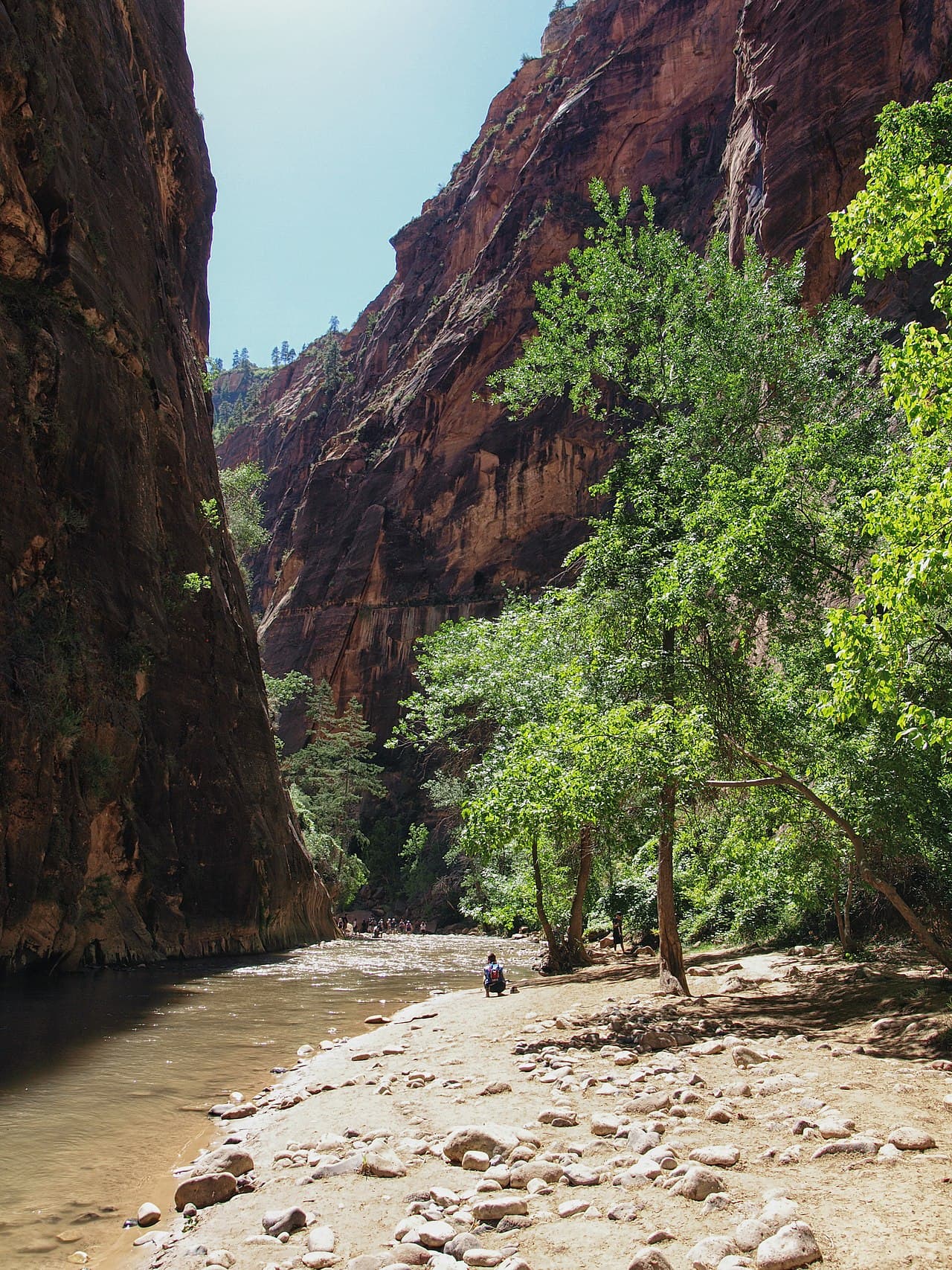
Narrows Top-Down hike highlights

  1. 16 miles of river hiking with constant wading (ankle to chest-deep)
  2. 10-14 hours for strong hikers; 2 days for a more relaxed pace
  3. No maintained trail: the river IS the trail
  4. The famous Wall Street section with 2,000-foot walls narrowing to 20 feet
  5. Cold water year-round (56-68°F depending on season)

How hard the Narrows Top-Down hike is

  • Physical DemandFitness and endurance required4/5
  • Technical SkillClimbing, scrambling, or specialized skills2/5
  • Exposure RiskSteep dropoffs and fall potential2/5
  • NavigationRoute finding and trail clarity1/5
  • CommitmentDifficulty of bailing out mid-route4/5

Best for: Strong hikers comfortable with extensive river travel and cold water immersion.

Recommended experience: River crossing experience helpful. Should have completed at least one full-day strenuous hike.

Not recommended for: Hikers under 4'8" (chest-deep crossings), those unable to swim, anyone uncomfortable in moving water.

Trailhead information

Chamberlain's Ranch

Primary

5,800 ft elevation

Northern starting point for top-down route. Private ranch: shuttle or 2-car setup required.

  • No restrooms
  • No water
  • No Service

Parking

No public parking. Must arrange private shuttle or two-car spot.

Getting There

1.5-hour drive from Springdale via Highway 9 East, then north on North Fork Road. Dirt road may be impassable when wet.

Nearest Services

None at trailhead. Springdale or Orderville have full services.

Trailhead information

Temple of Sinawava

Alternate

4,400 ft elevation

Southern endpoint at Shuttle Stop #9. All top-down hikers exit here.

  • Restrooms
  • Water on site
  • No Service

Before you rely on this water

A filling station at the shuttle stop only. The Virgin River is not a substitute - Zion posts cyanobacteria advisories for it, and filters do not remove cyanotoxins. Carry everything you need and check the park's current conditions page before you go.

Parking

No parking: shuttle access only. Take Zion Canyon Shuttle to Stop #9.

Getting There

Access via free Zion Canyon shuttle from Visitor Center.

Nearest Services

Zion Lodge (shuttle accessible). Full services in Springdale.

When to hike Narrows Top-Down

Best time to visit

June through September offers the warmest water temperatures (65-68°F) but higher flash flood risk. Spring and fall have colder water but more stable weather. The route requires favorable river conditions. Check flow rates before planning.

Weather Forecast

Trailhead (4,400 ft)

Today

☁️

74°

55°

57%

Wed

☁️

87°

56°

Thu

☀️

88°

61°

Fri

☀️

85°

67°

Sat

☁️

87°

68°

Sun

☀️

88°

70°

Mon

🌧️

82°

68°

View full NWS forecast →Mountain weather changes rapidly. This forecast is a guide—always be prepared for worse conditions.

Narrows Top-Down photography guide

Golden Hour

The Narrows is shaded most of the day due to the deep canyon. Wall Street photographs best when occasional light beams penetrate the slot (typically midday).

Best Light

Overcast days provide even, soft light throughout the canyon. Direct sun creates harsh contrast between lit walls and dark shadows.

Beat the Crowds

Top-down hikers have the canyon largely to themselves until Big Springs, where bottom-up crowds begin. Start early to reach Wall Street before the masses.

Classic Shots

  1. Wall Street section with towering walls and narrow river
  2. Light beams in the slot canyon (requires specific conditions)
  3. Big Springs hanging gardens
  4. Wading hikers dwarfed by massive canyon walls
  5. Orderville Canyon junction
  6. Reflection shots in calm pools

Narrows Top-Down rules, gear and safety

Gear checklist

Required
  • Sturdy, high-top canyon shoes or boots with good drainage
  • Walking stick or sturdy trekking pole (wooden stick recommended over metal)
  • Dry bags for electronics, camera, and spare clothes
  • Water and food for full day
  • Headlamp (in case of extended time in canyon)

Recommended gear

  • Neoprene socks to keep feet warm in cold water
  • Wetsuit or drytop in spring/fall/winter
  • Waterproof camera or underwater housing
  • Gaiters to prevent rocks entering boots
  • Spare dry clothes for shuttle ride back

Rules & regulations

  1. 01Wilderness permit required for all top-down hikers
  2. 02Day-hiking or overnight options available
  3. 03Group size limited to 12 people
  4. 04Trail closes when river flow exceeds 150 CFS (permits not issued above 120 CFS)
  5. 05Camping only at 12 designated sites (overnight permit required)
  6. 06No fires permitted
  7. 07Human waste must be packed out (WAG bags required for overnight)

Hazards & considerations

  • Flash floods: the canyon is a death trap during heavy rain; check weather forecast for entire Virgin River watershed
  • Hypothermia: water is cold year-round; extended immersion dangerous
  • Deep water: some pools are chest-deep; short hikers may need to swim
  • Slippery rocks: the riverbed is covered in 'bowling ball' rocks that roll underfoot
  • No escape routes in Wall Street: once in the narrowest section, you're committed

Safety & planning

Emergency Info

Emergency contacts, ranger station locations, and satellite communicator tips for Narrows Top-Down.

Food Storage

Bear canister requirements, approved container lists, and rental locations for this permit.

Gear Checklist: Required and recommended gear for Narrows Top-Down · Shuttle Services: Trailhead transportation options · Guide Services: Experienced wilderness guides

Some links may be affiliate links. Purchases support PermitSnag at no extra cost to you.

Narrows Top-Down FAQ

How do I get a Narrows Top-Down permit?

PermitSnag alerts you the moment a Narrows Top-Down cancellation opens, so you can book it before anyone else. Narrows Top-Down permits use a reservation system.

When is the best time to visit Narrows Top-Down?

Season dates are on the agency's page. Weekdays have better availability than weekends.

How competitive is the Narrows Top-Down permit?

This permit has a demand score of 7/10, making it highly competitive. We recommend having backup dates and using PermitSnag's cancellation alerts.

What if I can't get a Narrows Top-Down permit?

Cancellations happen daily. Set up alerts with PermitSnag to get notified the moment a spot opens up. Pro and $19 single-permit alerts are checked about every minute, 24/7; free accounts are checked hourly.

Alternatives to a Narrows Top-Down permit

  • Easier AlternativeNo permit needed

    The Narrows Bottom-Up (No Permit)

    Day hike from Temple of Sinawava as far as Big Springs (up to 10 miles round trip). No permit or shuttle required.

    Tradeoffs

    Crowds are much heavier on this section, but no logistics or permit hassle. Sees the same Wall Street section.

  • Similar ExperiencePermit required

    The Narrows Overnight

    Same top-down route with overnight camping at one of 12 designated sites, allowing a more relaxed 2-day pace.

    Tradeoffs

    Same experience spread over two days. Permits for camping are harder to obtain than day-use permits.

Where to stay near Narrows Top-Down

Plan the full trip, not just the permit

Build your full itinerary start to finish

Add your dates and get a day-by-day plan: what needs a permit, what gear to bring, and one link to share with your whole group to coordinate every step.

Plan a trip here

No permit needed to start

One tick helps us more than you’d think

Google lets you pick the sites it highlights for you. Add PermitSnag and our permit pages get marked as one of yours in AI Overviews and AI Mode.

Add PermitSnag in Google

Takes less than a minute.