Lottery10/10
Half Dome
Required permit to climb the famous cables on Half Dome. One of the most sought-...
View Half Dome Day Hike Permit permit details and availability
The legendary 211-mile trail from Yosemite Valley to Mount Whitney. Multiple Donohue Pass-eligible trailheads offer different entry strategies.
“Walk 211 miles along the spine of the Sierra Nevada, from Yosemite Valley to the summit of Mount Whitney—the highest peak in the contiguous United States.”
Lottery + trailhead alerts— one setup covers both
Two ways to land it
We watch JMT Yosemite for cancellations 24/7 and alert you when a spot opens so you can book before it's gone.
Set trailhead alertsApply with a crew. Each person multiplies your combined odds (solo ~8%). We coordinate invites, deadlines, and outcomes.
See plans to start a poolMost crews do both: pool for the lottery, watch for cancellations.
Better odds with a crew
JMT Yosemite is a lottery — solo odds run about 8%. Every friend who applies adds another entry. Five of you, each applying: about 34%.
One of you runs the pool (Pro or a $12 alert). Everyone else joins free.
Mid-July through September offers the most reliable conditions. Early July may have challenging creek crossings and snow on high passes. September brings cooler temps, fewer crowds, and lower creek levels but also shorter days and early season snowstorms.
Sign up at Recreation.gov if you don't have an account. Verify your email and add payment info ahead of time.
Submit your application between Rolling weekly lottery, 24 weeks before entry. Apply for multiple dates to increase your odds.
Permits get cancelled daily. Peak cancellation times are 24-48 hours before the trip date.
Get instant notifications when cancellations happen. We check availability every 2-3 minutes, 24/7.
Trail generally snow-free above 11,000 ft by mid-July. Creeks can be high early in season.
Fitness and endurance required
Climbing, scrambling, or specialized skills
Steep dropoffs and fall potential
Route finding and trail clarity
Difficulty of bailing out mid-route
Experienced backpackers ready for a multi-week wilderness expedition with significant elevation and remote conditions.
Should have completed at least one multi-day backpacking trip of 50+ miles and have experience hiking at elevation above 10,000 feet.
First-time backpackers or those without experience in high-altitude mountain travel.
The John Muir Trail is a 211-mile continuous footpath through the heart of California's Sierra Nevada range, connecting Yosemite Valley to the summit of Mount Whitney. It passes through Yosemite, Kings Canyon, and Sequoia National Parks, traverses the Ansel Adams and John Muir Wilderness areas, and crosses 11 passes over 10,000 feet—including six over 11,000 feet.
Most thru-hikers complete the trail in 14-21 days, though fastpackers and trail runners have set records under 4 days. The route requires significant planning for food resupply (typically at Tuolumne Meadows, Red's Meadow, Muir Trail Ranch, and/or MTR food drop).
Named for the Scottish-American naturalist who championed the Sierra Nevada's protection, the John Muir Trail is America's most coveted long-distance hike. It traverses three national parks, two national forests, and passes through some of the most pristine wilderness remaining in the Lower 48. For many hikers, completing the JMT is a lifelong dream and a pilgrimage to the heart of the American West.
The trail begins at Happy Isles, climbing past the thundering curtains of Vernal and Nevada Falls. The first section through Yosemite is heavily trafficked, but solitude comes quickly after Little Yosemite Valley.
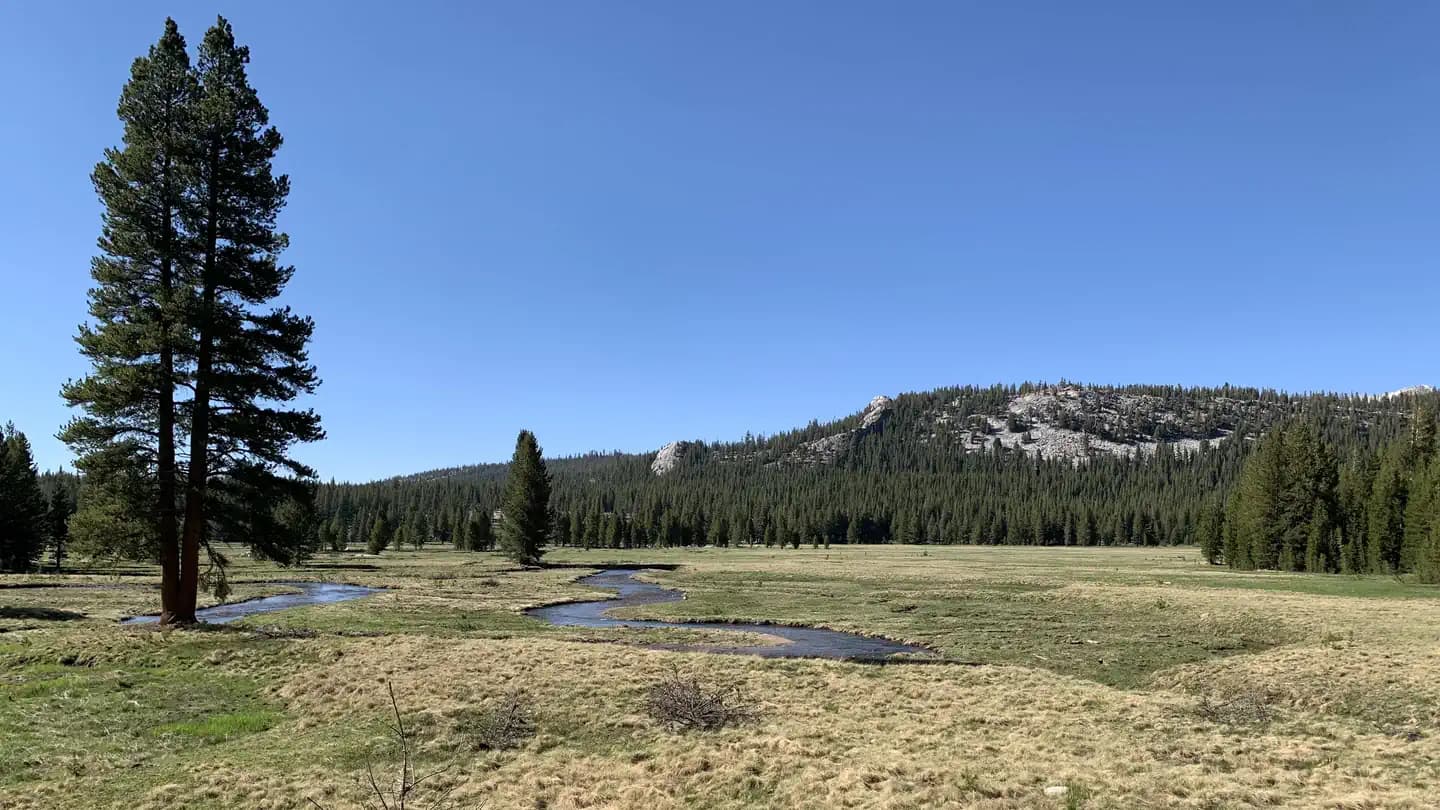
From Tuolumne Meadows, the trail enters the serene 8-mile stretch of Lyell Canyon, following the Lyell Fork through a broad glacial valley. Then comes the first major climb: Donohue Pass at 11,066 feet, marking the boundary between Yosemite and the Ansel Adams Wilderness.
Beyond lies a procession of high country: Island Pass, Thousand Island Lake beneath the spires of the Ritter Range, and the volcanic Devils Postpile. The trail winds through the John Muir Wilderness, crossing passes named for Sierra luminaries—Muir, Mather, Pinchot—each one higher than the last. The final push over Forester Pass (13,153 ft) leads to the climactic ascent of Mount Whitney, where 211 miles of trail culminate at 14,505 feet above sea level.
There's a rhythm to the JMT that takes hold after the first few days. Wake with the sun. Walk. Climb. Descend. Filter water. Walk more. By the end, you've internalized the Sierra—the way light falls on granite at golden hour, the scent of sun-warmed pine needles, the quiet thunder of a distant waterfall. Cresting Donohue Pass for the first time, with the whole of the Ansel Adams Wilderness spread below you, something shifts. You're no longer visiting the mountains. You're living in them.
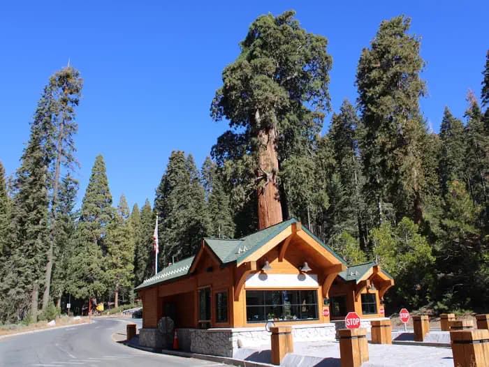
The traditional JMT starting point. Only 15 'Donohue Pass Eligible' permits issued daily from this trailhead.
No direct parking. Use Half Dome Village lot (fills early) or take shuttle to Stop #16.
Access via Yosemite Valley shuttle system.
Half Dome Village has general store, showers, and restaurants.
Alternative JMT start that skips Yosemite Valley crowds. 30 'Donohue Pass Eligible' permits issued daily.
Parking at Tuolumne Meadows Wilderness Center or Dog Lake parking area.
Requires Tioga Road to be open (typically June-November). 1.5 hours from Yosemite Valley.
Tuolumne Meadows store and grill (seasonal).
Scenic alternate start descending to Little Yosemite Valley. Donohue Pass eligible via LYV connection.
Glacier Point parking (seasonal road access, typically late May-October).
Glacier Point Road from Yosemite Valley; check seasonal opening.
Yosemite Valley services via shuttle or drive.
Required and recommended gear for JMT Yosemite
Trailhead transportation options
Browse all shuttlesExperienced wilderness guides
Browse all guidesSome links may be affiliate links. Purchases support PermitSnag at no extra cost to you.
~8%
estimated success rate
Get detailed lottery statistics and tips. Sign up to track this permit.
Apply with a crew to multiply your combined odds, and let auto win-detection tell you the moment you win — you never have to check Recreation.gov. Pool and auto win-detection are on Pro or a $12 permit alert.
Apply these for the best odds
12,453 permits and 8,294 campsites secured by PermitSnag users
JMT Yosemite permits use a lottery system. The lottery typically opens Rolling weekly lottery, 24 weeks before entry. PermitSnag sends lottery open, deadline, and results reminders; you can also enable cancellation alerts if spots open later.
The season typically runs July 1 to September 30. Weekdays generally have better availability than weekends.
This permit has a demand score of 10/10, making it extremely competitive. We recommend having backup dates and using PermitSnag's cancellation alerts.
Cancellations happen daily. Set up alerts with PermitSnag to get notified the moment a spot opens up. We check availability every 2-3 minutes, 24/7.
Thousand Island Lake at sunrise is the JMT's most iconic shot—the Ritter Range reflected in glassy water with the first light hitting Banner Peak.
For pass photography, early morning offers the best clarity and drama. The granite bowls of Evolution Basin glow in alpenglow both at dawn and dusk.
The first 25 miles from Yosemite Valley are the most crowded. Timing your start mid-week and camping beyond Tuolumne Meadows on day one provides more solitude.
Consider these alternatives if your preferred dates aren't available.
A 42-mile loop that traverses a spectacular section of the JMT without the full commitment. Covers some of the trail's most beautiful terrain including Rae Lakes.
Still requires permit but much easier to obtain. Shorter duration (3-5 days) but misses Yosemite and Whitney sections.
Enter the JMT from Onion Valley via Kearsarge Pass, hiking the southern 100 miles to Whitney. Inyo NF permits are easier to obtain than Yosemite permits.
Skips Yosemite section but covers the highest and most remote portions. Better permit odds.
A 72-mile east-west traverse from Crescent Meadow to Mount Whitney, intersecting the JMT at its climax.
Different route but shares the Whitney summit experience. Generally easier permits.
Nearby campgrounds to complete your JMT Yosemite trip
Permit Directory
Find permits for day hikes, overnight backpacking, thru-hikes, canyoneering, and river trips across federal and state lands.
Day-use, overnight, and wilderness permits at America's crown jewels
Sierra Nevada, Lost Coast, and backcountry access
Red rock canyons, slot canyon permits, and desert wilderness
USFS wilderness areas with quota systems
Multi-day point-to-point traverses and epic long-distance trails
Multi-day rafting and river access permits
Backcountry camping and trail permits
High-altitude summit permits and technical climbing routes